Download
1 / 31
310 likes | 451 Vues
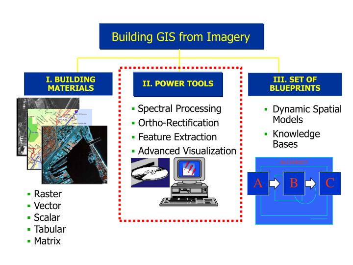
Building GIS from Imagery. I. BUILDING MATERIALS. II. POWER TOOLS. III. SET OF BLUEPRINTS. Dynamic Spatial Models Knowledge Bases. BLUEPRINT. A. B. C. IMAGERY. Raster Vector Scalar Tabular Matrix. Spectral Processing Ortho-Rectification Feature Extraction

E N D
Building GIS from Imagery I. BUILDING MATERIALS II. POWER TOOLS III. SET OF BLUEPRINTS • Dynamic Spatial Models • Knowledge Bases BLUEPRINT A B C IMAGERY • Raster • Vector • Scalar • Tabular • Matrix • Spectral Processing • Ortho-Rectification • Feature Extraction • Advanced Visualization
Viewer Geospatial Light Table Viewer Viewing
Real-time image update Real-time current location Reads standard NEMA data format GPS Link Tool
25m Multi-Spectral 10m Pan-Chromatic 10m Multi-spectral Spectral Resolution Spatial Resolution Resolution Merge
Cut (pieces are just ‘stuck’ together) Cut/Feather entire overlap area Cut/Feather by Distance • Default Cutline Mosaic • A • B Or you can cut along a user defined line
Union Area of Interest: Defined manually or by other feature layer Map Series (USGS): User and predefined map sheets and databases used to select areas Advanced Mosaicking • Multiple Resolutions • Image Matching • Multiple Projections • Color Balancing
1994 1973 Image Difference • Identifying thematic change over time • Identifying spectral change over time
Spectral Extraction Supervised and Unsupervised Building Signature Libraries No Limit on Bands Multiband Imagery Mid IR Near IR Red Green Blue Feature Extraction
Automated Feature Extraction • Use Seed Tool to identify and automatically map an area or feature of interest • Feature identified by defining a specific pixel value or range of pixel values • Once the value(s) are defined, all adjacent pixels of the feature are included in the ‘feature boundary’ • Can be used as a signature
Unsupervised Classification • User selects number of desired land cover classes or categories • Computer employs an automated clustering algorithm called ‘ISODATA’ • ‘X’ number of desired categories are matched to ‘X’ most significant ‘pixel-value clusters’ in the imagery
Supervised Classification • User selects number of desired land cover classes or categories • User must then identify areas of interest within the imagery corresponding to each category • Each category based on the ‘spectral signature’ of image pixels within an Area of Interest (AOI)
2. Wheat AOI 1. Bare ground AOI 3. Barley AOI 1 2 3 Supervised Classification
Output confidence is expressed as probability Build Complex Decision Rules Expert Classification
Hyperspectral • Image Sources • AVIRIS • MODIS • GER, ESSI, CASI • NEMO • AIRES • Spectral Libraries • USGS - Mineral • JHU - Mineral • JPL - Mineral • DRI - Vegetation • CSIRO - Veg and man made • NIMA-SITAC - Military
Drawing Tools Editing Commands Symbol Libraries Advanced Cartography
Vector • IMAGINE Native Vector Features • Arc/Info coverage data model built-in • Shapefile and Interchange import/export • Display, symbolization and query • Edit tools for creating / updating coverages • Vector Module Features • Vector format import / export to coverage • Clean and Build topology • Table Tool • Zonal Attributes • Other Utilities
Vector Editing and Creation Full Support for Coverage and Shape Vector Creation and Editing Edits from Imagery Complex Queries and Symbology Supports SDE with Multiple Attributes
Elevation data What You Need in Order to Analyze GIS Data in 3D
Create a flight path Set look direction/focal points Set field of view View/edit flight path in 3D Output to a movie or VRML file Fly-Throughs + =
Ground Control Image or Vector Data Resample Traditional Rectification • TRANSFORMS: • Affine • Rubbersheet • Polynomial
Corrects for Sensor and Relief Distortions Multiple Sensor Models Automatic Tie Points Complex Block Adjustment Rigorous Triangulation Full Support for GPS Desktop Photogrammetry
Terrain and 3D Feature collection and compilation Positioned as a “Digital Stereoscope” Use of geo-referenced stereo-pairs Collection and update of 3D vector data …SHAPE! Collection and updates of elevation models Automatic terrain following cursor Stereo Feature Extraction
Position measurement Feature measurement Feature collection Collecting Data in Stereo Azimuths (strike) Slopes (dip) Distances Areas Angles Height
Virtual GIS Radar Vector OrthoBASE Pro Toolkit A Product Suite to Compliment Your GIS IMAGINE Professional IMAGINE Essentials IMAGINE Advantage Stereo Analyst
Insurance Meteorology Military Natural Resource Mgt Oil/ Gas Exploration Real Estate Telecommunications Transportation Utilities Urban Planning Applications In: • Academia • Agriculture • Archeology • Biology • Cartography • Engineering • Environmental Monitoring • Epidemiology • Forestry • Geology • Hydrology
Higher Education Annual Kit (HEAK) • ERDAS is committed to helping universities and other institutions of higher learning teach with the the world’s foremost GeographicImaging software. • Level 1 HEAK Example • 15 Seats of IMAGINE Professional(any combination of platforms) • 15 Seats of IMAGINE Vector Module • 15 Seats of IMAGINE VirtualGIS • 5 Seats of ERDAS MapSheets • 12 months of Software Subscription Support
US Forest Service US Bureau of Land Mgt. USGS US Fish and Wildlife US Dept. of Agriculture US Bureau of Indian Affairs NASA Dept. of Energy Sandia National Lab Livermore National Lab US Army US Air Force US Marine Corps US Navy Pacific Disaster Center Government Agency Users • National Park Service • Bureau of Reclamation • US Border Patrol • EPA • NOAA • NASA • FBI • CIA • Pacific Northwest Labs (Batelle) • Jet Propulsion Lab (JPL) • US State Dept. • US Dept. of Energy • Los Alamos National Lab • Lawrence Berkeley National Lab • US Army COE
Verizon Wireless Qualcomm Sierra Club Chevron Parson Brinkerhoff Charles Schwab Microsoft GTE The Nature Conservancy TRW McDonnel Douglas Simplot Commercial Users • Lockheed Martin • Boeing • Raytheon • Grumman • Hammon Jensen Wallen • Map Factory • Ducks Unlimited • Space Imaging • Aerojet • Pacific Meridian Resources • Weyerhaeuser • Potlach • Bechtel
Large Raster Files Reprojection OrthoRectification Mosaicing Cartographic Topology GIS Analysis 3D Visualization Data I/O Feature Extraction Elevation Extraction Change Detection Power Tools Practical Exercise