Download
1 / 13
130 likes | 363 Vues
Category 1- History, Government, and Citizenship GEOGRAPHIC FACTORS AND HISTORICAL EVENTS Historical events affect and are affected by physical and human geography. Spatial Diffusion Spatial diffusion : spread of a phenomenon from its starting location. Geographic Factor.

E N D
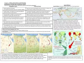
Category 1- History, Government, and Citizenship GEOGRAPHIC FACTORS AND HISTORICAL EVENTS Historical events affect and are affected by physical and human geography Spatial Diffusion Spatial diffusion: spread of a phenomenon from its starting location Geographic Factor Historical Event Native populations exhibited use of gold and practiced native (non-Catholic) religions Spain sent more conquistadors and missionaries to conquer and convert natives. Natives forced to labor in mines. Animals, plants, and disease in Europe were different than those found in Latin America. “Columbian Exchange” introduced new crops and animals to both regions. Old World diseases killed millions of natives. Small population available to provide labor for production of sugar, gold, and other work. Millions of Africans were forced to migrate to Latin America (one-third of all African slaves were sent to Brazil) Ideals of American and French Revolutions spread in Latin America. Spain and Portugal were occupied by France. Latin American colonies initiated wars for independence. New governments featured many authoritarian leaders (dictators) with military backgrounds. (Juntas) Example 1: The potato originated in the New World and with the “Columbian Exchange” it spread across the globe. Potatoes were extensively traded in the Andes before the European conquest. They were grown at high elevations, and taken either as fresh tubers or as chuño to other areas such as the coast. Potatoes were introduced into Europe by returning Spanish conquistadors during the second half of the 16th century. The top producer for potatoes today is China. One-third of all potatoes are produced in China and India. Russian Federation comes in third, Ukraine in fourth, with the U.S. in fifth place. New independent nations were divided physically (mountains, dense forests) and culturally. Revolts with nations, wars between nations and coups d ḕtat (government overthrows) were common. These geographic factors and historical events had a lasting impact on Latin America. Unlike the U.S. former colonies did not unite to form one country. Today, most Latin American countries have stable governments and cultures that combine, native, European, and African elements. Physical and Human Geography Over Time: The physical and human characteristics of a place change over time. Desertification is the degradation of land in arid, semi-arid, and dry sub-humid areas. It is caused primarily by human activities and climatic variations. The changing climate first attracted people to the Sahara as rainfall increased abruptly throughout the region beginning about 10,500 years ago (8,500 BC). Then increasing drought drove them southward into the modern Sahel as the rains became less frequent beginning about 7,200 years ago. By 5,500 years ago (3,500 BC) the Sahara had returned to full desert conditions. It appears that many who left the Sahara settled in the Nile valley about 5,500 years ago, setting the stage for the First Dynasty starting with the reign of King Narmer in 3,000 BC (5,000 years ago). Example 2: The spread of American pop culture items can be seen around the world. These maps above show the spread globally of different items that are associated with the U.S.
Voting Patterns and Political Boundaries Maps that show election results or political boundaries reveal how political power is distributed. Category 1- History, Government, and Citizenship, continued Changing Perceptions of Geographic Features Conflict, Cooperation, and Control Conflict and cooperation are processes used to control Earth’s surface. Example 1: NAFTA is an agreement between Canada, U.S. and Mexico that reduces or eliminates trade barriers among the countries. The countries cooperate to create the largest trading bloc in the world. Societies change as people’s perceptions of geographic features shift due to economic, technological, social, political or other changes. • Example 1: Clark County in Nevada did not attract many inhabitants for centuries. Limited water resources, flooding, and the desert climate limited development. Several changes shifted perceptions, resulting in a population increase from around 4,000 in 1910 to near 2, 000, 000 in 2010: • In 1936, Hoover Dam was completed (controls flooding, supplies water and hydroelectric power, and creates attractive Lake Mead). • In 1940’s, hotels and entertainment established tourism in Las Vegas. • In 1947, low-cost air conditioning window units became available. Example 2: OPEC is an intergovernmental body of oil exporting countries that hold 79% of the world’s known reserves. Cooperation benefits member nations. Map showing OPEC member nations Example 3: Violent ethnic conflict from 1991-1995 divided the former Yugoslavia, forming smaller nations. Example 4: At Berlin Conference in 1884, European nations cooperated to divide Africa into zones that each nation could colonize it. The nations rushed to establish colonies, conflicting with Africans if necessary to establish control. By 1902, 90% of Africa was under European control. Example 5: EU The European Union is a unique economic and political partnership between 27 European countries. It has delivered half a century of peace, stability, and prosperity, helped raise living standards, launched a single European currency (euro), and is progressively building a single Europe-wide market in which people, goods, services, and capital move among Member States as freely as within one country. Example 6: Israel and Palestine In 1947, the United Nations voted in favor of creating a Jewish state, but this proposal was rejected by Arab leaders. When Israel declared its independence in 1948, neighboring Arab states immediately declared war on Israel. Today, after several wars and shifting borders, Israelis and Palestinians are now debating the future borders of Israel and Palestine. One major issue is whether a new Palestinian state should include some part of the city of Jerusalem. Example 7: United Nations is an organization of all the sovereign nation states in the world. Founded after WWII, the aim of the United Nations is to promote peace, prevent war and encourage development in all nations. All members make up what is called the General Assembly. A group of especially powerful states, including the U.S., Russia, China, Britain and France, belong to the UN Security Council. The Security Council has the power to send UN peace-keeping forces to areas of conflict around the world. Geographic Factors, National Power, and International Relations A nation’s power to control territory and influence other nations is affected by physical and human geographic factors. 365- Obama 173-McCain 270 needed to win • Location: nations that connect with others to trade goods can grow their economies more than physically or politically isolated nations. • Example: Afghanistan is a poor country with a history of invasions. • It is landlocked in Asia at the crossroads of powerful, diverse • cultures. • Critical resources: economies depend on fuel, water, metals, and other resources; nations that control these resources are more powerful. • Example: Iraq’s oil production increases it international status, as • other countries must build relationships with Iraq to buy its oil. • Size: larger nations may have more resources and the potential for a larger population compared to a smaller nation. • Example: China boasts the world’s largest population and its • growing economy is transforming China into a world superpower. • Shape: compact nations can be easier to control and unify so that resources can be focused on improvements; nations that share borders or have well-defined (often natural) borders are advantaged. • Example: Both the United Kingdom and Japan are relatively small • island nations that became very powerful by reforming • government, industrializing quickly, and building a strong army and • navy. Electoral College map showing the results of the 2008 U.S. presidential election. Senator Barack Obama (D-IL) won the popular vote in 28 states and the District of Columbia (denoted in blue) to capture 365 electoral votes. Senator John McCain (R-AZ) won the popular vote in 22 states (denoted in red) to capture 173 electoral votes. Nebraska split its electoral vote when Senator Obama won the electoral vote from Nebraska's 2nd congressional district; the state's other four electoral votes went to Senator McCain. Public Policy Development, Citizenship, and Point of View Local, state/provincial, national, international governing bodies develop public policy. Different points of view influence public policy. Example: China’s one-child policy was implemented in 1978 to address overpopulation. Exceptions to the policy were made for rural couples and for parents with no siblings in response to their specific concerns. Cultural beliefs affect citizenship practices and public policy response. Example: Traditionally and economically, Chinese tend to favor sons. Citizens used family planning methods (often illegal) in response to the one-child policy. In 2000, the ratio of male to female births was 117:100.
Category 2: Geography PHYSICAL ENVIRONMENT AND PHYSICAL PROCESSES ANNUAL CHANGES IN EARTH-SUN RELATIONSHIPS Earth’s 23.5o tilt and annual revolution around the sun, cause changes in duration and intensity of sunlight at a given location throughout the year, resulting in seasons, weather phenomena, and geographic zones. • Earth’s physical environment or physical geography is often divided into four parts that can be used to describe different regions on Earth: • Lithosphere:land or rock part of Earth (including land under water) • Examples: mountain, plain, valley, continental shelf (area around a continent where • the ocean is not very deep), canyon, island, mesa. • Atmosphere: air (gases) that extend about 6,000 miles above Earth’s surface; air is about 78% nitrogen, 21% oxygen, and 1% other gases. • Hydrosphere: water in, on, and above Earth in all its forms. • Examples: groundwater, oceans, lakes, ice caps, water vapor, clouds. • Biosphere: parts of lithosphere, atmosphere, and hydrosphere that support life (living organisms like plants, animals, fungi, and bacteria). • Example 1: Northern Hemisphere’s summer solstice on June 20th/21st • Sunlight directly hits Tropic of Cancer • Longest day of year and beginning of summer in north; shortest day of the year and beginning of winter in south • Continuous daylight in Arctic Circle • Example 2: Between March equinox (sun passes over equator; equal lengths of day and night) and September equinox, greater solar energy in northern tropics causes wet season (by convectional precipitation). • Example 3: A hurricane is an extreme weather event that forms when air over a warm ocean warms up and gains a large amount of water vapor. Hurricanes originate in the tropics during summer and autumn. Sunlight • Many physical processes affect Earth’s physical geography: • Tectonic forces: lithosphere consists of large tectonic plates that move relative to each other; movement causes earthquakes and landforms, such as mountains and volcanoes, at plate boundaries. • Geographic zones (affect climate) are based on Earth-sun relationships: • tropical (low latitude): between Tropics of Cancer and Capricorn • polar (high latitude): north of Arctic Circle or south of Antarctic Circle • temperate (middle latitude): between tropical zone and polar zones CLIMATE weather:conditions (wind, precipitation, temperature, humidity) at a particular time and place; can change suddenly, hurricanes, floods, tornadoes, droughts, and blizzards are extreme weather phenomena climate: seasonal pattern of weather conditions in an area over many years; does not change suddenly; key factors result in climate regions. Transform boundary San Andreas Fault, California Factor Description Effect on Climate latitude degrees north or south of equator tropics are warm all year (sun drives convectional precipitation); (equator is 0o; north pole is 90o N, polar zones are cold all year, temperate zones are seasonal south pole is 90o S elevation height above sea level higher elevations are colder “ocean “rivers” within oceans that move warm ocean currents heat the air, increasing temperatures and currents” warm water from tropics or cold humidity (water in air); cold ocean currents can have reverse water from polar zones effect wind prevailing wind may blow over a wind from over water is humid; frontal precipitation occurs direction body of water or over land to a when a mass of warm, wet air meets a mass of cold air position on continent (temperate zones) mountain mountains force air up to pass over, orographic precipitation occurs on windward side of mountain barriers air cools and holds less water (leeward side is much drier) _____________________________________________________________________________________________ Example 1: Explain the Amazon rainforest’s tropical wet climate. Answer: It is located at low latitudes near the equator. The sun drives convectional precipitation year round by heating warm humid air in the morning. The air rises, clouds form, and rain falls in the afternoon. Example 2: Explain Mount Kilimanjaro's year-round ice cap. Answer: The mountain is near the equator with a tropical wet/dry climate at its base. The peak is at a high elevation, resulting in many different climates at different elevations along the mountain. Near the cap, there is a highland climate (alpine tundra) Example 3: Sweden has a much warmer climate (humid continental) than areas of Canada or Russia (subarctic) at same latitude. The North Atlantic current, a warm ocean current, moderates Europe’s climates. Example 4: The Coast of Chile has a marine west coast climate. Just inland, across a mountain range (the Andes), the climate is semiarid or arid. Orographic precipitation occurs on the windward (west) side. Subduction(Convergent) Andes Mountains, South America Collision-(Convergent) Himalaya Mountains- India, China Divergent boundary: Volcanoes, lakes- East Africa • Weathering: breaking down of rock into smaller pieces (sediment); forces that cause weathering include weather (wind, rain, flowing water) and freezing and thawing (water in rock’s pores expands when it freezes, putting stress on the rock and causing it to break apart. • Erosion: movement of weathered rock caused by gravity (as in landslides), water, wind or ice (such as glaciation). • Wave action: waves can be either can be constructive (add sediment to a beach) or destructive (remove, or erode, sediment from a beach. • Soil building: weathering, erosion, deposition can result in an accumulation of sediment; organic matter (humus), water, and air combine with sediment to produce soil that can support plant life. • LANDFORMS AND PHYSICAL PROCESSES • Physical processes form distinct landforms in the lithosphere • Examples:Weathering and erosion carve out canyons. Deposition of eroded sediment carried by a river forms a delta at the rivers mouth. Sediment from constructive wave action creates a beach. Wind then creates sand dunes. Tectonic forces create mountains, volcanoes,lakes, and trenches. Underwater volcanic eruptions can form islands.
__________________________________________________________________________________________________________________________________________________________________________________________________________ Region South Asia East Asia Southeast Asia Oceania/Australia_________ Country India China Indonesia Australia______________ ____________________________________________Physical_________________________________________________ Size (sg.km)3,287,263 9,596,961 1.904,569 7,741,220________________ Predominant tropical temperate tropical wet arid, semiarid Climates____________________________________________________________________________________________ Land/Use cropland, cropland, forest grazing, desert, Vegetation forest forest, grazing cropland_________________ Political & Economic ____________________________________________________________________________________________________ Government federal communist republic federal parliamentary Structure republic state democracy______________ GDP per capita $3500 $7600 $4200 $41,00_________________ % agriculture 16.1% 9.6% 16.5% 4%___________________ % industry 28.6% 46.8% 46.4% 24.8%_________________ % services 55.3% 43.6% 37.1% 71.2%________________ Oil Prod. (BPD) 879,000 3,991,000 1,023,000 589,200_______________ Social Cultural ___________________________________________________________________________________________________ Predominant Hindu 81% officially Muslim 86%,Catholic 3% Protestant 35%, Catholic Religions Muslim 13%atheist Protestant 6% 26% none 19%_________ Predominant Hindi 41%, Bengali 8%, Mandarin, others, BahasaIndonesia, Languages English, many Yue(Cantonese) English, Dutch English________________ Population 1,189,172,906 1,336,718,015 245,613,043 21,766,711____________ Pop. Density 400 /sq.km 140 /sq. km 135/sq. km 3/sq. km_____________ Growth Rate 1.344% 0.493% 1.069% 1.148%______________ Net Migration -0.05 -0.33 -1.15 6.03_________________ Urbanization 30% 47% 44% 89%________________ Infant Mortality 47.57 16.06 27.95 4.61________________ Life Expectancy M/F 65.77/67.95 72.68/76.94 68.8/73.99 75.92/80.93_________ Literacy M/F 73.4%/47.8% 95.7%/87.6% 94%/86.8% 99%/99%___________ wind direction DISTRIBUTION OF PLANTS AND ANIMALS Climate and soil determine vegetation (plant life) that grows in a region. ecosystem: mix of all living and non-living things, conditions, and interactions in an area; a biome describes the ecosystem of a region land use: human activity, such as farming or ranching; alters biomes Examples: A rainforest contains a huge variety of plant and animal life (high biological diversity). Tundra or desert biomes contain only plants and animals that have been adapted to the harsh conditions. Grasslands have been converted to grazing and cropland (fertile land, good soil).
Category 2 Settlements and Urbanization Settlements are often located along transportation routes or near natural resources (especially water), economic activities, other settlements. Cities: large population centers (commercial, industrial, and residential areas) Urbanization: growth of cities; fewer than 5% of people lived in cities two hundred years ago, but now more than half of all people live in cities. Example 1: The physical maps show modern cities in locations that were originally settled thousands of years ago. What features do they share? Answer: Alexandria, Beijing, Rome, and Istanbul are all located on bodies of water (river or coastal locations). All four cities were also located on ancient trade routes, such as the spice trade and the Silk Road
Categories 2, 3, & 4 – Geography, Culture, and Economics by Country Select geographic, cultural, and economic features are shown below for key countries from each world region. ________________________________________________________________________________________________________________________________________________________________________ Region U.S./Canada Latin America Europe Russia/Republics N. Africa/SW Asia Sub-Saharan Africa Country U.S. Canada Brazil Mexico France Poland Russia Turkey Iran Nigeria__________ Physical___________________________________________________________________________ Size (sq. km) 9,826, 675 9,984,670 8,514,877 1,964,375 551,500 312,685 17,098,242 783,562 1648,195 923,768___________ Predominant mostly temperate mostly tropical, temperate temperatetemperate, temperate, arid, tropical, Climates temperate subarctic tropical arid/semiarid subarctic semiarid semiaridsemiarid___________ Land Use/ cropland, forest,grazingforest,grazing grazing, cropland cropland, cropland, cropland, grazing grazing, Vegetation grazing,forest cropland croplandcropland forest grazing, forest grazing,forest cropland___________ Political & Economic_________________________________________________________________________________ Government constitutional parlimentary federal federal republic republic federation republican theocracy federal Structure federal republic democracy republic republic parliamentary republic___________ GDP per capita $47,200 $39,400 $10,800 $13,900 $33,100 $18,800 $15,900 $12,300 $10,600 $2,500____________ % agriculture 1.2% 2% 6.1% 4.2% 1.8% 4% 4.2% 8.8% 11% 31.9%_____________ % industry 22.2% 20% 26.4% 33.3% 19.2% 32% 33.6% 25.7% 45.9% 32.9%____________ % services 76.7% 78% 67.5% 62.5% 79% 64% 62% 65.5% 43.1% 38.9%____________ oil production 9,056,000 3,289,000 2,572,000 3,001,000 71,000 34,000 10,120,000 53,000 4,112,000 2,211,000_________ (BPD) Social/Cultural________________________________________________________________________________________ Predominant Protestant 51% Catholic 43% Catholic 74% Catholic 77% Catholic 85% Catholic 90% Orthodox 17% Muslim 99.9% Muslim 98% Muslim 50% Religions Catholic 24% Protestant 23% Protestant 15% Protestant 6% Muslim 8% (75% practicing) Muslim 12% Shia 89% /Sunni 9% Chr. 40% Indig.10% Predominant English 82% English 60% Portuguese Spanish French Polish Russian/many minority Turkish, Persian 58%, English, many minority Languages Spanish 11% French 22% languages Kurdish Turkish 6% languages___________ Population 313,232,044 34,030,589 203,429,773 113,724,226 62,814,233 38,441,588 138,739,892 78,785,548 77,891,220 155,215,573________ Pop. Density3 34/sq. km 4/sq. km 24/sq.km 59/sq. km 114/sq.km 126/sq. km 8/sq.km 182/sq.km 51/sq.km 170/sq.km_________ Growth Rate 0.963% 0.794% 1.134% 1.102% 0.5% -0.067% -0.47% 1.235% 1.935% 1.344%___________ Net Migration4 4.185.65 -0.09 -3.24 1.46 -1.47 0.29 6.51 -0.13 -0.1______________ Urbanization 82% 81% 87% 78% 85% 61% 73% 70% 71% 50%_____________ Infant Mortality3 6.06 4.92 21.17 17.29 3.29 6.54 10.08 23.94 42.26 91.54____________ Life Expect. M/F 75.92/80.93 78.81/84.1 68.97/76.27 73.65/79.43 78.02/84.54 72.1/80.25 59.8/73.2 70.61/74.49 68.58/71.61 46.76/48.41________ Literacy M/F 99%/99% 99%/99% 88.4%/88.8% 86.9%/85.3% 99%/99% 99.8%/99.7% 99.7%/99.2% 95.3%/79.6% 83.5%/70.4% 75.7%/60.6%_______ Category 2- Geography HUMANS AND THE PHYSICAL ENVIRONMENTHumans depend on and adapt to, and modify the physical environmExample 1: Around 30,000 B.C., Beringia formed a land bridge between Siberia and Alaska. Humans are believed to have followed herds of animals, migrating to North America. Their descendants include the Inuit, who live today in Arctic portions of Canada. Inuit survive in the Arctic by using sleds for transportation, fishing, and hunting for food, using animal skins for clothing and footwear, and making winter homes (igloos) from snow. Example 2: In the Sahara, nomadic Taureg people have adapted to the harsh desert climate by using camels for transportation, raising livestock for food, using tents for temporary shelter, and trading food and goods. Example 3: For thousands of years, people in the Andes Mountains of Peru, including the Inca and their descendants, have raised llamas for transportation, wool, and meat. Llama dung may have been important for growing maize (corn), which supported some of the world’s first cities. DEFINING GEOGRAPHIC REGIONS Formal Regions: defined by characteristic(s) that the whole region shares. Example: Australia’s outback is arid and has few people (<2/square mile). (Latin America is a formal region) Functional Regions: defined by a focal point and the areas connected to it. Example: Houston metropolitan area includes the city and many suburbs. (They include roads, infrastructure) Perceptual Regions: defined by people’s feelings about an area. Example: “Eastern Europe” is defined differently by different people. (Texas can be part of the South or West depending on the persons view)
Example: Physical, political, social/cultural, and economic features shape the character of a place. Using the tables, what are some differences between Australia and Canada? Answer: Australia and Canada have many similar features. However they differ in climate (latitude), land use or vegetation, and oil production. Also, in certain provinces of Canada, the dominant language is French instead of English.
Category 2- Geography Human Migration migration- movement of people from one location to another; physical geography affects routes (paths), flows (numbers), and destinations. push-pull factors- push factors are reasons for leaving the starting location; pull factors are reasons people are attracted to the destination. Type Common Push Factors Common Pull Factors Political war, genocide, persecution, peace, protected freedoms discrimination, limited rights, and rights (political, involuntary migration religious, and personal) Example: An estimated 12 million Africans were forcibly transported across the Atlantic to the Americas in the 16th and 19thcenturies. (push) Economic high unemployment, poor job opportunities, good living living conditions and medical conditions and medical care, care, financial instability financial stability Example: During England’s industrial revolution people left rural areas to find jobs: city-dwellers grew 6% in 1700 to 80% by 1900 (pull) Social discrimination, bullying, family/cultural connections, improved limited chance to marry chance to marry Example: Mormons fled bullying to settle in Utah in 1847. (push) By 1905 , over 90,000 foreign Mormons converts had lived in Utah (pull) Environmental natural disaster, man-made attractive climate, better natural disaster, pollution, climate resources Example: About 400,000 Ukrainians had to relocate to safer areas after a nuclear plant meltdown Contaminated a large area around Chernobyl POPULATION CHARACTERISTICS population density: measure of “crowdedness”; inhabitants per unit area Example: Taiwan and Australia each have around 23 million inhabitants, but the population density in Taiwan is much higher. Australia has vast arid and semiarid areas where few people choose to live. birth rate: number of live births per 1,000 people mortality rate: number of deaths per 1,000 people (death rate) growth rate: birth rate minus mortality rate (rate of natural increase) population pyramid: shows population details (usually age and gender) Example 1: Egypt, 2011 Example 2: Japan, 2010 The pyramid shape of Egypt indicates a developing nation. Egypt’s population is young. Its future growth will be greater than Japan. The pyramid shape of Japan, indicates a developed nation. INTERRELATIONSHIPS AMONG PHYSICAL & HUMAN PROCESSES The geographic characteristics of a place are interdependent. Each process affects and is affected by the other processes. Example: Population growth slows once industrialization occurs due to declining birth rates. Europe’s share of the world population has dropped from over 21% in 1950 to less than 1% in 2010. WORLD POPULATION GROWTH AND DISTRIBUTION Fossil evidence suggests modern humans lived in Africa over 200,000 years ago. World Population: Growth and Key Events Hazardous Environmental Conditions Floods, droughts, fires, Hurricanes, and weather changes such as El Niño change the environment. Example: When rivers overflow, property and lives may be lost. However, flooded land often benefits from the addition of nutrients & sediment to the soil & revovers over time. Common weather effects of El Niño Common weather Effects of La Niña GEOGRAPHICAL DATA ANALYSIS Example: Drought may have increased Botswana’s child mortality rate in 2005 (HIV infections peaked in 2003)
Categories 2 & 3- Geography and Culture by World Culture Region Region Largest Nations within Region, Ordered from Largest Population to Smallest Population_______________________________ U.S./Canada United States; Canada_____________________________________________________________________________________ Latin America Brazil; Mexico; Columbia; Argentina; Peru; Venezuela; Chile; Ecuador; Guatemala; Cuba; Bolivia; Dominican Republic; Haiti____ Europe Germany; France; United Kingdom; Italy; Spain; Poland; Romania; Netherlands; Portugal; Greece; Belgium; Czech Republic____ Russia/Republics Russia; Ukraine; Uzbekistan; Kazakhstan; Belarus; Azerbaijan; Tajikistan; Kyrgyzstan; Turkmenistan; Georgia; Moldova________ N Africa/SW Asia Egypt; Turkey; Iran; Algeria; Morocco, Iraq; Afghanistan; Saudi Arabia; Yemen; Syria; Tunisia; Israel; Libya; Jordan____________ Sub-Saharan Africa Nigeria; Ethiopia; Dem. Rep. of the Congo; South Africa; Sudan; Tanzania; Kenya; Uganda; Ghana; Mozambique; Madagascar__ South Asia India; Pakistan; Bangladesh; Nepal; Sri Lanka; Bhutan; Maldives____________________________________________________ Southeast Asia China; Japan; South Korea; North Korea; Taiwan; Hong Kong; Mongolia; Macau_______________________________________ Oceania/Australia Australia; Papua New Guinea: New Zealand; Fiji; Solomon Islands; French Polynesia; New Caledonia; Vanuatu; Samoa_______ Example 1: Women and religious minorities are treated differently in different regions. One measure of economic opportunities for women is the difference between male and female literacy rates. Which regions have almost no difference between male and female literacy rates? Answer: U.S./Canada, Latin America; Europe; Russia/Republics; Oceania/Australia. Example 2: The standard of living in a nation depends on a blend of political, economic, and social/cultural factors. Which regions have more people moving into than out of them? Answer: U.S./Canada, Europe, Oceania/Australia (+ net migration rates). Example 3: Taiwan is a 35,980 sq. km island near China. Cuba is a 110,860 sq. km island near the U.S., located at a similar latitude. Taiwan has a market economy (free enterprise), whereas Cuba has a command economy that is isolated from the U.S. Cuba’s isolation and its economic structure may affect its productivity (GDP), innovation rates, and diffusion rates of new ideas and behaviors. ________________________________________________________ Nation Cuba Taiwan____ GDP per capita $9,900 $35,700___ Exports (millions) $3,311 $274,600 _ Imports (millions) $10,250 $251,400_ Merchant Marine Fleet (commercial) 5 101_____ Example 4: South Asia is religiously diverse, but most South Asian nations are dominated by a single religion. ____________________________________________________________________ Nation India Pakistan Bangladesh Nepal Sri Lanka__ DominantReligion Hindu MuslimMuslim Hindi Buddhist_ % 81% 95% 90% 81% 69%_____ Living conditions in an area can change dramatically due to political, economic, social, and environmental (natural and human-caused) changes. Example: Desertification in the Ethiopian Highlands transforms arid or semi-arid land with productive value (grazing, farming) into desert. Over-grazing, a lack of rain, and possibly global warming have expanded desertification and resulted in economic hardships, social changes, and political unrest in Ethiopia. Category 3- Culture Cultural Viewpoint Example: People from Catholic Mexico, Islamic culture- behaviors and ideas shared by a group of people, language, (Shia) Iran, or post-Christian Western religion, land use, education level, political system, and customs contribute Europe may judge other religions to a region’s distinct character. quite differently based on their different point of view- different groups of people view cultures differently. Religious perspectives.
PROCESSES OF CULTURAL CHANGE A culture changes when new ideas, behaviors, and technologies are adopted. People may or may not be motivated to adopt a new idea or behavior. Example: Few Jews converted to Catholicism in Poland during the 17th and 18th centuries, despite efforts by the Catholic Church. The Jewish community and Christian community maintained distinct cultures and there was limited motivation on the part of Jewish people to convert. independent invention- idea, behavior, or technology originates within culture. Example: Writing was invented and adopted by the Sumerians in Mesopotamia (modern-day Iraq) around 3500 B.C. The Olmecs of ancient Mexico also developed writing independently around 400 B.C. diffusion- idea, behavior, or technology spreadsfrom another culture(s) Process Examples of Diffusion and Adoption migration Spaniards brought horses when they migrated from Europe to North America. Plains Indians began to use horses for hunting buffalo, warfare, and transportation by the mid 1600’s._____________________________________ War The Korean War resulted in a strong U.S. military presence in South Korea. Beginning in the 1950’s, South Koreans near U.S. bases often learned English. American television and radio programs affected South Korean styles and tastes______________________________________________________________________________ trade Indian merchants brought Indian cuisine to Southeast Asia.___________________________________________ Category 4- Economic, Science, Technology, and Society Traditional, Command, and Market (Free Enterprise) Economies traditional economy: goods and services are traded without exchanging money; also called “barter system”; common in undeveloped areas. command economy: government controls the production (and often the distribution) of goods and services; also called “planned economy” market economy: voluntary participation by producers and consumers; consumer demand production; “capitalism” or “free enterprise” PRODUCTION METHODS FOR FOOD AND BASIC GOODS People use different methods to get food and goods to meet their needs. Method: subsistence agriculture: food is mostly consumed by farm family. Example: A family on a small farm in Asia raises a variety of crops and animals to meet its needs. A small amount is traded or sold to get basic needs not produced by the family, such as salt or tea. Market-oriented agriculture: food is mostly sold to others. Example: Using modern technology, a large Canadian farm produces a huge wheat crop which is sold to a broker. cottage industry: individual makes goods in his or her home. Example: Before the Industrial Revolution in England, many women would spin and weave wool into cloth in their homes. The business operator would bring them raw wool, take the cloth, and pay per piece. commercial industry- employees come to central location(s) and use the companies equipment, resources. Example: A modern textile factory in Pakistan has many employees and combines yarn, knitting, fabric dyeing, processing, laundry, apparel manufacturing, and export facilities to make and ship textiles. As a nation develops market-oriented agriculture, commercial industry, and its infrastructure. GDP gross domestic product, total value of all goods or services produced) also increases. One measure of a nation’s economic development level is per capita GDP (GDP per inhabitant). CULTURAL PATTERNS AFFECTING INNOVATION AND DIFFUSION By examining the history of innovation and diffusion across cultures, patterns emerge that reveal cultural factors affecting these processes. Factor Impact of Innovation and Diffusion freedom of expression encourages open exchange and debate of ideas economic freedom fast-moving markets spur innovation and change access to education provides skills to create and evaluate ideas Inter-cultural exchanges exposure to more ideas; share and modify ideas Example: Large cities, cultural diversity, an international border, protected individual rights, and a university and corporate emphasis on technology have spurred fast cultural change in Texas through innovation and diffusion. DYNAMIC (CHANGING) AND STATIC (TRADITIONAL CULTURES The rates of cultural change varies between cultural groups and regions Example 1: The U.S. and Canada culture region is often an early adopter of new behaviors and ideas, such as democracy, new technology and pop culture. Amish people who live there purposely maintain traditional ways, however, using windmills, horse-drawn carriages, and hand sewn clothing. Example 2: Brazil’s language is Portuguese and it is largely Catholic, due to colonization by Portugal. Brazilian food, art, and music are strongly influenced by native and African culture. Some indigenous groups in the Amazon rainforest have maintained their separation from the Brazilian culture and live traditionally as hunters and gatherers. CULTURAL CONVERGENCE AND DIVERGENCE cultural convergence- process by which cultures grow more alike (similar) Example 1: The spread of democratic ideas (equal political rights and protected civil liberties) had made the cultures of diverse nations that adopt these ideas and behaviors (examples include Canada, Costa Rica, New Zealand, Micronesia, Estonia, Norway, and Cyprus) more alike. Example 2: Communicating through translators is inefficient. Scientists and business people use English for many international communications. Example 3: U.S. fast food chains, such as McDonalds, are expanding quickly in Eastern Europe and Russia. The European furniture store, IKEA, is quickly growing in the U.S. Globalization can lead to cultural convergence. cultural divergence- process by which cultures grow apart (less alike) Example: China and Taiwan share the same language, and the majority of Chinese and Taiwanese people are the same ethnicity. After the 1949 Communist Revolution, however, the two countries diverged politically, socially, and economically in many ways. Taiwan became democratic, capitalism fueled economic growth, and dramatic social change resulted.
Category 4- Economics, Science, Technology, and Society LOCATION AND PATTERNS OF ECONOMIC ACTIVITIES The location where a certain type of economic activity takes place depends on many factors. It is important for some businesses to locate near their customers. Other businesses benefit more from locating near certain resources. For others, access to low-cost transportation (such as a seaport, railroad, or highway) is most critical. Example: Paper mills are located near timber resources to minimize the cost of transporting cut trees to the mill. Mills often negotiate with railroad companies to get a rail line at the mill for shipping out paper. Changes can shift the locations and patterns of economic activities. Change Example technological At the start of the Industrial Revolution, most factories were located along rivers so that flowing water could power the machines. The steam engine broke this pattern by enabling factories to be built anywhere. transportation Transportation costs limited the location of many economic activities. The expansion of railroads allowed the low-cost shipment of goods over long distances, allowing businesses to located along rail lines further from markets, suppliers, and resources. communication The invention of the internet (world wide web) has allowed online businesses to find customers anywhere. • GLOBAL TRADE PATTERNS OVER TIME • Global trade patterns have taken many different forms over time: • Silk Road: ancient overland trade route that extended from China to the Mediterranean Sea; trading caravans carried silk, spices, and other materials over 4,000 miles from 100 BC until the 15th century • European maritime spice trade: Ottoman Turk Empire blocked overland trade routes to Europe in 1453; Portugal developed a sea trade route to India around the southern tip of Africa which replaced the Silk Road. • triangular trade: slaves were transported from West Africa to New World (colonial) ports; cash crops were transported from colonies to Europe; European finished goods were sent to Africa (and colonies) • modern trade patterns: many corporations make goods by gathering materials from certain countries, making basic parts in other countries, completing assembly in yet another country, and shipping finished goods to countries throughout the world (using modern technologies) GLOBAL DISTRIBUTION OF RESOURCES The available resources in a place affect the movement of products, people, and capital (money) into or out of it. Example 1: Kuwait is a small nation in the Middle East with poor land for crops and limited water. In 1938; its small pearl-diving economy was changed forever by the discovery of oil. Investment capital and people flowed into the country, petroleum and service industries expanded, and GDP grew. Today, Kuwait is a rich nation that exports petroleum Products and imports food and other goods. The majority of the inhabitants are non-Kuwaiti. Example 2: Puerto Rico is a territory of the U.S. comprised of several islands in the Caribbean. Because of its limited natural resources, many Puerto Ricans migrate to the U.S. in search of jobs. RESOURCE USE POLICIES AND REGULATIONS The more valuable a resource is at a certain location, the more likely it is to be regulated to control its development and distribution. Example: Water is scarce in Israel. To provide for current needs and plan for future needs, the production and use of water is regulated by The Water Commission: “The water resources of the State are public property; they are subject to the control of the State… “Taxes, pricing, and other laws control water use in homes, businesses, and farms.
TECHNOLOGICAL INNOVATIONS AND THE PHYSICAL ENVIRONMENT Humans have used major innovations to modify the environment Innovation Effect on Physical Environment fire Early humans used fire for heat, light, protection, and cooking. Fire expanded human locations and populations. About 5,000 years ago, humans began to use fire to make metal tools, enabling them to do more work and to change the environment (farms, ranches, logging). Today, firewood usage has eliminated woody plants in some undeveloped areas and “slash and burn” agricultural practices convert raw land (like rainforest) into temporary farmland. Burning also adds gases and particulates to the atmosphere. steam power Steam power expanded transportation (ships, trains) and the production of raw materials (mining, pumped water) and goods. This allowed humans to meet their needs and populate more places. It also transformed the environment by converting more raw land to human uses (logging, agriculture, mining, and urban areas) and adding gases and particulates to the atmosphere (from burning coal) diesel Diesel fuel is produced from crude oil. It stores a lot of energy and can be easily transported. This innovation led to automobiles and changes to the environment (crude oil machinery production, petroleum refining, road construction, population booms near oil resources, and atmospheric changes). electricity Electricity allowed power produced at one location to be transmitted over wires to distant locations. It further expanded the locations of human populations and activities. The burning of fossil fuels (coal, gas) to produce electricity adds gases and particulates to the atmosphere. • TECHNOLOGICAL INNOVATIONS AND PHYSICAL PROCESSES • Innovations protect people and property from physical processes: • floods: dam construction, dikes, water pumps, prediction models • hurricanes: seawalls, building codes, prediction/warning systems • earthquakes: building codes and public works construction codes. TECHNOLOGY, MARKETS, AND PERCEPTION OF RESOURCES New technology and markets change people’s perception of resources. Example: The digital and communications revolution connects people and dramatically increases the rates of diffusion and innovation. GDP can be grown dramatically by capable people using information as a resource. Educated, productive people may be perceived as a nation’s most valuable resource (instead of a large supply of gold or crude oil). Technology, Primary Economic Activities, and the Environment Primary economic activities: extraction of raw materials from Earth, such as farming, ranching, mining, logging, fishing, quarrying, and hunting. Example: Technology (like pesticides and genetically modified seeds) enables farmers to increase food supply while farming the same amount of land. Pesticides and fertilizers add chemicals to the environment. Social Studies Skills POLITICAL UNITS Borders define political units, such as cities, states, and countries. man-made border: artificial border created by humans; often follows a line of latitude (horizontal division that defines a distance north or south of the equator) or a line of longitude (vertical division that defines a distance east or west of the prime meridian in Greenwich, England) Example: Great Wall of China- borders China and Mongolia natural border: border based on the physical environment, such as a body of water (sea, river, lake) or a mountain range. Example: Rio Grande River is the border between the U.S. (Texas) and Mexico. Social Studies Skills MAPS AND GEOGRAPHIC INFORMATION Maps can be created to show many types of geographic information. Example: Egypt and Southwest Asia: Distribution of Religions. Question: In which country is there a Shia Muslim (Islamic majority)? Answer: Iran STATISTICAL ANALYSIS OF GEOGRAPHIC DATA Spreadsheets and statistical software can be used to analyze geographic data in order to better understand a situation or data set. Term Description frequency number of occurrences in a given period of time_ range largest number minus smallest number_________ mean sum of values divided by the number of items____ median middlemost number in an ordered list of numbers Mode most frequent number in a list of numbers_______ Example: The median GDP per capita may relate to the standard of living in a country more directly than the mean GDP per capita. The middlemost number will not be skewed by the presence of outliers, such as a small population of people whose income is extremely high. HISTORICAL, GEOGRAPHIC, AND STATISTICAL INFORMATION SOURCES A variety of sources can be used to find historical, geographic, and statistical information, including government and media-produced reports, databases, interviews, and polls (results of questionnaires) Example: In what ways are the Ukraine and the U.K. similar? Nation Ukraine United Kingdom____________Answer: The two countries share Coordinates 49N, 32E (at center 54N, 2W (at center)_________ similar latitudes (49N vs. 54N), Size 608,550 sq. km 243,610 sq. km_____________ populations (45,134,707 vs. Population 45,134,707 62,698,362________________ 62,698,362), and literacy rates Urbanization 69% 80%______________________ (99.4% vs. 99%). Religion Ukrainian Orthodox Kyiv 50% Christian (various, many Ukrainian Orthodox Moscow nominal) 71.6%;Muslim 2.7% 26%, Christian (other) 20%__________Hindu 1%, other 1.6%_______ Language Ukrainian 67% ;Russian 24% English, many recognized languages________________ Literacy 99.4% (total population) 99% (for total population____ GDP per capita $6,700 $34,800__________________ CASE STUDIES AND GEOGRAPHIC INFORMATION SYSTEMS case study: detailed investigation and presentation that focuses fully exploring or describing a particular situation, event, person, or group; the scope is usually narrow and generalizations are avoided (generalizations require multiple case studies and large sample sizes) geographic information system (GIS)-system that allows data to be connectedto its corresponding location; key tool for geographers.