Download
1 / 18
190 likes | 449 Vues
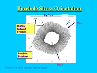
Designing Borehole IP Surveys. By Joe Mihelcic, Geophysicist ClearView Geophysics Inc. Ontario Exploration & Geoscience Symposium “New Ideas, Revisiting Past Discoveries” December 7, 2010. What is Borehole IP (BHIP)?. Any induced polarization survey that utilizes boreholes to:

E N D
Designing Borehole IP Surveys By Joe Mihelcic, Geophysicist ClearView Geophysics Inc. Ontario Exploration & Geoscience Symposium “New Ideas, Revisiting Past Discoveries” December 7, 2010
What is Borehole IP (BHIP)? • Any induced polarization survey that utilizes boreholes to: • Inject current or • Measure potentials
When is BHIP applied? • Most common scenario is that favourable mineralization intersected in at least one borehole: • Test if target is chargeable • Quantify in or around borehole • Determine Orientation/Direction/Extents • Prioritize available geophysics and drilling data
How to achieve this with BHIP? • Many configurations and methods available: • Mise-a-la-masse • In-hole Pole-dipole and dipole-dipole • Hole-to-hole • Gradient • Etc. etc.
Designing BHIP surveys • Keep it simple • Configure using basic physics • Include external data • Consider cost/risk vs. benefit/reward • E.g., tomographic mode for mineral exploration?
Example: • Favourable mineralization detected in a number of boreholes spread over wide area • Favoured theory suggests overall mineralizatoin plunges towards the northwest • Attempt BHIP to test this theory from borehole with good intersection • 158.2 m -193.6 m
Step 1 • Run a simple dipole-dipole detection log to determine if intersected zone is chargeable:
Step 2 • Charge the target zone with Current Electrodes above and below the zone: • C1 = 162 m (VG at 176 m) • C2 = 225 m • Read potentials on surface • Ensure lines at 90 degrees to BH direction • Tie-in to surface BH’s (bush crash)
Step 2 • Axis ‘A’ identified along chargeability trend
Step 2 • Axis ‘A’ identified along chargeability trend
Step 3 • Compare to available geophysics data
Step 3 • Compare to available geophysics data
Step 3 • Compare to available geophysics data
Step 4: • Focused post-processing of previously acquired surface pole-dipole geophysics data • Inversion modeling • Overlay drilling locations in 3D
<ANIMATION> - Not available on website download due to size - Available upon request
Step 5: • Which boreholes drilled through zone? • Re-examine logs to find anomaly source • Recommend tighter drilling along source axis if favourable intersections already encountered
Conclusions: • BHIP requires more customization than standard surface arrays • Inversion modeling useful in some cases, at end of process, especially for 3D visualization • A method to further prioritize surface IP results