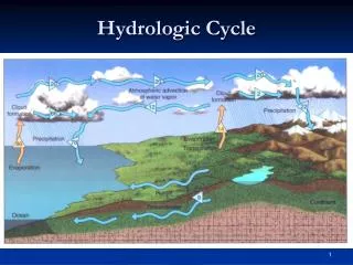
Hydrologic Cycle
Hydrologic Cycle. and permeability. Sand porosity. Fig. 19.06. Shallow aquifer. W. W. Norton. Confining bed/ aquitard. Deeper aquifer. Fig. 19.07 a. Unsaturated zone. HUMID CLIMATE. Fig. 19.11. W. W. Norton. Important to identify recharge areas!!!! Do not pollute them!.

Hydrologic Cycle
E N D
Presentation Transcript
and permeability Sand porosity
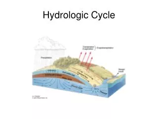
Fig. 19.06 Shallow aquifer W. W. Norton Confining bed/ aquitard Deeper aquifer
Fig. 19.07 a Unsaturated zone
HUMID CLIMATE Fig. 19.11 W. W. Norton Important to identify recharge areas!!!! Do not pollute them!
Losing stream ARID CLIMATE
Fig. 19.13 W. W. Norton
Determine which way Groundwater flows Determine location of Recharge/discharge areas
Fig. 19.15 a W. W. Norton
Fig. 19.15 b W. W. Norton
Fig. 19.15 c W. W. Norton
Fig. 19.22 a, b W. W. Norton
South Florida before pumping South Florida after pumping
AQUIFER TYPES Fig. 19.06 W. W. Norton Confining bed
Confined/artesian aquifer Note: aquiclude = confining bed!
The potentiometric surface is a pressure surface It’s the level to which water will rise in your well! Fig. 19.16 c W. W. Norton
Fig. 19.09 W. W. Norton
Unit Conversions Common units used to measure water are: • cfs (cubic feet per second) • gallons • acre-foot • inches (in precip gage) Need to be able to convert between them
Acre-foot 1 acre-foot = 43,560 ft2/acre x 1 foot = 43,560 ft3 How many gallons is this???
Cubic feet gallons • 7.48 gallons = 1 ft3 • 43,560 ft3 x 7.48 gal/1 ft3 = 325,829 gal
12 inches x 12 inches = 144 in2 Length-Area-VolumeL vs. L2 vs. L3 12 inches 1 ft2 =1 ft2 12 inches
Length-Area-VolumeL vs. L2 vs. L3 12 inches 1 ft3 12 in x 12 in x 12 in = 1728 in3 = 1 ft3 12 inches 12 inches
CRATER LAKE Surface area = 579,348,000 ft2 Avg. ann. Precip = 68 in. What volume of precip. is added to the lake in acre-feet each year? • Need to convert units to make • them consistent. It’s easiest to convert • Feet to acre-feet, so let’s convert inches to • Feet! • 68 in x 1 foot /12 inches = 68/12 feet = 5.67 ft • 2) Calculate volume of precip. in ft3 by • multiplying Surface area of lake x depth • of precip. • 579,348,000 ft2 x 5.67 ft = 3,284,903,160 ft3 • 3) Convert ft3 to acre-ft • 3,284,903,160 ft3 x 1 ac-ft/43,560 ft3 = • 75,411 acre-ft/year from ppt.