Hydrologic cycle`
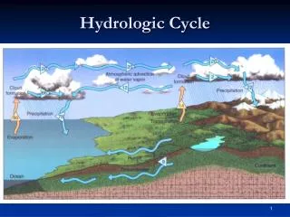
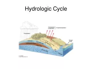
Hydrologic cycle`. I. Hydrologic Cycle: the movement of water through and over the Earth Water continuously traveling between oceans, atmosphere, continents, and mantle (by subduction and volcanism) . Hydrologic Cycle. I. Hydrologic Cycle: the movement of water through and over the Earth


Hydrologic cycle`
E N D
Presentation Transcript
Hydrologic cycle` I. Hydrologic Cycle: the movement of water through and over the Earth Water continuously traveling between oceans, atmosphere, continents, and mantle (by subduction and volcanism)
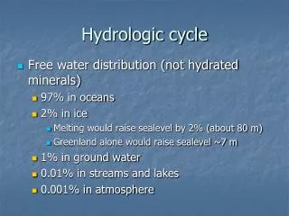
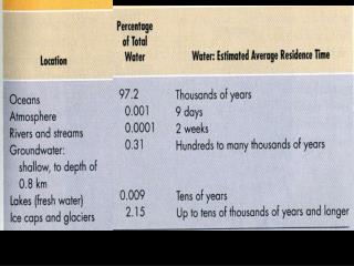
Hydrologic Cycle I. Hydrologic Cycle: the movement of water through and over the Earth 97.2% oceans 2.15% glaciers 0.62% groundwater 0.009% freshwater lakes 0.008% saline lakes & inland seas 0.005% soil moisture 0.001% atmosphere 0.0001% rivers First we’ll examine streams and then groundwater
97.2% oceans 2.15% glaciers 0.62% groundwater 0.009% freshwater lakes 0.008% saline lakes and inland seas 0.005% soil moisture 0.001% atmosphere 0.0001% rivers Hydrologic cycle
Streams II. Stream Terminology A. Stream (interchangeable with river): any surface water whose flow is confined to a channel. B. Floodplain: the flat land immediately surrounding a stream channel, which would be submerged if the stream were to overflow it’s banks (wider in valleys than mountains)
Streams II. Stream Terminology C. Headwaters (Head): the origin or the source water of a particular stream D. Mouth: the point downstream where the rivers empties into another body of water E. Tributaries: smaller streams which supply water to a larger stream F. Trunk Stream: a large stream into which smaller streams carry water and sediment
Streams II. Stream Terminology G. Distributaries: one of a network of small streams carrying water and sediment from a trunk stream into an ocean (located at the mouth of a stream) H. Watershed or Drainage Basin: the total area which feeds a particular stream Every stream, no matter how small, has a watershed (an area that it drains) Square mile area drained by a small tributary Mississippi River, 1.25 million square miles basin
Streams II. Stream Terminology I. Drainage Divide: area of higher topography which separates one watershed from an adjacent watershed For example, Rocky Mountains divide watershed of Mississippi from that of the Colorado River Or a low ridge dividing the watersheds of two tributaries The most important drainage divide in North America is the Continental Divide. The divide separates streams that flow to the Atlantic from those that flow to the Pacific.
Streams II. Stream Terminology I. Drainage Divide: area of higher topography which separates one watershed from an adjacent watershed
Streams III. Stream Flow A. Velocity: the distance the water travels in a given amount of time (varies greatly). Affects a streams ability to erode and transport material. Straight channel: fastest in the center, just below the water’s surface. Curved channel: fastest at the outside of the curve, just below the water’s surface.
Streams • III. Stream Flow • Velocity • Depends on: • 1. Gradient: slope of the stream, or it change in elevation over a given horizontal distance • Changes within a given stream, usually higher gradients near the headwaters, and gentler gradients at the mouth (general concave-up profile). • All else being equal: • steeper gradients = faster stream • 66 m/km to 0.1 m/km • Gradients are measured as vertical drop per horizontal distance)
Streams • III. Stream Flow • Velocity • Depends on: • 2. Size andShape of the stream channel • Slowest at the bottom and sides due to friction • Slightly slowed at the surface due to friction with the atmosphere
III. Stream Flow • Velocity • 2. Size andShape (continued) • Wetted perimeter: in cross section, the measure of the amount of surface contact between the water in a stream and it’s channel • Faster: small wetted perimeter : cross-sectional area (narrow & deep) • Slower: large wetted perimeter : cross-sectional area (wide & shallow) • When a given stream channel narrows, the stream must move faster • Analogy: put your thumb over a hose Streams
Streams • III. Stream Flow • Velocity • 3. Roughness of channel • Slower over rough bed (large boulders). • Water bounces around more, energy put into upward, side-ways and up-stream directions, typically headwaters • Faster over smooth bed (clay, sand), typically further down
Streams • III. Stream Flow • Velocity • 3. Roughness of channel
III. Stream Flow • Velocity • B. Discharge • The volume of water passing a given point on the stream bank per unit of time • Measured as cubic meters per second) • 1. Formula for hypothetical rectangular stream channel: Discharge = width x depth x velocity
III. Stream Flow • Velocity • Depends on: • B. Discharge • 2. Discharge also depends on: • a. size of drainage basin • b. amount of precipitation • Varies on daily cycles and seasonal cycles • 3. In a given stream, discharge increases from head to mouth • 4. Amazon: >12 times higher than Mississippi • One day discharge is equal to New York cities water needs for >5 years! Streams
Problem Set 3 • Due Monday, March 6th at beginning of class • Go to www.geology.cwu.edu and enter 101 in left navbar search field. • On G101 web page, download Problem Set #3, PDF file. • Discharge, stream velocity, wetted perimeter • Simple calculations • Need to understand units of calculations (e.g., m/sec or m3/sec)
Streams • IV. Stream Erosion • Most important geologic agent of surface change: they can erode, carry, and deposit sediment • Processes of Erosion: faster stream = more erosion • 1. Abrasion: scouring of the stream bed by transported particles • Fine particles suspended in the water constantly scrape the bed • Large pebbles my swirl in local eddies, carving out circular depressions called potholes
Streams • IV. Stream Erosion • Processes of Erosion • 2. Hydraulic lifting (erosion by water pressure) • Fast, turbulent water dislodges and lifts particles from the channel into the stream • Water forced into cracks with enough pressure to pry up rocks • 3. Dissolution • Water may dissolve underlying rock • For example: limestone or evaporites
Streams IV. Stream Erosion B. Base Level: the lowest level to which a stream can erode its channel The level at which the mouth of a stream enters the ocean, lake, another stream Ultimate base level = sea level Local or Temporary base level = lakes, main streams, dams, Or resistant layer of rock = waterfalls created, base level is lower on other side of rock Headwaters: are way above base level actively eroding, downcutting Near mouth: close to base level with less downward erosion, more side to side erosion
Streams IV. Stream Erosion C. Valley Geometry 1. Narrow: usually more toward head of stream = high gradients) Where streams are high above base level = more down-cutting Streams cut straight down into the underlying rock form valleys with vertical walls Usually V-shaped due to overland flow and mass movements removing loosened material on the slopes
IV. Stream Erosion C. Valley Geometry 2.Wide: usually toward the mouth of the river = lower gradients Once a stream has cut near to base level: energy directed to side to side erosion Widening of valley creates flood plain, either erosional or depositional
Streams IV. Stream Erosion C. Valley Geometry 3. Channel patterns: a. Meandering Stream Current fastest on outside of river bend - actively erodes cut bank Current slowest on inside of bend - deposits load and creates a point bar deposit
IV. Stream Erosion Current fastest on outside of river bend - actively erodes cut bank Current slowest on inside of bend - deposits load and creates a point bar deposit
Streams IV. Stream Erosion C. Valley Geometry 3. Channel patterns: a. Meandering Stream Meanders progressively get more pronounced Finally only separated by a thin strip Stream may form a cutoff Abandoned meander becomes an oxbow lake
Streams IV. Stream Erosion C. Valley Geometry 3. Channel patterns: b. Braided Stream Networks of converging and diverging stream channels Separated by narrow sand and gravel bars Develop in steams with very high sediment loads More sediment load than its carrying capacity
Streams IV. Stream Erosion C. Valley Geometry 3. Channel patterns: b. Braided Stream Deposit their load in the stream bed build up until they’re islands Occurs: Where stream banks are loose unconsolidated material (lack vegetation) or Where slope of stream decreases suddenly, base of mountain, steep tributary flowing into a gentle gradient main stream End of glacier = abundance of glacial sediments