Download
1 / 22
260 likes | 485 Vues
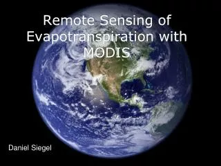
Remote Sensing of Evapotranspiration with MODIS. Daniel Siegel. What is MODIS?. Moderate-Resolution Imaging Spectroradiometer Launched in 1999 aboard the EOS AM (Terra); EOS PM (Aqua) followed in 2002 Monitors 36 spectral bands between 0.4 m and 14.4 m Images entire Earth

E N D
Remote Sensing of Evapotranspiration with MODIS Daniel Siegel
What is MODIS? • Moderate-Resolution Imaging Spectroradiometer • Launched in 1999 aboard the EOS AM (Terra); EOS PM (Aqua) followed in 2002 • Monitors 36 spectral bands between 0.4 m and 14.4 m • Images entire Earth every 1-2 days at 1 km resolution
Why use MODIS? • ASTER and Landsat have 60 m resolution but available once a month at best • Geostationary satellites capture data with 15 min frequency but 5 km resolution
Relevent MODIS Products • MOD11 - Surface temperature and emissivity • MOD43 - Albedo • MOD15 - Leaf Area Index (LAI) • MOD13 - NDVI • Mod07 - Atmospheric stability; temperature and vapor pressure at 20 vertical levels • MOD03 - Lattitude, longitude, ground elevation, solar zenith angle, satellite zenith angle and azimuth angle
NDVI First measured by the original Landsat in 1972 Measurement of a pixel’s “greenness”
Accessing MODIS Data • Level 1 and Atmosphere Archive and Distribution System (LAADS) • Warehouse Inventory Search Tool (WIST) submits orders via EOS ClearingHouse (ECHO) • HDF can interface with C, Fortran, Perl, MATLAB, IDL or Mathmatica
Surface Energy Balance System (Su 2002) RnGo E RnRd + Ld - s Go Rd + Ld - s Go = Rn[c + (1-fc)(s - c)] s c = Measured by MODIS fc = percentage of ground covered by vegetation = Variables
Calculating H = cannot be measured remotely
z0m and z0h Can vary by several orders of magnitude Using LAI and wind speed, z0m can be calculated as a function of canopy height following Massman (1997) Wind speed Zoh = zom/exp(kB-1)
Limiting Cases Hdry = Rn - Go Constraining the result between these values decreases the uncertainty considerably
Summary: Local Variables Rd - Measured with a radiation sensor Ld - Stephen-Boltzman equation using air temp Wind speed and canopy height must be measured on site
Triangle Method (Jiang and Islam 2001) NDVI, soil moisture)
Results Original Priestly-Taylor Eq Triangle Method
Complementary Model (Venturini & Islam 2007) From Priestly-Taylor ET + ETpot = 2Etwet (Bouchet 1963) From Penman Uses temp profile as surrogate for humidity deficit EF = ET / (Rn-G)
Benefits of Isolating EF • Rn is a large source of error because of atmospheric interference and cloud cover • Generally constant during daytime • Useful for mapping drought conditions
Future Research • Removing cloud-contaminaed pixels biases results, ignores diffuse radiation • Nocturnal transpiration • 3°K error in in Ts causes 75% error in H