AutoNowCaster (ANC) System
160 likes | 310 Vues
AutoNowCaster (ANC) System. Providing Short-term Nowcasts of Storm Initiation, Growth and Decay. Rita Roberts, NCAR Interagency Weather Review Meeting 1 December 2010. What is Required to Produce Accurate Convective Initiation Nowcasts ?. Observations

AutoNowCaster (ANC) System
E N D
Presentation Transcript
AutoNowCaster (ANC) System Providing Short-term Nowcasts of Storm Initiation, Growth and Decay Rita Roberts, NCAR Interagency Weather Review Meeting 1 December 2010
What is Required to Produce Accurate Convective Initiation Nowcasts? • Observations Boundaries, Winds, Stability, Gravity waves, Caps (temp inversion) • NWP: - high resolution data assimilation (boundary layer winds, radar, mesonet boundaries) - frequent update cycle - multiple scale interactions • Forecaster - convergence boundary locations - climatology data base - conceptual models • Basic understanding (most important) elevated convection, secondary convection, outflow characteristics
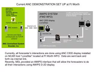
AutoNowCaster (ANC) on AWIPS • Running at FWD WFO • Running at MLB WFO • Collaboration with NWS/MDL Under NWS NextGen sponsorship • Provides • Gridded nowcast fields and boundaries on AWIPS • 60 min deterministic nowcasts of thunderstorm initiation, growth and decay • Updated every 5-6 min • Near real-time verification • Characteristics • Regional, automated heuristic system ingesting • observations and NWP output • Forecaster input and oversight Forecaster entered boundary Initiation Likelihood
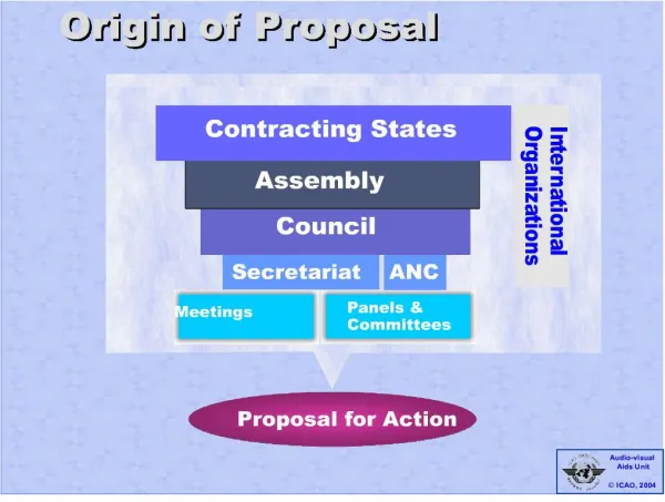
Combining Predictor Fields in AutoNowCaster Precip Accum Surface Analyses K-index Precipitable water VDRAS 4-D winds CAPE Bndry Lifting Cloud Top Temperature Change CIN Bndry & Storm Relative flow RHavg LI Frontal Lifting: Conv,Vorticity, θe VertSum : (CAPE, CIN, RH, θe) Max Vertical Velocity Satellite Clear Sky Bndry collisions Satellite Cumulus Clouds Radar Cumulus RucVertVel Ltg Climo StormInit Vertical Velocity Boundary Characteristics Stability Climatology Entrainment Proximity CI Boundary Small Scale Convergence Cumulus Growth Environment Module CI Observation module Trigger module Convective Initiation Nowcast
AutoNowCaster Products – Dallas/Ft. Worth WFO & Ft. Worth CWSU Extrapolation G&D nowcasts Initiation nowcasts Thunderstorm Initiation Nowcast Field Final Thunderstorm Nowcast Field: Initiation, Growth and Decay
AutoNowCaster Products on AWIPS – Melbourne WFO 60 min Thunderstorm Initiation Nowcast Field 60 min Final Forecast 60 min Growth/Decay 24 Feb 2010 19:20 UTC Initiation 24 Feb 2010 19:55 UTC -Shades of pink, red: New Initiation likely -Shades of blue, dark green, new initiation not likely Gray shades are 60 min thunderstorm initiation likelihood regions of 25, 30 and 32 dBZ ; color shades are > 35 dBZ
Activities and Enhancements during 2010 NWS MDL operational support of ANC and conversion to AWIPS-2 - Ken Sperow, Mamoudou Ba Validation of Forecaster-Over-The-Loop demonstration – Rita Roberts et al. Testing of SPC meso-analysis fields in ANC -Eric Nelson, Phillip Bothwell Comparison of ANC using RUC vs RR -Amanda Anderson Intensive 1 month demonstration of system @ FWD WFO in May - MDL meteorologists and Matt Volkmer (MLB forecaster) NOAA/GSD objective validation of ANC system -J. Mahoney et al NOAA/GSD subjective evaluation of forecaster use of ANC system– Woody Roberts Near real-time 60 min Verification Plot on AWIPS 2 km grid-to-grid comparison Radar reflectivity mosaic is used as the validation field
Activities and Enhancements during 2010 Tuning of ANC regimes for MLB WFO - Anderson, Matt Volkmer, Dave Sharp, Nelson, Roberts & others Exploration of automated tuning– NSSL (Lak) VDRAS high resolution fields for MLB – Jenny Sun, Ying Zhang Near real-time 60 min Verification Plot on AWIPS 2 km grid-to-grid comparison Radar reflectivity mosaic is used as the validation field 1654 UTC Thunderstorm Initiation Nowcast Field (MLB-WFO)
VDRAS: 4-D Variational Doppler Radar Analysis System (Sun and Crook) Assimilation of radar reflectivity and radial velocity data into a mesoscale cloud model to produce high resolution boundary layer winds and thermodynamic fields • High resolution (2-5 km) 3-D winds updated every 10 min • Horizontal temperature perturbation field (shaded) • Intensity of cold pools are well observed • High resolution detection of convergence zones • Real-time observations of vertical velocity (shaded) on the convective and mesoscale • Produces CAPE, CIN, RH and wind shear fields • RUC or WRF used as background
Role of the Forecaster at WFO • Enter convergence boundaries (Forecaster tools are on AWIPS) • Identify prevailing wind directions for the day • Use forecaster tools to adjust interest fields as needed to improve nowcasts product for end-user • Provide feedback on forecast performance of the system • Provide significant thresholds for different synoptic regimes • Provide input on important fields or thresholds that should be used to improve the system.
Regime: Ridge between Tampa and Miami This flow regime is characterized by low level southwest flow across much of East Central Florida. Lightning threat is maximized across much of East Central Florida in the afternoon and evening. 1615 UTC 1612 UTC Radar 1714 UTC Satellite 1600 UTC 1612 UTC Thunderstorm Initiation Nowcast Field Climatology Lightning Frequency
Regime: Ridge between Tampa and Miami This flow regime is characterized by low level southwest flow across much of East Central Florida. Lightning threat is maximized across much of East Central Florida in the afternoon and evening. 1655 UTC 1654 UTC Radar Satellite 1755 UTC 1700 UTC 1654 UTC Thunderstorm Initiation Nowcast Field Climatology Lightning Frequency
Operational Thunderstorm Nowcasting 1 Extrapolation Forecast (CSI) Skill 0.5 NWP .25 0 1 2 4 6 8 Forecast Length (hr)
Operational Thunderstorm Initiation Nowcasting 1 2 km resolution validation grid Extrapolation Forecaster-Over-the-Loop Validation Forecast (CSI) Skill 0.5 Initiation NWP - 2 km validation grid .25 0 1 2 4 6 8 Forecast Length (hr)
? Operational Thunderstorm Initiation Nowcasting 1 How to improve our CI nowcasting skill? Forecast (CSI) Skill 0.5 Initiation NWP .25 0 1 2 4 6 8 Forecast Length (hr)
Additional Operational Observations - X-Band, CASA Radars - High res. moisture fields (radar refractivity) - Denser network of surface stations - High resolution satellite obs (GOES-R) - GPS atmospheric profiles -Need to observe cold pools and intensity -Detect and monitor of temperature inversions ? 1 Forecast (CSI) Skill Forecast Systems need to include: -elevated convection - climatology, stability trends - incorporate weather regimes - blend of observations with NWP output (CoSPA) - probabilistic and ensemble nowcasts for aviation 0.5 .25 0 1 2 4 6 8 Forecast Length (hr)