Download
1 / 27
270 likes | 298 Vues
Scott C. Hagen, Ph.D., P.E. Peter Bacopoulos, Ph.D. Student Yuji Funakoshi, Ph.D. Candidate D. Michael Parrish, Ph.D. Qualified Mike Salisbury, Research Scientist David Coggin, Masters Student Satoshi Kojima, M.S.W.R. (Graduated SU05) Naeko Takahashi, ESL Student.

E N D
Scott C. Hagen, Ph.D., P.E. Peter Bacopoulos, Ph.D. Student Yuji Funakoshi, Ph.D. Candidate D. Michael Parrish, Ph.D. Qualified Mike Salisbury, Research Scientist David Coggin, Masters Student Satoshi Kojima, M.S.W.R. (Graduated SU05) Naeko Takahashi, ESL Student Real-Time Forecasting of Winds, Waves, Storm Surge & Tides
NOPP Real-Time Forecasting System Focus on the Waves St. Johns River Model: Hurricane Floyd Hindcast Modeling Outline
University of Miami: Hans C. Graber & Mark A. Donelan University of Central Florida: Scott C. Hagen University of Florida: Donald N. Slinn U.S. Army Corps of Engineers: Robert E. Jensen NOAA/AOML/HRD: Mark Powell & Peter G. Black NOAA NWS Meteorological Services Division: John L. Guiney Oceanweather, Inc.: Vincent J. Cardone & Andrew T. Cox Real-Time Forecasting System of Winds, Waves and Surge in Tropical Cyclones
IN-SITU Ships Buoys C-MANS AIRCRAFT Minobs GPS Dropsonde Vortex Messages NCEP AVN/ETA/GFDL Track Models Ensembles SATELLITE QUIKSCAT/ERS TOPEX/ERS TRMM and SAR NHC Warning Track and Intensity TC96 PBL/IOKA Basin Scale Winds Snapshots where Required HRD HWIND Wind Snapshot Inverse Modeling WINDGEN PROJECTION MODEL T-6T+120 Coupled Response Models NCEP Ensemble Results Probabilistic Results NHC Best Track Results NHC Track Suite Results Forecaster Decision Support Products and Aids
Wave Model: WAM-Cycle-4.5_2 • General Information • Action Balance Eqn. • Advection • Source Terms: • Sin , Sds , Snl , Sw-b , Sbrk • Modifications • Multiple Boundaries • Limiter independent • Depth Induced Breaking • Improved Architecture • Parallel Programming Paradigm
Operational Forecasting • Output: • Radiation Stress Fields to Surge Modeling • At 30-min intervals • Products • Map / Field Parameters • Verification • Ensembles
Operational Forecasting: ProductMaximum SWH over Forecast Cycle (August 25 to 30, 2005)
Operational Forecasting: Verification Verification Related to Watch Cycles
Operational Forecasting: Verification Verification Related to Watch Cycles
Probabilistic Output Products For Five Day Forecast Track Ensemble Output Locations near Landfall Duration of Hurricane Winds & Waves Spatial Extent of Hurricane Winds & Waves Wave Height Exceedance Map Utilization by Emergency Managers
Dr. Pedro Restrepo, NOAA/NWS/OHDMs. Reggina Cabrera, SERFC NOAA/NWS/OHD TIDES AND WAVES FOR THE NATIONAL WEATHER SERVICE RIVER FORECAST SYSTEM
Development of a 2D model for the St. Johns River to predict in real-time flow, tides (astronomic and meteorologic) Develop the model and examine test cases Examine uni-coupling model of short and long wave models Fully couple the short and long wave models NOAA/NWS/OHD Project Goals TIDES AND WAVES FOR THE NATIONAL WEATHER SERVICE RIVER FORECAST SYSTEM
Western North Atlantic Tidal (WNAT) Model Domain North America Central America Florida Continental shelf break Edge of Blake’s Escarpment Open-Ocean Boundary 60oW Meridian South America
Buffalo Bluff Jacksonville Wekela Lake George Mayport Florida Coast St. Johns River Region Flow
Code name = WNAT-SJR 75,436 nodes 138,622 elements Max node space = 160 km Min node space = 50 m 70oW 60oW 80oW North America 30oN 1 km Florida 110 km 160 km Cuba 20oN Central America 100 km 10oN South America
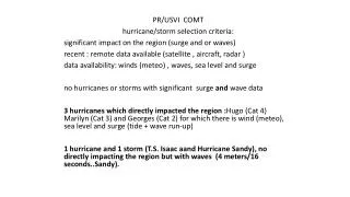
4 2 3 Code name = Pseudo-operational 26,543 nodes 47,763 elements Max node space = 40km Min node space = 50 m 450 m 200 m 1 80 m Wekela Mayport 170 m 110 m 50 m 400 m 80 m Jacksonville 100 m 50 m 50 m Florida Coast Lake George 200 m Buffalo Bluff 70 m 110 m 50 m
12 NOS Tidal Stations in St. Johns River Harmonic Analysis NOS : 37 tidal constituents Model: 23 tidal constituents 1 Mayport 8720625 RACY POINT, SJR , FL 8720220 MAYPORT , FL 2 Deviation from M.S.L. (m) Deviation from M.S.L. (m) Deviation from M.S.L. (m) 3 Buffalo Bluff Wekela 4 8720832 WELAKA, SJR , FL Days into Resynthesis Days into Resynthesis Days into Resynthesis Lake George
Hurricane Floyd (NOAA, 1999)
8720587 ST. AUGUSTINE BEACH, ATLANTIC OCEAN , FL 8720220 MAYPORT , FL 8720030 FERNANDINA BEACH, AMELIA RIVER , FL 8720832 WELAKA, FL 9/15/99 22:00 (H3) 9/15/99 20:00 (H3) Deviation from M.S.L. (m) Deviation from M.S.L. (m) Deviation from M.S.L. (m) Deviation from M.S.L. (m) 9/15/99 18:00 (H3) 9/15/99 16:00 (H3) 9/15/99 13:00 (H4) 9/15/99 10:00 (H4) 9/15/99 7:00 (H4)
Poster: Pseudo-Operational Forecast for the St. Johns River Scott C. Hagen, Ph.D., P.E. Civil & Environmental Engineering