Download
1 / 49
520 likes | 634 Vues
Delve into the necessity of a soil classification system and mapping for efficient inventory, management, and taxation. Learn about pedons, soil taxonomy, and the evolution from old to new classifications. Explore soil orders, families, and series in the modern soil taxonomy system. Understand the significance of drainage and moisture regimes in soil classification.

E N D
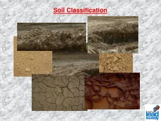
Why a classification system for soils? -mapping -taxation -inventory -management/use
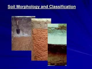
Pedon – basic unit of soil classification
Classification system must be: 1. based on quantifiable characteristics of soils 2. open-ended (we do not know about every soil…) 3. hierarchical (like biological systems) Also – use new names (avoid old meanings and baggage)
The “old” (1938) system of soil classification -based on interpretation and assumed genesis -grouped soils based on climate/vegetation assemblages
Three ORDERS in old system • Zonal or “normal” soils • -climate inputs dominate a soil’s genesis • -soil is in equilibrium with the climate/veg • Intrazonal soils • -salts, wetness or limestone bedrock • overwhelm the soil’s genesis 3. Azonal soils -too young, dry or sandy to have developed into Zonal soils
Zonal soils – examples Podzols – cool climates, coniferous forest Brunizems – tallgrass prairies Sierozems – desert soils Laterite soils – red tropical soils
Intrazonal soils – examples Rendzinas – shallow to limestone bedrock Gley soils – wet soils Peat soils
Azonal soils – examples Dry, sandy soils Shallow-to-bedrock soils Alluvial soils (young parent materials)
The new system of SOIL TAXONOMY -adopted in 1975, revisions ever since
Order – highest level (12) Suborder – (>60) Great Group – (about 300) Subgroup – (about 1600) Family – (>8000) Series – (>14,000)
The 12 soil orders • Gelisols – cold soils, permafrost (-el) • Histosols – organic soils, usually Very PD (-ist) • Spodosols – podzolization, cool, moist forested areas (-od) • Andisols – volcanic ash parent materials (-and) • Oxisols – old, weathered soils of the humid tropics, oxide clays (-ox) • Vertisols – shrink-swell clays, wet-dry climate, deep cracks (-ert) • Aridisols – desert soils, some evidence of B horizon formation (-id) • Ultisols – 1:1 clays dominate, red, weathered soils but not like Oxisols (-ult) • Mollisols – thick, dark A horizon, grassland soils (-oll) • Alfisols – minimally weathered soils, lessivage, not highly acidic (-alf) • Inceptisols – weak B horizon development, some pedogenesis (-ept) • Entisols – most weakly developed soils, no diagnostic B horizon (-ent)
Xeric Argiduridsubgroup Fine, smectitic, mesic Xeric Argidurids Family Aridisolorder Series: Reno Duridsuborder ArgiduridGreat Group
More about families Cation exchange class (sometimes) e.g., active, semiactive, superactive Sandy, mixed, frigid Typic Haplorthods Depth class (sometimes) Mineralogy Texture (Particle size family) Soil temperature regime (Table 7.13 in your book) Soil MOISTURE REGIME – can be determined from the taxonomic name (we’ve done this already)
The soil TEMPERATURE REGIME is all based on the MAST at 50 cm depth Four most common ones MAST Cryic <8C (but no permafrost)…like central Canada Frigid <8C (but warm in summer)…like da UP Mesic 8 – 15C……………………………like Ohio Thermic 15 – 22C………………………like Georgia Hyperthermic >22C…………………………….like Cuba
Cryic Frigid Mesic Thermic Hyperthemic
Frigid Mesic Mesic Mesic
“Iso-” minimal seasonal variation in soil temperature islands, and the tropics
It’s usually possible to estimate the drainage class of a soil, knowing only it’s taxonomic subgroup. Here’s how: Drainage class subgroup designation Well drained or drier ------- -------------- Moderately well drained Aquic ---------------- Somewhat poorly drained Aeric --------aqu----- Poorly drained ------- --------aqu----- Very poorly drained ------- -------------ist
Drainage class subgroup designation Well drained or drier ------- -------------- Moderately well drained Aquic ---------------- Somewhat poorly drained Aeric --------aqu----- Poorly drained ------- --------aqu----- Very poorly drained ------- -------------ist More practice… Fine-silty, siliceous, active, thermic Aeric Albaqualfs Loamy, mixed, active, mesic Aquic Arenic Hapludults Clayey, smectitic, shallow Typic Haplocryolls Coarse-loamy, mixed, active, mesic Aquic Fragiudepts Loamy-skeletal, mixed, superactive, thermic Cambidic Haplodurids Coarse-loamy, mixed, superactive, calcareous, mesic Aquic Torriorthents
More about subgroups… Three kinds: 1. Central concept – the “Typics” Typic Haplorthods Typic Dystrudepts Typic Eutrustox
More about subgroups… • Three kinds: • Central concept • Intergrades – trending toward another ORDER Alfic Haplorthods Spodic Dystrudepts Ultic Eutrustox
More about subgroups… • Three kinds: • Central concept • Intergrades • Extragrades – with some other important • or limiting attribute Lamellic Haplorthods Lithic Dystrudepts Aquic Eutrustox
Soil Taxonomy a quantitative system of soil classification, largely based on diagnostic horizons Diagnostic horizons at the surface – epipedons(all soils have one, and only one) Diagnostic subsurface horizons –soils may have none, one, or several
Epipedons – the major ones Mollic – mandatory for Mollisols Ca++ ions common, base saturation >50% value <3.5 moist, <5.5 dry chroma <3.5 moist OC > 0.6% Generally >25 cm thick moist for 3+ months at a time thru the year
Epipedons – the major ones Anthropic: resembles mollic, but can be dry high in phosphorous (due to long-term agriculture or human occupation)
Epipedons – the major ones Umbric: same as mollic, but base sat. <50% mountainous or hilly regions moist, acidic soils where OM decomposition is slowed due to high water table or cold temps
Epipedons – the major ones Histic – mandatory for Histosols water saturated for 30+ consecutive days (most years) organic materials dominate
Epipedons – the major ones Plaggen and Melanic – minor ones, we won’t discuss
Epipedons – the major ones Ochric: all others usually light colored, thin forested and dry soils
Diagnostic subsurface horizons -can be E or B horizons Entisols, by definition, lack a diagnostic B horizon
Diagnostic subsurface horizons Albic – E horizons (must meet thickness and color requirements)
Diagnostic subsurface horizons Argillic – clay-enriched Bt horizons - illuvial silicate clays (NOT formed in place) indicates a stable surface, because illuviation is slow, and therefore it must exceed rate of argillan destruction if argillans are to be present in sands, clay bridging is acceptable Required for Alfisols, Ultisols
Diagnostic subsurface horizons Glossic -degradation of an argillic (or kandic or natric) horizon -E/Bt or Bt/E -tongues of E material penetrating B material
Diagnostic subsurface horizons Natric: same as argillic, but has either: (1) prisms/columns in upper part, or (2) high Na content Bn or Btn
The poop on Na+ At low electrolyte concentrations, Na+ favors dispersion, just like other +1 cations (Na in upper profile can favor lessivage) At high electrolyte concentrations, as is typical of most desert and dryland soils, Na enhances flocculation. Btn becomes very clay-rich, and is virtually impermeable when wet. Biscuit tops Btn
Diagnostic subsurface horizons Kandic – like argillic, but low CEC clays dominate has lots of kaolinite and many oxide clays Kandiudult Bt Only in Ultisols
Illuvial clay ARGILLIC Oxide clays – Kandic Degraded - Glossic Na-rich - Natric
Diagnostic subsurface horizons Spodic - amorphous Al and humus, with or without Fe - sandy soils, little clay to inhibit podzolization - rapidly forming, under forest or heath veg. Required for Spodosols Bh, Bs, Bhs, Bsm, Bhsm
Diagnostic subsurface horizons Placic - thin pan, dark, cemented by Fe, Mn, and/or OC - 2-10 mm thick, brittle Has many similarities to Spodic horizon
Diagnostic subsurface horizons Oxic - mineral horizon in advanced stage of weathering - clay minerals are 1:1 or oxides - residual accumulation of Al, Ti, Fe and Mn - very old, stable surfaces - tropical/subtropical, wet/dry climates Required for Oxisols Bo
Diagnostic subsurface horizons Calcic - accumulation of secondary CaCO3 If cemented – Petrocalcic Ifplugged - Bkk Bk, Bkm
Diagnostic subsurface horizons Gypsic - rich in secondary gypsum/sulfates - sea spray and gypsic parent materials are sources - difficult to differentiate from Bk If cemented - petrogypsic By, Bym
Diagnostic subsurface horizons Salic - soluble salts (more soluble than gypsum) Bz
Diagnostic subsurface horizons Sulfuric - pH < 3.5, yellow (jarosite) mottles - toxic to plants - in tidal marshes
Diagnostic subsurface horizons Fragipan – Btx, Bx, Ex Duripan – silica cementation - Xeric soil moisture regimes - Bqm
Diagnostic subsurface horizons When all else fails…. Cambic weak "color" B horizon Bw horizon (some Bg horizons) must lack geologic structure or have soil structure not sandy (Bw forms too quickly in sands) Having a Cambic horizon kicks the soil OUT of Entisols and (usually) into Inceptisols Bw