TOO MUCH
Collaborative Science, Services and Tools to Support Integrated and Adaptive Water Resources Management Paul R. Houser Briefing for RLT June 21, 2011. TOO MUCH. Integrated Water Resources Science and Services (IWRSS). TOO LITTLE. Subcommittee on Water Availability and Quality

TOO MUCH
E N D
Presentation Transcript
Collaborative Science, Services and Tools to Support Integrated and Adaptive Water Resources Management Paul R. Houser Briefing for RLT June 21, 2011
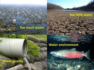
TOO MUCH Integrated Water Resources Science and Services (IWRSS) TOO LITTLE Subcommittee on Water Availability and Quality June 15, 2011 Thomas M. Graziano, Ph.D. Chief, Hydrologic Services Division National Weather Service National Oceanic and Atmospheric Administration POOR QUALITY
Outline TOO MUCH • Growing Water Challenges • Water Resources Stakeholder Needs • Recent Extreme Events • Federal Water Resources Consortium • Business Model • Strategy and Products • MOU and Team Charters • National Water Center TOO LITTLE POOR QUALITY
Growing Water Issues Growing need for water resources forecasts: Population growth and economic development are stressing water supplies and increasing vulnerability A changing climate is impacting water availability and quality Socio-economic risks of floods and droughts are escalating Decision-makers in water management sectors need: Expanded/new high resolution information in space and time Quantification of uncertainty to manage risk Enhanced communication of flood risk Blue Gold “The New Oil”
Stakeholder Needs Assessment Building Strong Collaborative Relationships for a Sustainable Water Resources Future Broadly recognized need for an integrative “Federal Tool Box” • Streamline access to Federal water resource capabilities • Share technology, data, information, models, best practices, policy, authorities Recommended the NOAA-lead Integrated Water Resources Science and Services (IWRSS) to prototype the Federal Tool Box 50 States + 12 Federal Agencies August 2010
Extreme Flooding Record Spring Flooding – Red River, Ohio River Valley, Mississippi River • Wettest snow pack in 60 years across much of the North Central United States • Extensive snowmelt flooding in Red River of the North, Upper Mississippi, James, Big Sioux and Minnesota Rivers • During late April-early May, Central US received 10-20+ inches of precipitation (600% of normal) • Major to Record Flooding occurred at several locations along the Ohio and from Cairo, Il southward • USACE employed several Mississippi floodways and flood control reservoirs to protect population centers • Evacuations in many states • U.S. Coast Guard, increased restrictions on river commerce • Missouri and Milk Rivers in flood and rising; USACE operating flood control reservoirs to mitigate impacts • CPC long-range precipitation outlook for upper mid-west and western U.S. above normal for June-August Observed Precipitation April 21, 2011 – May 5, 2011 Observed Precipitation April 21, 2011 – May 5, 2011
Extreme Flooding Tennessee - Kentucky FloodsApril 30 – May 4, 2010 Issue:NWS, USACE, and USGS were not able to share information and communicate in an effective manner during the peak of the event Action:Facilitate improved access to data and ensure common operating picture Issue:City officials and the public were not aware of devastating impacts until they occurred - severity and extent of inundation not communicated effectively Action:Implement comprehensive flood forecast inundation mapping system
Integrated Water Resources Science and Services (IWRSS) Aligns multiple agencies with complimentary water-related missions to: • Integrate services and service delivery • Improve river and flood forecasts • Provide new summit-to-sea water resources analyses and forecasts • Enable more effective use of resources Roadmap Document (February 2009) http://www.nohrsc.noaa.gov/~cline/IWRSS/IWRSS_ROADMAP_v1.0.pdf 8
Innovative Federal Consortium • New business model for interagency collaboration • Share technology, information, models, best practices • Started with three agencies, designed to expand • Members agree to work towards: • Interoperability of key systems and data synchronization • Standardized data formats • Enhanced geospatial information and visualization • Common Operating Picture • Coordinated R&D portfolio investments • Leverage multi-disciplinary skills to formulate effective solutions • Federal Tool Box – one stop shopping for federal water data and information • Joint governance structure – shared leadership model • Joint stakeholder outreach, educational efforts
New Digital Information Products Local Information (< 1 km2) High Resolution, Quantify Uncertainty Summit-to-Sea • Precipitation Snowfall • Snowpack • SoilMoisture • Evapotranspiration Snow Depth • Groundwater • RiverFlow • SurfaceStorage Water Content • WaterQuality Snow Temperature Watershed to National Information linked to Water Census Past Present Future Snowmelt
Memorandum of Understanding (MOU) Entitled “Collaborative Science, Services and Tools to Support Integrated and Adaptive Water Resources Management” Signing Ceremony: Wednesday May 11, 2011 at the Georgetown Waterfront Park, near the USGS Potomac River stream gage in Washington, D.C. Status and Current Activities • Signatories • Dr. Jane Lubchenco, NOAA Administrator • Dr. Marcia McNutt, Director of the U.S. Geological Survey • Rock Salt for the Honorable Jo-Ellen Darcy, assistant secretary of the Army for Civil Works
Memorandum of Understanding (MOU) Covers both IWRSS and the Federal Toolbox Signed May 11, 2011 NOAA NWS was lead author Charter One Team on System Interoperability & Data Synchronization USGS is lead author; In draft form Charter Two Team on National Flood Inundation Mapping Services USACE is the lead author; In draft form Charter Three Team to define/validate requirements and design common portal (“Federal Toolbox”) USGS is lead author Charter Four Governance USACE is lead author Status and Current Activities 12
Article II. Purpose The purpose of this Memorandum of Understanding (MOU) is to document the commitment of the Parties and formalize this interagency partnership to, better align agency programs within current authorities, enhance communications and the exchange and availability of information, and to establish opportunities for joint projects, programs, facilities, and other collaborative science, services and tools to support integrative and adaptive water resources management. This MOU is designed to facilitate the Parties' scientists, engineers, and managers to work together, achieve mutual goals and leverage resources for sharing information and planning, developing, and implementing science and services in support of integrative and adaptive water resources management. It is also intended to serve as the foundation and a mechanism for other Federal agencies and partners to join this collaborative partnership in the future to further address our Nation's water resources information and knowledge capacity needs. Memorandum of Understanding 13
Article IV. Responsibilities Develop and implement highly collaborative and integrative capabilities to protect lives and property, and support integrated and adaptive water resources management. The capabilities include: Interoperable systems, seamless data exchange and synchronization, and enhanced geospatial information and visualization to establish extensive situational awareness within a common operating picture. Enhanced water resource information and capabilities including: Historical and real-time data High resolution water resource forecasts and flood inundation maps Data and modeling applications and other software tools Contextual and background information about authorities, policies, and programs grounding science and engineering efforts of respective agencies, especially regarding water and related resources National water support center for transitioning science and technology advancements into operations and to generate a new seamless suite of water resources information and support. Participate in joint stakeholder outreach, educational efforts and evaluation activities. Identify areas of information gaps, redundancies, conflicts, and opportunities for subsequent joint project planning, program alignment, and problem solving. Memorandum of Understanding 14
Status and Plans for IWRSS National Water Center (NWC) 15
NWC Design & Construction Schedule 2010 2011 2012 2013 UA – Hydrology Program Design Scoping Meeting (June) Design Development Completed (May) Design Charrette – UA (July) Design-Build Contract Awarded (Funds Obligated for Construction) (September) Design concept vetted w/ Sen. Shelby’s Chief of Staff (July) Design concept vetted w/ NOAA DUS and CFO (August) Programmatic Design Completed (Dec) Groundbreaking (Winter) Construction Construction Completed (Fall) Design-Build Solicitation Released (June) Design-Build Kickoff Meeting (October) 16
Programmatic design completed Size ~ 58,000 s.f. with staff capacity of ~ 200 NWC Design Activities Functional Elements • Operations Center with Situation Rooms • Geo-Intelligence Laboratory • Collaborative Science and Software Engineering Studio • Information Technology Laboratory • Distance Learning Classroom/Auditorium • IWRSS Systems Proving Ground • Administrative Offices 17
National Water Center • Provide new high-resolution forecasts of water resource variables to help decision makers better manage water • Extend river and flood forecasting to provide maps showing forecasted spatial extent and depth of flooding • Integrate water resources information to provide one-stop shopping for stakeholders (Federal Toolbox) • Establish multi-agency proving ground to leverage capabilities and accelerate R2O • Establish Common Operating Picture Combine hydrologic forecasting operations and research to fill several critical gaps: Front Elevation (Looking Northwest From Hackberry) University of Alabama IOC Spring 2014 18
10 Integrated Water Resources Science and Services (IWRSS) themes have been identified for web portal, data products and services. NWC Operations Service Sectors 19
Pros: National Water Science Agencies: USGS, NOAA National Water Management Agencies: USACE, and BOR??? Enhancing interagency coordination on water science, services, and tools that will help Reclamation more effectively leverage interagency efforts and resources. Could save taxpayer $$ Increased direct advocacy for interagency tool and data development that address Reclamation needs Expedited access to Reclamation observations, tools and operations will benefit water information, forecasting, and decision making by other agencies. Cons: Reclamation already collaborates closely and effectively with a wide variety of water science, management, and stakeholder partners, including NOAA, USGS, and USACE. IWRSS and NWC proposed centralized operations. Should Reclamation sign IWRSS MOU?
Science Collaboration MOU Signing – Steps in the Process Timeline