Download
1 / 1
10 likes | 90 Vues
Explore neighbourhood interactions in urban growth simulation using a unified method to analyze impacts and validate simulations for Tokyo metropolitan area from 1984 to 1994.

E N D
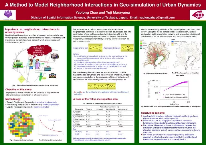
A Method to Model Neighborhood Interactions in Geo-simulation of Urban Dynamics Darling, how about we construct our house in this parcel? Impact index: great Modificatory Reilly’s Model Distance from developable cells: far Yaolong Zhao and Yuji Murayama Division of Spatial Information Science, University of Tsukuba, Japan. Email: yaolongzhao@gmail.com Importance of neighborhood interactions in urban dynamics We assume that in cellular environment all the cells in the neighborhood contribute to the conversion of developable cell. The contribution of one cell is associated with the state of it and the distance to the developable cell based on Tobler‘s First Law of Geography and modificatory Reilly‘s Gravity function in which no unit problem exists. We simulate urban growth of the Tokyo metropolitan area from 1984 to 1994 using this model constrained by land condition, land use zoning plan and transportation network, and assess the validation of the simulation via visual comparison and fractal dimension index. Neighborhood interactions are often addressed as the main factors deciding urban dynamics as other factors like natural constraints and institutional controls (land-use policies) which are comparatively stable in certain period. Impact of one cell: Aggregated impact: Where, fkh: constribution of one cell with land use k in the neighborhood to the conversion of the developable cell to land use h for next stage, Aj: area of the cell j, dji: the distance between the cell j and the developable cell i, Gkh: constant of the effect of land use k on the transition to land use h, Fkh: aggregated contribution of all the cells in the neighborhood, and m: number of the cells in the neighborhood. For one developable cell, there are just two statuses could be transformed to: conversion and no conversion. Therefore, in logistic regression, potential phof the conversion of the cell to land use h derived from the effect of neighborhood can be expressed as: Fig. 5 Visual comparison of simulation with reality Fig. 4 Simulated urban area in 1994 Fig. 1 Effect of neighborhood on location decision at micro-scale Objective of this study βohand βkh are the coefficients to be calibrated with maximum likelihood estimation. To propose a unified method for the analysis of neighborhood interactions in geo-simulation of urban dynamics Methodology A Case of the Tokyo metropolitan area • Tobler’s First Law of Geography: theoretical fundamentals • Modificatory Reilly’s Law of Retail Gravity: theory expression • Logistic Regression Approach: model constitution Tab. 1 Results of model Calibration ( from 1984 to 1994 ) Fig. 6 Area-radius plots of comparison between simulation and reality of built-up area Concluding remarks • Local spatial interactions between neighborhood land-use types play an important role in urban dynamics. • Tobler’s First Law of Geography is suitable as theoretical fundamental for understanding the neighborhood interactions. • The relative differences of the radial dimensions between the simulation and reality indicate that other factors influence the allocation decisions as well, such as policy considerations, tenure status etc. • The model proposed in this research provides a alternative approach to effectively explore and quantify the neighborhood interactions for geo-simulation of urban dynamics. PCP: percentage correctly predicted. ROC: relative operating characteristic. **: significant at p<0.05. Others significant at p<0.001. Fig. 2 An extended neighborhood Fig. 3 Scheme of impact gradient