Download
1 / 28
300 likes | 513 Vues
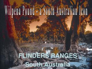
Wilpena Pound - a South Australian Icon. FLINDERS RANGES South Australia. St Mary Peak overlooking ABC Range. Stone survey cairn Rawnsley Bluff. St Mary Peak overlooking Wilpena Pound to the Elder Range. Rawnsley Bluff overlooking Chace Range. St Mary Peak overlooking Aroona Valley.

E N D
Wilpena Pound - a South Australian Icon FLINDERS RANGES South Australia
Renowned Australian artist, the late Sir Hans Heysen, described the Flinders Ranges as “the bones of nature laid bare”
Normally dry watercourses display the underlying bedrock – Bonney Sandstone / Rawnsley Bluff
Clem Corner Walking Trail on Rawnsley Park Station – one of the easier walks that is suitable for all ages
Rawnsley Bluff Trail – developed in 2000 with assistance from SATC & RGS. Crushed shale surface with <15° gradient
Rawnsley Bluff Trail – opposite view of previous slide looking back to the Elder Range
Rawnsley Bluff trail – climbing the foothills towards the pound quartzite escarpment / 500m climb
Rawnsley Bluff Trail – the escarpment is around the next bend
Lone Pine Lookout on Rawnsley Bluff Walking Trail, looking west to the Elder Range
Does South Australia have an Iconic Walking Experience? • Deep Creek? • Mt Lofty Ranges? • Mt Remarkable? • Gammon Ranges? • Wilpena Pound? • Heysen Trail? • Some Iconic Trails to learn from → →
The Milford Track is 54km of varied terrain – easy to tough in some of the wildest/wettest country in the worldThe track is designed as a 4 day trek with designated camping huts along the route.
Milford Track • Perhaps the best known walking trail in the world • Iconic track that is identified with the wild, wet wilderness of New Zealand South Island • 12000 walkers per year, limited by the NZ Department of Conservation • Mixture of Independent Trekkers and accommodated/ guided walking groups
Overland Track in Tasmania’s Cradle Mountain/Lake St Clair National Park
Overland Track • Six day walk through the central highlands of Tasmania • Iconic walking experience promoted as one of the great walks in Australia • 9000 visitors per annum – strictly controlled numbers in the summer walking season • Strong emphasis on conservation values when using the track • Managed by the Tasmanian Department of Tourism, Parks, Heritage & the Arts
The Larapinta TrailWestern McDonnell Ranges223km walking trail divided into 12 stages.
Larapinta Trail • Arid Zone environment • Water is a major factor for hikers • Trail sections have been designed to provide various levels of difficulty • Northern Territory Parks & Wildlife manage the trail • A discussion paper was released in June 2004 – available at www.nt.gov.au
Heysen Trail missing the mark? • Bypasses the town of Hawker • Bypasses Arkaba Station • Bypasses Rawnsley Park Station • Crosses the floor of Wilpena Pound • No useful camping huts in Flinders Ranges National Park • Ends at Parachilna Gorge (no services)
What could be done to make the Heysen Trail more user friendly? • Use the Larapinta model to develop ‘Stages” that are accessible from various points along the trail • “Stages” to be designed that will appeal to different levels of fitness & adventuring • Develop hiking huts at the end of each stage • Encourage tourism operators to develop accommodation packages that include a guided walking component
Who will manage the trail? • Iconic walking trails such as the Overland Track, Milford Track, Larapinta Trail are all managed by the State Environment Authority • Interesting to note that Tasmania has a State Department that includes Tourism & Environment • In South Australia the management of the Heysen Trail has recently been transferred from Rec. & Sport to DEH, however development of the trail outside of National Parks is not progressing
Key Targets/Objectives • Identify section/s of Heysen Trail that can be developed into an ‘Iconic’ walking trail • Obtain a commitment from the State Government to develop the trail • Target the Federal Government Australian Tourism Development Program for funding of the project • DEH to involve the SATC & local tourism association/operators in promoting the ‘walking experience’
Wilpena Pound - a South Australian Icon FLINDERS RANGES South Australia