Download
1 / 12
120 likes | 234 Vues
Explore various geological formations including moraines, faults, and outwash fans in the Hubbard and Russell Fiords, highlighting glacial retreat and possible tectonic activities.

E N D
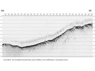
SW NE Line HUB15. Toe of Hubbard morainal bank, west of Gilbert. Lots of diffractions = hummocky terrain.
NW SE Line HUB13. Parallel to Hubbard ice face, along morainal bank, west of Gilbert.
W E Line HUB04. Through the gap. Note what appear to be occasional piles of soft sediments (arrows showing a few examples).
NW SE Line HUB08. East of Gilbert along Hubbard face and outwash fan below Variegated Glacier. The switch from glacier face (left) to outwash fan (right) is noted both by a bathymetric low in the middle of the line as well as a marked change in seafloor echo character from diffuse to sharp. We also have again small piles of soft sediment (some examples noted by arrows), although difficult to see at this scale.
NW SE Line RUS01. Asymmetric hump downslope from Hubbard. Possible push-moraine associated with Hubbard retreat? Dipping horizon to right looks very fault-like.
NW SE Line RUS01. Another small hump, mid-way in north-arm of Russell Fiord. Possible morainal bank left by Nunatak glacier when it protruded northward into Russell, just prior to its latest retreat.
SW NE Line RUS05. Cross-fjord profile showing possible tectonic deformation, mid-way in north-arm of Russell Fiord.
SW NE Line RUS12. Cross-fjord profile showing undeformed sediments in basin, at southern end of north-arm of Russell Fiord. But possible tectonic deformation on bench?
W E Line NUN01. Two features at entrance to Nunatak Fiord. At left is diffusely reflective mass, possible gravel, w/veneer of draped soft seds, likely post-most-recent-retreat of Nunatak glacier. Could be a terminal moraine, but morphology looks wrong. Maybe a lateral moraine from Hubbard? But, if so, how could it survive Nunatak when it flowed out and into Russell? At right is another feature with similar bathymetric morphology, but horizontally layered internal structure that goes deep, possibly penetrating sediments deposited prior to the most recent retreat of Nunatakglacier. This cannot be a morainal bank. Post-retreat sediments appear to be perched on top of feature: why? Why is there positive morphology here: fan sediments? Tectonic deformation? There does look to be a fault on west end of east feature, and maybe more faults of similar dip on west feature.
NW SE Line NUN01. Middle Nunatak Fiord. To right is the 1860 morainal bank – classic morphology also draped with post-retreat sediments. To left, with lots of diffractions, is the outwash fan from Orange Glacier et al. to the north. In the middle is a scarp that looks suspiciously like a fault.
NW SE Line NUN02. From 1860 morainal bank to E-Nunatak Glacier outwash fan. Layered, post-retreat sediments thicken toward the fan, and mud-waves at toe of fan evidence of downslope flows. Also probable debris flows at first change of gradient.
SW NE Line NUN05. Transect from what is presumably the scarp of the Fairweather fault (left) up toward outwash fan of the Nunatak-West Glacier, crossing in front of the outwash fan of the Nuntatak-East Glacier. Guessing that highly reflective, slightly depressed seafloor at base of scarp is rockfall. The three incisions center-right of plot are spectacular – and a complete mystery. What’s that pile in the middle of the rightmost incision?