Sea Ice Production and Heat/Salt Flux Data Set Release 2012-2013
50 likes | 154 Vues
Obtain boundary condition data for models with a comprehensive dataset on sea ice production, heat flux, and salt flux. Validate ice-ocean models using this valuable resource. Improve your research with high-resolution satellite truth data and ongoing project updates.

Sea Ice Production and Heat/Salt Flux Data Set Release 2012-2013
E N D
Presentation Transcript
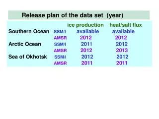
Release plan of the data set (year) ice production heat/salt flux Southern OceanSSM/I availableavailable AMSR 2012 2012 Arctic OceanSSM/I 2011 2012 AMSR 2012 2013 Sea of OkhotskSSM/I 2012 2012 AMSR 2011 2011
Creation of value-added sea-ice product from passive microwave (SSM/I, AMSR) Thin ice thickness algorithm of SSM/I and AMSR-E Calculation of heat flux from the estimated ice thickness Estimate of sea ice production assuming no oceanic heat Estimate of salt flux due to brine rejection by ice production Sea ice production dataset → Validation data for coupled ice-ocean models Southern Ocean Kusahara et al.(2010, Nature-comm.), Kusahara et al.(2010, JGR) Arctic Ocean Kawaguchi et al.(in press, JGR) Surface heat and salt flux dataset incorporating sea-ice growth and melt → Boundary condition data for various models Southern Ocean ACE CRC ice shelf-ocean coupled model: Galton-Fenzi(ph-D thesis) Non-hydrostatic ocean model: Nakayama, Ohshima et al. (preparation)
Syowa stn. Mapping of annual sea ice production from SSM/I (1992-2001)
Mapping of annual mean surface heat- and cumulative salt-flux (1992-2007) Salt flux Heat flux
Microwave radiometer PALSAR, ASAR Ice Profiling Sonar (IPS) ADCP (ice drift) Ongoing project for improvement Satellite truth observation coastal polynya + CT recorder (temp. salinity) Combined IPS &ADCP moorings ↓ Sea ice thickness & topography data with high temporal resolution ↓ Very good satellite truth data Chukchi Sea coastal polynya with UAF (Dr. Eicken) 2009 Jul. – 2010 Jul – continue Cape Darnley polynya (Antarctic) by JARE 2010 Feb.– 2011 Feb. (just recovered!)