Standardized Mapping Procedure for Forest Peatlands: Conservation and Renaturation Measures
This document outlines a standardized mapping procedure developed by the University of Applied Sciences Eberswalde and the State Environmental Agency of Brandenburg for assessing peatlands in forest areas. Recognizing the ecological significance of fens and transitional mires, this practical guide provides essential information for improved management and conservation. With an emphasis on reliable data collection and regular evaluations, the procedure supports decision-making for effective renaturation measures, ensuring these vital wetlands can thrive amidst environmental changes.

Standardized Mapping Procedure for Forest Peatlands: Conservation and Renaturation Measures
E N D
Presentation Transcript
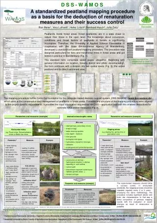
Horizontal mires e.g. Flood mires, Terrestrialisation mires or Water rise mires Sloping mires e.g. sloping fen, spring mire or percolation mire D S S - W A M O S A standardized peatland mapping procedure as a basis for the deduction of renaturation measures and their success control Peatlands inside forest areas (forest peatlands) are in a state closer to nature than those in the open land. The knowledge about occurrence, conditions and threat factors of peatlands in forests is significantly incomplete. Therefore, the University of Applied Science Eberswalde in cooperation with the State Environmental Agency of Brandenburg, developed a standardized peatland mapping procedure. The procedure was designed particularly for fens and transitional mires in forest areas and got tested in practice in Brandenburg (Fig. 1). The standard form comprises seven pages altogether. Beginning with general information on location, forestry district and photo documentation, the form continues with a division into two spatial levels (Fig. 2): the actual peatland and its direct catchment area. Fig. 2: Basic structure of the mapping form for mires in forest areas in Brandenburg Map Hydrogenetic mire type Soil type/threats and utilization Catchment area List of vegetation Drainage systems Fig. 1: Mapping sheets of „DSS-WAMOS Mapping of forest peatlands – Standard form“ The mapping procedure further forms the foundation for the computer-based decision support system „DSS-WAMOS“ (www.dss-wamos.de), which aims at the conservation and management of peatlands in forest areas. Contents and structure of the mapping procedure were aligned to the project-specific requirements. It provides the input information required for the DSS – application and with this enables deductions for concrete renaturation measures (Fig.3). drained minerotrophic mires Parameters and measures (example) Parameters and measures (example) Mire area • relief (primary, secondary, micro) • shape of lagg • water retaining system • mire depth / -bedrock • mire grounds • ecological mire types • hydrostatic (-dynamic) mire type • utilization • endangered and protected species catchment area • construction of ditches / hydrological situation in ditches regarding in- and outflow • nutrient path • downstream exposed nutrient-poor habitats (ponds, lakes ..) • mineral soil type Parameter and measures (example) The implemented measures should follow a success control. In renaturated peatlands, the mapping process should be repeated regularly every 2 or 3 years - employing the same methodology. The procedure includes significant abiotic and biotic site characteristics. In that way a direct comparison of previous mapping results with the evaluation of recent changes as result of renaturation is possible. 1 All Parameters available from DSS-WAMOS Mapping of forest peatlands – Standard form 2 Main ditches leads water from mire away; depth lower than mire thickness ( ≠ infiltration ditches: ditch depth bigger than mire thickness) 3As a result shrinkage, sinking and mineralization of the mire body Fig. 3: Selection of decision relevant parameters for moduel “hydraulic measures” in the DSS-WAMOS Mapping of forest peatlands – Standard form