Download
1 / 9
90 likes | 108 Vues
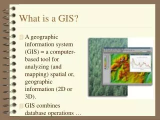
My.World.GIS is a learner-appropriate GIS tool designed for schools, with a focus on usability and technical administration. It addresses the challenges of implementing professional GIS tools in classrooms and offers a powerful yet easy-to-use platform for inquiry-based learning in geosciences, geography, and social sciences.

E N D
My World GIS: A Geographic Information System for Inquiry-Based Learning Daniel C. Edelson Geographic Data in Education (GEODE) Initiative Northwestern University
Motivation • GIS has been recognized for more than a decade as a powerful technology to support inquiry-based learning in • Geosciences • Geography • Social Sciences • As a result…very large investment in • disseminating professional GIS tools to schools • professional development for teachers • curriculum materials development • The result of that…very disappointing implementation rate in classrooms
What is missing? • Attention to the GIS tools themselves… • Professional tools were designed for professionals to be used in professional workplaces • Complexity • Users of GIS tools typically have hundreds of hours of training • Usability • Revenue for GIS developers is in features, not usability. • Technical administration • Difficult to install and maintain in school computing environments
Our solution… • A learner-appropriate and school compatible GIS tool • Power vs. complexity tradeoff • Identifying essential features for education • Usability • heuristic evaluation and user studies • Technical administration • Simple installation, administration, updating
Data Formats • Points • ESRI shapefile, tab or comma-delimited text files • Polygons and Polylines • ESRI shapefiles • GRIDS • Arcview GRID export, WorldWatcher, netCDF • Images • JPEG with world (TGW) files, geoTIFF
Data Organization • Data files • Local or remote (via local file system, URL, or THREDDS link) • Data library • List of layer names • Index files • Map from layer name to file location • My World automatically creates an index of its data library at launch.
THREDDS Integration • Can currently read grid data from data catalogues via THREDDS • To handle vector data will require data object definitions • Points • Polygons, polylines • To be driven by educational needs, goals, opportunities
My World GIS • My World team: • Principal Investigator: Daniel Edelson • Programmer: Eric Russell • Undergraduate research assistants: Greg Allen, Erin Orawski • Information and free trial download: http://myworld.worldwatcher.org • This work has been supported in part by the National Science Foundation under grants no. 9720687, and 0085946.