Major Winter Storm Forecast for Colorado: Snow Expected November 2, 2014
A winter storm is anticipated to affect Colorado starting Monday night, November 2, 2014, bringing significant snowfall and hazardous conditions. Snow will begin developing north of Fort Collins by midnight, spreading south into the Denver Metro area between 3 AM and 5 AM. Heavy snow is expected by 9 AM, with visibilities dropping to less than 1 mile. Total snow accumulation could range from 3 to 6 inches over the plains, with higher amounts in the foothills. Commuters should prepare for dangerous conditions and wind chill values below -10°F.

Major Winter Storm Forecast for Colorado: Snow Expected November 2, 2014
E N D
Presentation Transcript
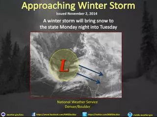
Approaching Winter Storm Issued November 2, 2014 A winter storm will bring snow to the state Monday night into Tuesday National Weather Service Denver/Boulder https://www.facebook.com/NWSBoulder https://twitter.com/NWSBoulder weather.gov/bou mobile.weather.gov
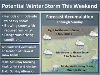
Winter Weather Briefing Key Points • Considerable uncertainty on storm track and strength. • Late tonight and Friday Morning: • Snow is expected to develop north of Fort Collins by midnight and then spread south into the Denver Metro area between 3am to 5am. • Northeast wind to 10 mph expected to increase 15 to 30 mph and gusty by 6am. • Snow is expected to become heavy by 9am with visibilities reduced to less than 1 mile. • 3 to 6 inches of snow expected over the plains by 9am. • Moderate to Heavy snow continues through afternoon before diminishing this evening. National Weather Service Denver/Boulder https://www.facebook.com/NWSBoulder https://twitter.com/NWSBoulder weather.gov/bou mobile.weather.gov
Winter Weather Briefing IMPACTS • Hazardous morning and evening commute. • Reduced visibilities to less than one half mile at times. • Dangerous wind chill values less than 10 below. • Total Snowfall amounts ranging 36 to 48 inches, with local amounts to 60 inches near the foothills. National Weather Service Denver/Boulder https://www.facebook.com/NWSBoulder https://twitter.com/NWSBoulder weather.gov/bou mobile.weather.gov
Winter Weather Briefing Timing/Snow Accumulation MountainValleys Plains Northern Mountains Foothills 8 to 14 inches 8 to 14 inches 8 to 14 inches 8 to 14 inches Monday Night - Tuesday Monday Night - Tuesday Tuesday Tuesday National Weather Service Denver/Boulder https://www.facebook.com/NWSBoulder https://twitter.com/NWSBoulder weather.gov/bou mobile.weather.gov
Approaching Winter Storm Issued November 2, 2014 National Weather Service Denver/Boulder https://www.facebook.com/NWSBoulder https://twitter.com/NWSBoulder weather.gov/bou mobile.weather.gov
Approaching Winter Storm Issued November 2, 2014 National Weather Service Denver/Boulder https://www.facebook.com/NWSBoulder https://twitter.com/NWSBoulder weather.gov/bou mobile.weather.gov
Winter Weather Briefing KEY POINTS RECAP • Hazardous morning and evening commute. • Reduced visibilities to less than one half mile at times. • Dangerous wind chill values less than 10 below. National Weather Service Denver/Boulder https://www.facebook.com/NWSBoulder https://twitter.com/NWSBoulder weather.gov/bou mobile.weather.gov

