Winds
E N D
Presentation Transcript
Winds • Winds are defined as the horizontal movement of air. • Winds are named by where they blow from.
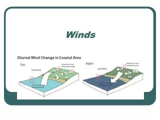
Local Winds • Different materials heat at different rates. (specific heat) • Along the shore the land surfaces will heat faster during the day. • The water surfaces will be cooler due to the slower heating.
Local Winds • This results in the air over land being warmed. • As it warms it expands and floats up creating an area of low pressure.
Local Winds • The area over water cools causing the air to contract. • This creates an area of high pressure.
Local Winds • The high pressure forces the air from the ocean to the low pressure on the land.
Local Winds • This is called an on shore or Sea Breeze
Winds • You will see that winds always blow from an area of High pressure to an area of Low pressure. • WINDS BLOW FROM HIGH TO LOW
Local Winds • At night the process is reversed. • The land cools quickly creating a high pressure over land. • The water retains its heat creating a low pressure over land.
Local Winds • This results in the high pressure over land pushing the air to the low pressure over the ocean. • This is called a land or off shore breeze.
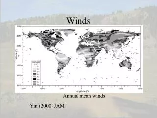
Global Winds • Heating of the planet is not uniform because of Earth’s shape. • The Earth receives more heat at the equator and less heat at the poles (angle of insolation) • This results in low pressure at the equator and high pressure at the poles
Global Winds • If winds blow from high pressure to low pressure you would expect the winds to blow in a straight line from the poles to the equator.
The winds do not blow in a straight line. • This is because of the rotation of the Earth. Also called the Coriolis Effect. • The rotation causes the winds to shift and the convection cells to break up into 3 cells in each hemisphere.
Global Winds • All of these factors combine to form our Global wind patterns.
Jet Streams • During WWII we discovered another set of wind belts found near the top of the troposphere. • These are located at the sub polar low and sub tropical high regions. • The winds blow from west to east at between 200 to 400 km/h.
Prevailing Westerlies • A majority of the United States lies within a wind belt called the prevailing westerlies. • This wind belt is responsible for moving “weather systems” from Southwest to Northeast across the United States.
Measuring Wind • To measure wind speed scientists use an anemometer. • To measure wind direction scientists use a wind vane.
Reading Isobars… • On a weather map you can determine the wind speed by looking at the isobars. • If the bars are close, the wind is fast (large gradient). • If the bars are spaced apart, the wind is slow (small gradient).
Calculating Gradient • Finding the gradient (how fast the wind is moving) is the same as finding the gradient of a mountain side (how steep the mountain is). • The formula is in the front page of the ESRT. • Change in Field Value/Distance