Download

1 / 7
70 likes | 181 Vues
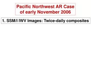
2006.08.20 . WV 6.2µ images with ARPEGE analysis on 1.5 PVU (Geop otential height , and wind > 50 kt) Patrick Santurette ( Meteo - France ). 2006.08.20 00 UTC ARPEGE Ana. Wind, height, 1.5 PVU. 2006.08.20 06 UTC ARPEGE Ana. Wind, height, 1.5 PVU. 2006.08.20 12 UTC

E N D
2006.08.20. WV 6.2µ images with ARPEGE analysis on 1.5 PVU (Geopotential height, and wind > 50 kt) Patrick Santurette (Meteo-France)
2006.08.20 00 UTC ARPEGE Ana. Wind, height, 1.5 PVU
2006.08.20 06 UTC ARPEGE Ana. Wind, height, 1.5 PVU
2006.08.20 12 UTC ARPEGE Ana. Wind, height, 1.5 PVU
From 00 UTC up to 12 UTC, we can see : • increasing of the jet, just ahead of the tropopause anomaly, and increasing of the diffluence • increasing of the humidity gradient (with humidity advection increasing from SW -Mediterranean Sea and Italy- related to the SW_jet) • the convective development occurs ahead of minimum of 1.5 PVU height 2006.08.20 12 UTC ARPEGE Ana. Wind, height, 1.5 PVU
The convective development occurs ahead of minimum of 1.5 PVU height • even if the tropopause anomaly decreases (in WV but also as seen by the model), this anomaly doesn’t act only as forcing the jet (i.e. as perturbation of the wind forcing ageostrophic motion), but has also a destabilizing action, because it is associated with cold air in mid and upper level (strong PV = vorticity AND cold air) 2006.08.20 18 UTC ARPEGE Ana. Wind, height, 1.5 PVU
The convective development occurs ahead and below the minimum of 1.5 PVU height, which is not very pronounced now on WV6.2 image, because at this stage it is no more very dynamic : weakening of the Z_1.5 PVU gradient and of the wind too ; but because of warm and moist air coming from the SW, and probably also accentuated by diurnal evolution, and because of coupling between these low-level conditions and upper-level anomaly, convection goes on; (also probably enhanced by local effects – orography) 2006.08.20 21 UTC 3 h ARPEGE forecast Wind, height, 1.5 PVU