G1000 SAR GRID TECHNIQUES
G1000 SAR GRID TECHNIQUES. G1000 Setup For Lat/Long Display. For Lat/Long in minutes.hundredths (W 77 52.50 instead of W 77 52’ 30”). To display lat/long lines and lat/long labels. Consider Aux Pg 3 to set degrees, minutes, hundredths. Select Menu, Map Setup, Land Group:

G1000 SAR GRID TECHNIQUES
E N D
Presentation Transcript
G1000 Setup For Lat/Long Display For Lat/Long in minutes.hundredths (W 77 52.50 instead of W 77 52’ 30”) To display lat/long lines and lat/long labels Consider Aux Pg 3 to set degrees, minutes, hundredths Select Menu, Map Setup, Land Group: - Text Med or Large (gives L/L text) - Range > than display (suggest 100) (displays Lat/Long lines)
Easy G1000 User Waypoint Setup • How To: • 1. Wpt /User page • 2. Depress cursor knob • and move to waypoint • 3. Hit Enter • 4. Give it a name With Lat/Long displayed, The cursor is fairly easy to Place on L/L coordinates to create user waypoints Recommend we use a naming standard of Grid #/letter and corner This leads to the question: once we start filling up waypoints, which ones can we erase? L/L of cursor displays for coordinate refinement
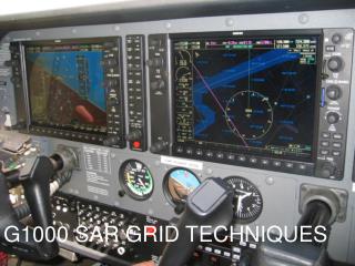
G1000 Inflight Use – Grid Search Option 1: PFD 10 mi scope (situational awareness), MFD 2 mi scope (accuracy) Select a PFD inset scale large enough to display enough of the search grid for situational awareness Select 2 mi range on the MFD—this displays L/L in ½ mile grids The grid lines can be hard to see with topo background selected . Recommend turning topo off and terrain on (for altitude alerting <1000’—note: the terrain grids are also ½ mile sections)
G1000 Inflight Use – Grid Search Option 2: PFD 5000’ scope (accuracy), MFD as required (situational awareness) 5000’ PFD inset scale gives a display of ½ mile lat/long grids. May need to turn topo off to read grids. Select MFD scale as desired for situational awareness