Download
1 / 9
90 likes | 229 Vues
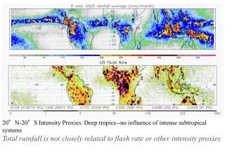
20°N-20°S Intensity Proxies: Deep tropics--no influence of intense subtropical systems Total rainfall is not closely related to flash rate or other intensity proxies. Proxies for Convective Intensity. • Lowest IR temperature - gives indication of cloud top height

E N D
20°N-20°S Intensity Proxies: Deep tropics--no influence of intense subtropical systems Total rainfall is not closely related to flash rate or other intensity proxies
Proxies for Convective Intensity • • Lowest IR temperature - gives indication of cloud top height • but poorly related to convective vertical velocity- • might even be only thin cirrus • • Highest altitude with >20 dBZ radar echo - good • • Highest altitude with >40 dBZ radar echo - good • • Lightning flash rate - good • • Lowest brightness temperature at 85 GHz or 37 GHz - good • How good? Which are best?
Intense convection using 4 quasi-independent proxies from 8 years of TRMM data (after Zipser et al. BAMS Aug 06)
Ocean convection less intense, but still responsible for more rain and deep clouds!
Courtesy Gerry Heymsfield Reminder from tropical storm Chantal that not all oceanic convection is weak. DC8 flew through this at 11 km and “iced up”.
Lesson Learned (EZ): Even weak oceanic convection can cause major problems, so if penetration is necessary to achieve scientific objectives, use an aircraft that can tolerate conditions. Courtesy Cheryl Yuhas
Seasonal distribution of intense convection, measured by 40 dBZ echoes exceeding 14 km and LIS flash rates > 127/minute (after Zipser et al. BAMS Aug 06) • Dominance of TX-OKLA, Argentina no surprise. Land dominance no surprise. Sahel storms in JJA no surprise. • Why does central Africa stand out compared with the Amazon and Indonesia? • What’s happening in the oceans east of South Africa? • Storms in southern Amazonia strongest in SON (burning season). Is this a coincidence? Significance for vertical transport? • Storms in Pakistan and Kashmir strongest in monsoon, near the Bay of Bengal and SE Asia in pre-monsoon. Current global models don’t know the difference between intense and ordinary convection. Better knowledge of dynamics, cloud and precipitation microphysics, lightning, radiative properties, and chemical transports of ALL classes of convective clouds is needed for credible models of our current atmosphere, let alone for the earth system in future climates. In situ data in convective clouds is a necessity to complement remote sensing data and model simulations.