Higher Resolution Operational Models
Higher Resolution Operational Models. Operational Mesoscale Model History. Early: LFM, NGM (history) Eta (mainly history) MM5: Still used by some, but phasing out NMM- Main NWS mesoscale model. Sometimes called WRF-NMM WRF-ARW: Heavily used by research and some operational communities.

Higher Resolution Operational Models
E N D
Presentation Transcript
Operational Mesoscale Model History • Early: LFM, NGM (history) • Eta (mainly history) • MM5: Still used by some, but phasing out • NMM- Main NWS mesoscale model. Sometimes called WRF-NMM • WRF-ARW: Heavily used by research and some operational communities. • The NWS calls their mesoscale run NAM: North American Mesoscale . Now NMM
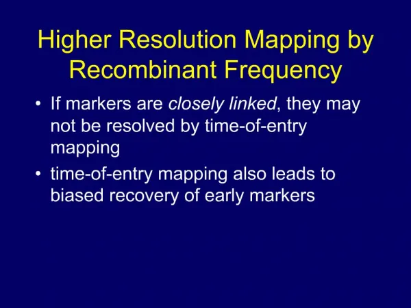
ground Ptop = 0 Eta Coordinate And Step Mountains = 1 MSL
Horizontal resolution of 12 km 12-km terrain
Drawbacks of the Eta Coordinate • The failure to generate downslope wind storms in regions of complex terrain • Weak boundary layer winds over elevated terrain when compared to observations • The displacement of precipitation maxima too far toward the bottom of steeply sloping terrain as opposed to the observed location near the top half of the terrain slope • The reduction in the number of vertical layers used to define the model atmosphere above elevated topography particularly within the boundary layer
Why WRF? • An attempt to create a national mesoscale prediction system to be used by both operational and research communities. • A new, state-of-the-art model that has good conservation characteristics (e.g., conservation of mass) and good numerics (so not too much numerical diffusion) • A model that could parallelize well on many processors and easy to modify. • Plug-compatible physics to foster improvements in model physics. • Designed for grid spacings of 1-10 km
WRF Software Infrastructure Dynamic Cores Mass Core NMM Core … Static Initialization Post Processors, Verification Obs Data, Analyses 3DVAR Data Assimilation Standard Physics Interface Physics Packages WRF Modeling System
Two WRF Cores • ARW (Advanced Research WRF) • developed at NCAR • Non-hydrostatic Numerical Model (NMM) Core developed at NCEP • Both work under the WRF IO Infrastructure NMM ARW
The NCAR ARW Core Model: (See: www.wrf-model.org) • Terrain following vertical coordinate • two-way nesting, any ratio • Conserves mass, entropy and scalars using up to 6th order spatial differencing equ for fluxes. Very good numerics, less implicit smoothing in numerics. • NCAR physics package (converted from MM5 and Eta), NOAH unified land-surface model, NCEP physics adapted too
The NCEP Nonhydrostatic Mesoscale Model: NMM (Janjic et al. 2001), NWS WRF • Hybrid sigmapressure vertical coord. • 3:1 nesting ratio • Conserves kinetic energy, enstrophy and momentum using 2nd order differencing equation • Modified Eta physics, Noah unified land-surface model, NCAR physics adapted too
The National Weather Service dropped Eta in 2006 as the NAM (North American Mesoscale) run and replaced it with WRF NMM. • The Air Force uses WRF ARW. • Most universities use WRF ARW
NWS NMM—The NAM RUN • Run every six hours over N. American and adjacent ocean • Run to 84 hours at 12-km grid spacing. • Uses the Grid-Point Statistical Interpolation (GSI) data assimilation system (3DVAR) • Start with GDAS (GFS analysis) as initial first guess at t-12 hour (the start of the analysis cycle) • Runs an intermittent data assimilation cycle every three hours until the initialization time.
October 2011 Update: NMMB • One-way nested forecasts computed concurrently with the 12-km NMM-B parent run for • CONUS (4 km to 60 hours) • Alaska (6 km to 60 hours) • Hawaii (3 km to 60 hours) • Puerto Rico (3 km to 60 hours) • For fire weather, moveable 1.33-km CONUS and 1.5-km Alaska nests are also run concurrently (to 36 hours). • A change in horizontal grid from Arakawa-E to Arakawa-B grid, which speeds up computations without degrading the forecast
Current NAM WRF-NMM (E-grid) 4/Day = 6 hr update Forecasts to 84 hours 12 km horizontal grid spacing New NAM NEMS based NMMB B-grid replaces E-grid Parent remains 12 km to 84 hr Four Fixed Nests Run to 60 hr 4 km CONUS nest 6 km Alaska nest 3 km HI & PR nests Single placeable 1.33km or 1.5 km FireWeather/IMET/DHS run to 36hr September 2011 NAM Upgrade
NMM • Was generally inferior to GFS