Higher Resolution Operational Models
Higher Resolution Operational Models. Operational Mesoscale Model History. Early: LFM, NGM (history) Eta (mainly history) MM5: Still used by some, but phasing out NMM- Main NWS mesoscale model WRF-ARW: Heavily used by research and some operational communities.


Higher Resolution Operational Models
E N D
Presentation Transcript
Operational Mesoscale Model History • Early: LFM, NGM (history) • Eta (mainly history) • MM5: Still used by some, but phasing out • NMM- Main NWS mesoscale model • WRF-ARW: Heavily used by research and some operational communities. • The NWS calls their mesoscale run NAM: North American Mesoscale . Now NMM
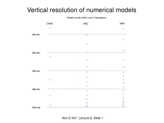
Vertical Coordinate Systems • Originally p and z • Then eta, sigma p and sigma z, theta • Increasingly use of hybrids– e.g., sigma-theta
ground ground Hybrid and Eta Coordinates Ptop Ptop = 0 Pressure domain = 0 Sigma domain = 1 MSL = 1
Horizontal resolution of 12 km 12-km terrain
Why Nesting? • Could run a model over the whole globe, but that would require large amounts of computational resource, particularly if done at high resolution. • Alternative is to only use high resolution where you need it…nesting is one approach. • In nesting, a small higher resolution domain is embedded with a larger, lower-resolution domain.
WRF Model Family A Tale of Two Dynamical Cores
Why WRF? • An attempt to create a national mesoscale prediction system to be used by both operational and research communities. • A new, state-of-the-art model that has good conservation characteristics (e.g., conservation of mass) and good numerics (so not too much numerical diffusion) • A model that could parallelize well on many processors and easy to modify. • Plug-compatible physics to foster improvements in model physics. • Designed for grid spacings of 1-10 km
WRF Software Infrastructure Dynamic Cores Mass Core NMM Core … Static Initialization Post Processors, Verification Obs Data, Analyses 3DVAR Data Assimilation Standard Physics Interface Physics Packages WRF Modeling System
Two WRF Cores • ARW (Advanced Research WRF) • developed at NCAR • Non-hydrostatic Numerical Model (NMM) Core developed at NCEP • Both work under the WRF IO Infrastructure NMM ARW
The NCAR ARW Core Model: (See: www.wrf-model.org) • Terrain following vertical coordinate • two-way nesting, any ratio • Conserves mass, entropy and scalars using up to 6th order spatial differencing equ for fluxes. Very good numerics, less implicit smoothing in numerics. • NCAR physics package (converted from MM5 and Eta), NOAH unified land-surface model, NCEP physics adapted too
The NCEP Nonhydrostatic Mesoscale Model: NMM (Janjic et al. 2001), NWS WRF • Hybrid sigmapressure vertical coord. • 3:1 nesting ratio • Conserves kinetic energy, enstrophy and momentum using 2nd order differencing equation • Modified Eta physics, Noah unified land-surface model, NCAR physics adapted too
The National Weather Service dropped Eta in 2006 as the NAM (North American Mesoscale) run and replaced it with WRF NMM. • The Air Force uses WRF ARW. • Most universities use WRF ARW
NWS NMM—The NAM RUN • Run every six hours over N. American and adjacent ocean • Run to 84 hours at 12-km grid spacing. • Uses the Grid-Point Statistical Interpolation (GSI) data assimilation system (3DVAR) • Start with GDAS (GFS analysis) as initial first guess at t-12 hour (the start of the analysis cycle) • Runs an intermittent data assimilation cycle every three hours until the initialization time.
March 2011 Upgrade of HiResWindow 4.0 km WRF-NMM 5.15 km WRF-ARW 48 hr fcsts from both Unless there are hurricanes 18Z Expanded PR/Hispaniola domain 00Z 12Z 00Z 12Z 00Z 12Z Guam 06Z 06Z 18Z
Details of NCEP HiResWindow Runs No Changes with This Upgrade
NMM • Was generally inferior to GFS