Kaneohe RIMPAC 2014 Pilot Brief
660 likes | 1.08k Vues
Kaneohe RIMPAC 2014 Pilot Brief. RIMPAC Hickam Pilots. Clendon Nakasone. July 1, 2014. HONOLULU CONTROL FACILITY. HCF is a Combined C ontrol Facility (CCF) HCF provides Center, Approach , Departure, and Tower ATC services in and around the Hawaiian Islands.

Kaneohe RIMPAC 2014 Pilot Brief
E N D
Presentation Transcript
Kaneohe RIMPAC 2014 Pilot Brief RIMPAC Hickam Pilots Clendon Nakasone July 1, 2014
HONOLULU CONTROL FACILITY • HCF is a Combined Control Facility (CCF) • HCF provides Center, Approach, Departure, and Tower ATC services in and around the Hawaiian Islands. • HCF domestic radar airspace extends approximately 250 NM around the Hawaiian Islands(Approximately 360,000 square miles).
HCF/RIMPAC AIRSPACE DIDI DIDI SUMMER DUKE CHART NOT TO SCALE
Flight Planning for NGF to RIMPAC Airspace • TO/FROM Warning Areas: File two flight plans • NGF to Warning Area • Warning Area to NGF • Ensure Flight plan times are updated as appropriate. • Filed routes: Use preferred routes contained in the chart on the next slide.
Preferred Routes NGF to/from HNL ROUTES (Non-Ordnance Routes)
NGF PREFERRED ORDNANCE ROUTES Including Sonobouys NOTE: Aircraft carrying ordnance may not enter HIGHWAY CENTRAL via KUCHI OR MILTI. (The route leading to the closest entry point to HWY CENTRAL is via JAZYY)
TO/FROM WORDN TO/FROM JAZYY TO/FROM BIGZO (HWY WEST) TO/FROM GARZZ (HWY EAST)
NGF ATC Operating Hours • NGF Tower open continuous: July 7-31, 2014 • NGF Approach operating hours: 0700 – 0000 Monday - Friday • NGF Approach airspace: • Normally 090 and below in Area A • May request up to FL240 in Area A to contain RIMPAC operations.
NGF ATC Operating Hours • HCF approach services provided by HCF Center, Sector 3 on 124.1/317.5 on weekends • This Center sector provides approach/departure services to MKK and enroute services to aircraft outbound/inbound to/from the US mainland • Not a controller dedicated to NGF APCH services only.
Helicopter Procedures for HNL and Ford Island Special procedures have been developed for RIMPAC VFR Hickam Helicopters. Please review the special procedures contained on the APAN website Special procedures have been developed for Ford Island HADR Helicopters. Please review the special procedures contained on the APAN website
NGF F-18 R3103 Operations Ordnance carrying F-18 aircraft will be operating between NGF and R3103 Temporary procedures, have been established and outlined in this PowerPoint presentation to expedite handling and provide standardization. These procedures were used during RIMPAC 2012 and the LAVA VIPER missions conducted in 2013.
NGF F-18 R3103 Operations On the flight to R3103, the aircraft may be carrying ordnance and will be on over water routes. Returning flights normally will not be carrying ordnance. Each flight may contain up to 2 F18s
NGF F-18 R3103 Operations R3103 missions will be scheduled as follows: July 15/16: 2130-0000 UTC, 0330-0800 UTC (no ordnance) July 20-27: 2000-2230 UTC, 0300-0730 UTC (ordnance flights) Aircraft Identification: will be NIKELXX NGF Approach will remain open until 0800Z daily NGF Tower will remain open 24 hours a day through
Flight planning for F-18 R3103 • NIKELXX will file two flight plans for each mission as follows: • NGF to R3103: NGF.NGF2.FUZZE..NIKKI.. LOKIE..SERAH..KOA at FL230 • R3103 to NGF: DARBB..SERAH..LOKIE..NUDSE..NGF at FL240. These routes will be used for the duration of RIMPAC (July 10, 2014 to July 30, 2014)
NGF KOA DARBB 19° 47’53”N 156° 23’56”W
NGF to R3103 NGF Approach will climb NIKELXX to 090 and hand off the aircraft to HCF Center Sector 3 (124.1/317.5) HCF Center may assume control of all NIKEL aircraft on the above route for climb and turns (from NGF Approach). NIKEL F18s are able to expedite their climb (when instructed by ATC), if necessary for traffic.
NGF to R3103 The flight can expect to be handed off to HCF Sector 4 (119.3/307.1), then HCF Center Sector 5 (126.0/278.3) KOA is the clearance limit. HCF Center Sector 5 will initiate a radar hand-off to Hula Dancer (127.0/266.4) prior to the PELE boundary.
R3103 to NGF Hula Dancer (127.0/266.4) will assign the OFDPS generated beacon code to NIKELXX and radar identify the aircraft Hula Dancer will instruct the aircraft to maintain VFR at FL245 and initiate a radar hand off to HCF Center sector 5 (126.0/278.3)
R3103 to NGF • Hula Dancer will forward the following information to HCF Center sector 5 at or prior to the radar handoff: • Number of aircraft in flight • Ordnance status
R3103 to NGF HCF Center will issue IFR clearance based on traffic in the area. When returning to NGF the flights will normally not be carrying ordnance and routing over the islands may be issued, if desired . Aircraft carrying ordnance must remain on an over water route.
R3103 to NGF HCF Center will issue descent clearance to 080 into the NGF area when traffic permits. NGF Approach will accept inbound aircraft at higher altitudes than specified in the LOA if necessary due to traffic. HCF Center will release control for descent to NGF approach as appropriate. Hung Ordnance: ATC will provide an overwater route, unless the pilot requests a direct route for safety reasons. HCF Center will advise NGF approach.
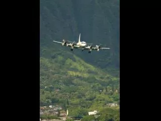
P-3 HANDSHAKE A single P-3 will be conducting “HANDSHAKE” operations involving imaging overhead Oahu from 7/9/2014 to 7/12/2014. These missions will normally be accomplished prior to landing at NGF after completing a mission in the south operating areas. The flight will have NO ordnance on board.
P-3 Handshake - FLIGHT PLANNING Pilots will file an IFR Flight plan containing the following components: Route of Flight: MILTI HNL MUGGE NGF Filed Altitude: 12,000’
P3 HANDSHAKE PROCEDURES FACSFAC will initiate a radar hand-off to HCF Approach (118.3/269.0) prior to MILTI The Pilot may request to hold in an area while the ground crews prepares for the handshake. HCF Approach will approve holding in an area which provides minimal impact on HCF traffic.
P3 HANDSHAKE PROCEDURES When ready to conduct the Handshake, the pilot will request to operate within a 7 NM Radius of HNL VORTAC HCF approach will approve the request based on traffic.
P3 HANDSHAKE PROCEDURES Restrictions to operating area may be applied by ATC due to avoid airspace conflictions and traffic. Altitude restrictions/changes may be assigned to minimize the impact on HCF traffic. The pilot will accept lower or higher altitudes if necessary for traffic. (NOTE: higher altitudes may result in the handshake being unsuccessful.)
P-3 HANDSHAKE PROCEDURES After the mission is complete, HCF Approach will descend the aircraft to 070 and initiate a radar hand-off to NGF Approach (125.0/263.5).
Honolulu International Airport Hot Spots Hot Spot 1 RWY 4R/4L thresholds are in close proximity. Due to location of tower, controllers are unable to determine if aircraft are lined up for RWY 4L or 4R
Honolulu International Airport Hot Spots Hot Spot 2 After landing on RWY 4R, if instructed to hold short of RWY 4L/8L, ensure that you hold short at the first hold bars.
Honolulu International Airport Hot Spots Hot Spot 3 Be aware that the turn from TWY E to TWY B is a quick turn immediately after RWY 4L. If aircraft misses the turn, hold short of RWY 8L and advise tower. Aircraft will reach RWY 8L quickly if they miss the turn on TWY B
Honolulu International Airport Hot Spots Hot Spot 4 TWY A, TWY V, TWY T, TWY RB, and TWY M all converge at or in close proximity to RWY 8L
Honolulu International Airport Hot Spots Hot Spot 5 Area not visible from Tower. Tower is not able to provide separation service between aircraft and vehicles.
Honolulu International Airport RWY 8L HOLD SHORT LINE
HNL CLASS BRAVO Procedures • All VFR aircraft are required to have a CLASS B clearance. • VFR aircraft must contact HNL clearance delivery prior to departure for Class BRAVO clearance • VFR arrivals must be familiar with CLASS B airspace and reporting points.
HNL CLASS BRAVO Procedures • VFR arrivals contact approach control for clearance into CLASS B. Remain clear of Bravo airspace until specifically cleared into or through BRAVO airspace.
EMERGENCIES • While in RIMPAC Airspace, advise the FACSFAC of emergency status as soon as possible • FACSFAC will forward information to HCF • If in HCF airspace, advise ATC as soon as possible • Provide the following initial information: • Nature of the emergency • Number of Persons On Board • Fuel in pounds remaining • Pilot’s intentions
EMERGENCIES • Provide the following additional Information when able: • Assistance requested • Notifications you would like ATC to make • Divert airport • Any other pertinent information • Barriers located at HNL, NGF, and BKH
EMERGENCIES • NGF Barriers: E-28 Bi-directional arresting gear RWY 4/22, 20 minute notification required. If the barrier had been engaged, it can be reset in less than 5 minutes. • HNL Barriers: 8R/26L and 4R/22L (BAK-12/14 bi-directional), 8L (textile barrier) • BKH barriers: E-28 Bi-directional arresting gear on both ends of RWYs 34/16
MINIMUM FUEL • “Minimum Fuel” Indicates that an aircraft’s fuel supply has reached a state where, upon reaching the destination, it can accept little or no delay. This is not an emergency situation but merely indicates an emergency situation is possible should any undue delay occur. • A minimum fuel advisory does not imply a need for traffic priority. • “Minimum fuel” declarations are essentially advisory in nature to ATC.
MINIMUM FUEL • If, at any time, the remaining usable fuel supply suggests the need for traffic priority to ensure a safe landing, the pilot should declare an emergencyand should re- port remaining fuel level (in minutes).
EMERGENCY FUEL • “The point at which, in the judgment of the pilot-in-command, it is necessary to proceed directly to the airport of intended landing due to low fuel. Declaration of a fuel emergency is an explicit statement that priority handling by ATC is both required and expected.”
HCF FREQUENCIES • HNL Tower: 118.1/257.8 • HNL Ground Control: 121.9/348.6 • HNL Clearance Delivery: 121.4/281.4 • HCF Approach/Departure (for HNL): 118.3/269.0 or 119.1/239.05 • HCF Departure (for HNL): 124.8/317.6 • HNL ATIS: 127.9/251.15
HCF FREQUENCIES • Other HCF Approach frequencies: • West of Kauai - 119.9/306.9 • West of Oahu - 126.5/269.4 • Northeast of Oahu – 124.1/317.5 • Southeast of Oahu – 119.3/307.1 • Vicinity of Big Island – 126.0/278.3 • North of Maui (beyond 25 NM) – 127.6/291.6 • East of Maui (beyond 25 NM) – 126.6/284.6 • North of Maui (within 25 NM) – 120.2/322.4 • South of Maui (within 25 NM) – 119.5/225.4
SATELLITE TOWER FREQUENCIES • OGG Tower – 118.7/279.6 • KOA Tower – 120.3/254.3 • BSF Tower – 126.3/236.6 • BKH Tower – 126.2/360.2 • ITO APCH – 119.7/269.2 • MKK Tower – 125.7/306.2 • NGF Tower – 120.7/360.2