LYU0401 Location-Based Multimedia Mobile Service
610 likes | 725 Vues
This paper explores various algorithms and techniques for localization to develop a robust location-based multimedia service system. It focuses on the process of area-based probability and center of mass methodologies, outlining steps for data collection and signal measurement in designated areas. The study emphasizes accuracy through the application of Bayes' rule and Gaussian distribution for location estimation. Results indicate high precision in localization, with significant potential for practical applications such as multimedia guidance systems. Development tools and environment specifics are also discussed.

LYU0401 Location-Based Multimedia Mobile Service
E N D
Presentation Transcript
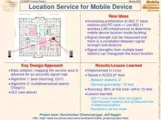
LYU0401 Location-Based Multimedia Mobile Service Clarence Fung Tilen Ma Supervisor: Professor Michael Lyu Marker: Professor Alan Liew
Outline • Objective • Introduction to Localization • Area-based Probability • Center of Mass • Multimedia Guidance System • Conclusion
Objective • To study different algorithms and techniques in localization • To find out a suitable localization method for Location-Based Service • To develop an application for rapid Location-Based Multimedia Service System Development
Main Steps in Localization Decide the Areas Measure Signals at Decided Areas Create a Training Set Create a Testing Set Measure Signals at Current Position Apply Suitable Algorithm Return the most likely Area
Collecting Training Set Data (I) • In one particular area Ai, we read a series of signal strengths (sijk ) for a particular APj with a constant time between samples • We estimate sij by averaging the series, {sij1, sij2…, sijo }
Collecting Training Set Data (II) • We read signals of all n APs, so we have the fingerprints at Ai • We read signals at all m areas
Collecting Testing Set Data • collects a set of received signal strengths when it is at certain location • similar to the fingerprints in the training set • a set of average signal strengths from APs
Data Processing • delete some access points that have least contribution to localization • To shorten computation time • input -92 dBm for missing signal strengths
Area-Based Probability (ABP) Advantages: • Area-based approach • More mathematical approach • Higher accuracy Approach: • compute the likelihood of the testing set (St) that matches the fingerprint for each area (Si)
Assumptions in ABP • Signal received from different APs are independent • For each AP, the sequence of RSS sijk, is modeled as a Gaussian distribution
Applying Bayes’ rule • We compute the probability of being at different areas Ai, on given the testing set St • P(Ai |St) = P(St |Ai)* P(Ai)/ P(St) (1) • P(St) is a constant • Assume the object is equally likely to be at any location. P(Ai) is a constant • P(Ai |St) = c*P(St |Ai) (2)
Gaussian Distribution • We compute P(St |Ai) for every area Ai ,i=1…m, using the Gaussian assumption • Integral of Normal Function taking the interval as 1
Error function erf(x) • Express Integral of Normal Function in terms of erf • Approximate value of erf by a series
Use of probability • Discrete Space Estimation • Only fixed number of locations in the training set can be returned • Eg. Return the area Ai with top probability • Continuous Space Estimation • Continuous range of locations can be returned • Return locations may or may not be in the training set • Eg. Finding Center of Mass
Accuracy of Discrete Space Estimation • Default sample size of testing set = 4 • 80 testing sets for each of the 12 locations
Continuous Space Estimation (CSE) • Advantage: • Return locations may or may not be in the training set • Higher accuracy • Suitable for mobile application • Two techniques: • Center of Mass • Time-Averaging
Center of Mass • Assume n locations • Treat each location in the training set as an object • Each object has a weight equals to its probability density • Obtain Center of Mass of n objects using their weighted positions
Center of Mass • Let p(i) be the probability of a location xi, i=1,2 …n • Let Y be the set of locations in 2D space and Y(i) is the corresponding position of xi • The Center of Mass is given by:
Experiment on Center of Mass • 16 positions for the training set • In every location, we use our system to perform positioning for 100 times • Totally we get 1600 records
Analysis of Experiment Result • If the tolerance of error is 2 meters and 3 meters, the accuracy of our system is 85% and 94% respectively • A few estimated points with a large distance error (3m to 5m) • Inaccuracy in testing set • Frustration in signal strength
Application System • In our project, we have implemented two development tools • Wi-Fi Location System (WLS) • To develop Location-Based System • Multimedia Guidance System (MGS) • To develop Location-Based System with multimedia services • Developer can develop any Location-Based Multimedia System using our tools
Development Environment • Platform: • Window CE • Window XP, 2000 • Technology: • IEEE 802.11b • Tools • Embedded Visual C++ 4.0 • Visual Studio .NET 2003
Wireless LAN Terminology • Media Access Control address (MAC Address) • 48 bits long • unique hardware address • e.g. 00:50:FC:2A:A9:C9 • Service set identifier (SSID) • 32 character • Wireless LAN identifier • Receive Signal Strength Indicator (RSSI) • signal strength • unit is in dBm
Wi-Fi Location System (WLS) • Development Tool for Location-Based System • Simplify development steps • Increase the efficiency and productivity • It divides into 3 components • Wi-Fi Signal Scanner (WSS) • Wi-Fi Data Processor (WDP) • Wi-Fi Location Detector (WLD)
Wi-Fi Location System • Wi-Fi Signal Scanner • To collect the signal strength received from access points • Wi-Fi Data Processor • To process collected data • To filter noise data • Wi-Fi Location Detector • To detect the location in target place • To show the detected position name and corresponding position at Map Picture
Multimedia Guidance System (MGS) • WLS Limitations • only provides Location-Based services • does not support any multimedia services • Discrete Space Estimations • We create new development tools to support multimedia services
Multimedia Guidance System (MGS) • Multimedia Guidance System is a development tool to support multimedia service • It consists of three components • Wi-Fi Signal Scanner (WSS) • Multimedia Guidance Processor (MGP) • Location-Based Multimedia Service System (LBMSS)
Multimedia Guidance System • Deploying Procedure Collecting Signal strength data Processing Data and generating LBSData Deploying System with clients and server application
Wi-Fi Signal Scanner (WSS) • To collect the signal strength received from access points • The collected data received from WSS is then processed by MGP • Same as WSS in WLS
Wi-Fi Signal Scanner Number of received data MAC Address SSID WEP Signal Strength Total Number of Signal Strength Mean of Signal Strength
Multimedia Guidance Processor (MGP) • To process and filter collected signal strength data • To set client environment in LBMSS • Server Address • Availability of Service • Position Information • Video • Picture • Position in Map Picture
Multimedia Guidance Processor • Data Processing Procedure Open the MGP Set the project name, server path and map picture path in setting Setting Lines Set the name, data, video, picture, position in the map picture and point of interest Add/Delete the target Position Filter the noise data Select service for mobile client Generate location-based data
Multimedia Guidance Processor Position Information Access Point Information Position Setting Service Setting Information Section Environment and Options Setting
Location-Based Multimedia Service System (LBMSS) • To provide multimedia service for users • It mainly consists of two parts • Client • Server • Chat and Management Server • Paint Server • Media Server
Overall Architecture • Techniques on Client/Server model in LBMSS • Socket Programming in .NET • Multithread Model (AsyncCallback, Non-Blocking Function) • Encode object variable into byte stream • Import Native Code (Visual C++ API) to Managed Code (.NET API) • Control other program by CreateProcess() API
Paint Server • To provide paint service • It has two main functions • Store Client’s Artwork • Print Artwork for Client
Chat and Management Server • To provide chat service • It shows the current position of all clients on the map
Media Server • To provide media service • It is made by existing server architecture (e.g. HTTP, FTP, Streaming Server)
Client • To provide multimedia service for users • Client program mainly has 4 services • Guide • Paint • Chat • Video
Client • Guide Service • Select Destination • Guide Line shows on Map Tab • Implement by Shortest Path Algorithm
Shortest Path in the Guide Service • We define the nodes as the turning points or the ending of the corridors