Download
1 / 15
150 likes | 175 Vues
This study explores the development of a future geometric and geopotential datum for physical heights using GNSS-derived coordinates and a geophysical model. It aims to improve accuracy, consistency, and ties for engineering and scientific applications. The implementation includes adjusting bench marks and applying velocities to revert back to the datum epoch.

E N D
Physical Heights from GNSS-Derived Geometric Coordinates and a Geophysical Model (8174) Dr. D.R. Roman and Dr. X. Li
What will a future geometric frame look like? • With only 15 minutes of GNSS data to have cm-level accuracy • A more geocentric frame – consistent with others (ITRF/WSG84) • Will likely retain CORS (i.e., not PPP) • Better velocities for all stations (Reprocessing) • Agreeable datum for regional use (U.S., Canada, Mexico, etc.) • More consistent tie for engineering and scientific applications • Realized using Online Positioning User Service (OPUS) suite • Passive bench marks serve as secondary access and for backup
Implementation • Foundation CORS tied to IGS solutions • Reprocessing yields consistent CORS coordinates • Bench Marks are then adjusted to fit CORS control • GNSS/OPUS coordinates supersede bench mark values • Velocities applied to revert back to datum epoch (2022.0) • Effectively provides “fixed” plate & state plane coordinates • Permits use for RTK positioning at current epoch
What will a future geopotential frame look like? • Scientific basis that can be modeled & updated • geoid change, MSL rise, local effects • More consistency in heights across the region • Better ties between geoid (MSL), TBM’s (LMSL) & MODT • Geoid (MSL) = LMSL - MODT • Better basis for comparisons with SIRGAS
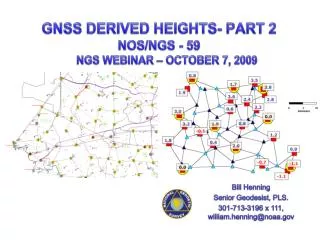
Geoid Slope Validation Studies 2014 and 2017 • Survey Techniques • BM’s installed ~1.5km • Leveling (double run) • Abs./Rel. Gravity • Vertical Gravity Gradient • Long-session GPS • Deflection of Vertical • GSVS 11 – sub-cm • GSVS 14 – prel. 2 cm • GSVS17 – in planning
International Great Lakes Datum (IGLD) Replacement • Current model (IGLD 85) based on NAVD 88 geopotential • Update should be based on common geopotential model • Each Lake would have it’s own geopotential surface • Likely some effects from currents, etc. (water topography) • Ideal solution is a geopotential model at one arcminute • Acceptable solution is a geoid height model combined with a gravity model at same resolution • Current geopotential models only 5’s => omission errors
Collocated CORS and WLS Stations • Great Lakes WLS in IGLD 85 • U.S. side has 53 active stations • CO-OPS visits annually to survey • NGS GPS campaign 5 yr. cycle • Looking to use OP vice BB • Great Lakes CORS stations • Master WLS on each Lake • Lake Erie: Buffalo, Cleveland, Marblehead • Superior: Point Iroquois, Marquette, Grand Marais • NGS surveys fix TBM positions to sub-cm relative accuracy • CO-OPS survey makes mm-level ties between TBM & WLS
Summary • Existing datums are treated separately • They both have meter-level defects • Future datum will be combine geometric and geopotential • Consistent with global models but regional in nature • GNSS-derived positions from OPUS at cm-level • Coordinates used in geopotential/geoid model for heights • Orthometric heights for terrestrial and dynamic for Lakes • Close ties between physical heights and ocean surface • Regional usage of datum by multiple countries
Questions? Daniel R. Roman, Ph.D. dan.roman@noaa.gov +1-301-713-3200 x103