Download
1 / 76
760 likes | 781 Vues
Join us at the Lindy C. Boggs International Conference Center in New Orleans, Louisiana, on June 20-21, 2011, for a comprehensive seminar led by David B. Zilkoski. Learn about establishing GPS-derived ellipsoid and orthometric heights and best practices in geospatial solutions. Topics include types of heights, NGS guidelines, and achieving centimeter-level accuracy in GPS measurements. Explore the importance of the New National Vertical Datum and understand error sources in surveys. Enhance your knowledge of geospatial solutions through collaboration and innovation.

E N D
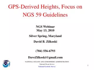
Integrated and Collaborative Organizations Create Geospatial Solutions Guidelines for Establishing GPS-Derived Ellipsoid and Orthometric Heights Static GPS/RTN Best Practices Seminar Lindy C. Boggs International Conference Center New Orleans, Louisiana June 20-21, 2011 David B. Zilkoski Geospatial Solutions by DBZ DaveZilkoski@gmail.com (704) 668-6793 Geospatial Solutions by DBZ
Integrated and Collaborative Organizations Create Geospatial Solutions Acknowledgements Borrowed slides from several presentations by the following NGS employees: And Myself (when I was employed by NGS) Edward Carlson Curtis Smith Dan Roman Dru Smith Joe Evjen Kevin Choi Geospatial Solutions by DBZ
Integrated and Collaborative Organizations Create Geospatial Solutions Topics To Be Discussed • Review of types of heights and their accuracies • How NGS guidelines can help to reduce, detect, and/or eliminate error sources • Summary of NGS 58-Guidelines for Establishing GPS-Derived Ellipsoid Heights • A step-by-step description of NGS 59-Guidelines for Establishing GPS-Derived Orthometric Heights • Brief discussion of Why the New National Vertical Datum is Necessary Geospatial Solutions by DBZ
To understand how to achieve GPS-derived orthometric heights at centimeter-level accuracy, three questions must be answered Integrated and Collaborative Organizations Create Geospatial Solutions 1) What types of heights are involved? 2) How are these heights defined and related? 3) How accurately can these heights be determined? Geospatial Solutions by DBZ
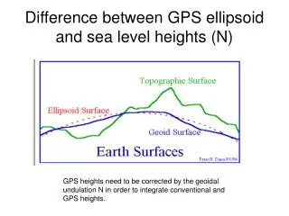
Ellipsoid (GPS) Orthometric (Leveling) Geoid (Gravity & Modeling) Types of Heights Involved
Ellipsoid, Geoid, and Orthometric Heights “h = H + N” Earth’s Surface P Plumb Line Ellipsoid h Q N Mean Sea “Geoid” Level PO h (Ellipsoid Height) = Distance along ellipsoid normal (Q to P) Ocean N (Geoid Height) = Distance along ellipsoid normal (Q to PO) H (Orthometric Height) = Distance along plumb line (PO to P)
Expected Accuracies • GPS-Derived Ellipsoid Heights • Better than 2 centimeters • Geoid Heights (GEOID09) • Relative differences should typically be less a few mm in 10 km • Total misfit is 1.4 cm squared • Leveling-Derived Heights • Less than 1 cm in 10 km for third-order leveling
Integrated and Collaborative Organizations Create Geospatial Solutions Topics To Be Discussed • Review of types of heights and their accuracies • How NGS guidelines can help to reduce, detect, and/or eliminate error sources • Summary of NGS 58-Guidelines for Establishing GPS-Derived Ellipsoid Heights • A step-by-step description of NGS 59-Guidelines for Establishing GPS-Derived Orthometric Heights • Brief discussion of Why the New National Vertical Datum is Necessary Geospatial Solutions by DBZ
Integrated and Collaborative Organizations Create Geospatial Solutions ExecutionofSurveys;SourcesofError • Errors may be characterized as random, systematic, or blunders • Randomerror represents the effect of unpredictable variations in the instruments, the environment, and the observing procedures employed • Systematicerror represents the effect of consistent inaccuracies in the instruments or in the observing procedures • Blunders or mistakes are typically caused by carelessness and are detected by systematic checking of all work through observational procedures and methodology designed to allow their detection and elimination Geospatial Solutions by DBZ
Integrated and Collaborative Organizations Create Geospatial Solutions GUIDELINES • Guidelines Help to Detect, Reduce, and/or Eliminate Error Sources • Special Projects Are Performed to Develop Guidelines • Guidelines Are Modified as Procedures, Equipment, and Models Improve Geospatial Solutions by DBZ
24 - Hour Solutions Day 300 -5.15 Day 301 -5.95 Day 302 -5.70 Day 303 -5.97 Day 304 -5.80 5-Day Ave (-5.71) = 0.5 Day 302 Mean = -3.1 Day 300 Day 304 Mean = -7.5 Day 301 Day 303 Mean = -5.5 = 0.3 = 4.4
Day 130 Mean (1.33 cm) / Std. Dev. (0.83 cm) Mean = 1.0 = 1.3 Day 131 Mean (1.01 cm) / Std. Dev. (0.47 cm) 1.3 0.6
Day 130 Mean (1.33 cm) / Std. Dev. (1.15 cm) Mean = 1.3 = 2.1 Day 131 Mean (1.03 cm) / Std. Dev. (0.58 cm) 2.0 0.5
Day 130 Mean (1.02 cm) / Std. Dev. (1.54 cm) Mean = 1.0 Day 131 Mean (1.05 cm) / Std. Dev. (0.96 cm) = 2.4 2.0 0.3
Two Days/Different Times -9.184 > -9.185 -9.185 Difference = 0.1 cm “Truth” = -9.218 Difference = 3.3 cm Need a Network! Line is greater than 10 km
Recommendations to GuidelinesBased on Special Studies • Must repeat base lines on different days and at different times of the day • Must reobserve repeat base lines that disagree by more than 2 cm • Must FIX integers • Stations Must Be Connected to at Least its Two Nearest Neighbors
Integrated and Collaborative Organizations Create Geospatial Solutions Topics To Be Discussed • Review of types of heights and their accuracies • How NGS guidelines can help to reduce, detect, and/or eliminate error sources • Summary of NGS 58-Guidelines for Establishing GPS-Derived Ellipsoid Heights • A step-by-step description of NGS 59-Guidelines for Establishing GPS-Derived Orthometric Heights • Brief discussion of Why the New National Vertical Datum is Necessary Geospatial Solutions by DBZ
Guidelines for Establishing GPS-Derived Ellipsoid Heights (Standards: 2 cm and 5 cm) Available “On-Line” at the NGS Web Site: www.ngs.noaa.gov
Integrated and Collaborative Organizations Create Geospatial Solutions GPS Ellipsoid Height Hierarchy CORS/FBN/Control Stations (75 km or greater) Primary Base (40 km) Secondary Base (15 km) Local Network Stations (7 to 10 km) Geospatial Solutions by DBZ
Primary Base Stations • Basic Requirements: • 5 Hour Sessions / 3 Days • Spacing between PBS cannot exceed 40 km • Each PBS must be connected to at least its nearest PBS neighbor and nearest control station
Secondary Base Stations • Basic Requirements: • 30 Minute Sessions / 2 Days /Different times of day • Used to Bridge Gap Between Primary and Local Control Stations • Spacing between SBS cannot exceed 15 km (may need to be reobserved more often due to length) • All base stations (primary and secondary) must be connected to at least its 2 nearest primary or secondary base station neighbors
Local Network Stations • Basic Requirements: • 30 Minute Sessions / 2 Days / Different times of the day • Spacing between LNS (or between base stations and local network stations) cannot exceed 10 km • All LNS must be connected to at least its two nearest neighbors
Local Network Stations • Basic Requirement30 Minute Sessions / 2 Days / Different times of the day • NOTE: In order to obtain 30 minutes of good, valid data, the user should occupy the station for at least 45 minutes
Sample Project Showing Connections CS2 CS1 LN4 LN3 LN1 LN2 PB1 PB1 LN5 SB2 SB1 LN6 LN7 SB3 SB5 SB4 PB1 PB1 CS3 CS4
Basic Concept of Guidelines • Stations in one local 3-dimensional network connected to another local network to better than 5 cm uncertainty • Stations within a local 3-dimensional network connected to each other to at least 2 cm uncertainty • Stations established following guidelines are published to centimeters by NGS
Integrated and Collaborative Organizations Create Geospatial Solutions Why Follow the Guidelines? • Repeat baselines rule helps to detect, reduce, and/or eliminate error sources • Network approach helps to detect and reduce errors that may be introduced due to using short observing sessions Geospatial Solutions by DBZ 28
Integrated and Collaborative Organizations Create Geospatial Solutions Topics To Be Discussed • Review of types of heights and their accuracies • How NGS guidelines can help to reduce, detect, and/or eliminate error sources • Summary of NGS 58-Guidelines for Establishing GPS-Derived Ellipsoid Heights • A step-by-step description of NGS 59-Guidelines for Establishing GPS-Derived Orthometric Heights • Brief discussion of Why the New National Vertical Datum is Necessary Geospatial Solutions by DBZ
Guidelines for Establishing GPS-Derived Orthometric Heights www.ngs.noaa.gov
Guidelines for Establishing GPS-Derived Orthometric Heights The 3-4-5 System Three Basic Rules Four Control Requirements Five Basic Adjustment Procedures
Three Basic Rules • Rule 1: • Follow NGS’ guidelines for establishing GPS-derived ellipsoid heights (Standards: 2 cm and 5 cm) • Rule 2: • Use latest National Geoid Model, i.e., GEOID09 • Rule 3: • Use latest National Vertical Datum, i.e., NAVD 88
Integrated and Collaborative Organizations Create Geospatial Solutions From: Geodesy, Geoids, and Vertical Datums: A Perspective from the U.S. National Geodetic Survey Daniel R. ROMAN, Yan Ming WANG, Jarir SALEH, and Xiaopeng LI FIG Paper 3768 Geospatial Solutions by DBZ
Integrated and Collaborative Organizations Create Geospatial Solutions Definitions: GEOIDS versus GEOID HEIGHTS • “The equipotential surface of the Earth’s gravity field which best fits, in the least squares sense, (global) mean sea level.”* • Can’t see the surface or measure it directly. • Can be modeled from gravity data as they are mathematically related. • Note that the geoid is a vertical datum surface. • A geoid height is the ellipsoidal height from an ellipsoidal datum to a geoid. • Hence, geoid height models are directly tied to the geoid and ellipsoid that define them (i.e., geoid height models are not interchangeable). *Definition from the Geodetic Glossary, September 1986 Geospatial Solutions by DBZ
h h h h h H H H H N N N N N H Hybrid Geoids Earth’s Surface Ellipsoid Hybrid Geoid =~ NAVD 88 NGS Gravimetric Geoid • Gravimetric Geoid systematic misfit with benchmarks • Hybrid Geoid biased to fit local benchmarks • e = h – H - N
GPSBM2009 (GEOID09 Control Data) 20446 total less 1003 rejected leaves 18,867 (CONUS) plus 576 (Canada)
Conversion Surface from USGG09 to GEOID09 Note that the ITRF00-NAD83 transformation is not included here This was neglected to highlight the significant systematic features
Comparisons For CONUS Regions CONUS Fit = 1.4 cm
Sample Datasheet: Montgomery County Airport (CXO) National Geodetic Survey, Retrieval Date = JANUARY 29, 2010 BL2014 *********************************************************************** BL2014 PACS - This is a Primary Airport Control Station. BL2014 DESIGNATION - CONPORT BL2014 PID - BL2014 BL2014 STATE/COUNTY- TX/MONTGOMERY BL2014 USGS QUAD - CONROE (1976) BL2014 BL2014 *CURRENT SURVEY CONTROL BL2014 ___________________________________________________________________ BL2014* NAD 83(2007)- 30 21 11.32003(N) 095 25 02.13449(W) ADJUSTED BL2014* NAVD 88 - 71.493 (meters) 234.56 (feet) ADJUSTED BL2014 ___________________________________________________________________ BL2014 EPOCH DATE - 2002.00 BL2014 X - -520,058.592 (meters) COMP BL2014 Y - -5,484,012.399 (meters) COMP BL2014 Z - 3,204,238.567 (meters) COMP BL2014 LAPLACE CORR- 0.08 (seconds) USDV2009 BL2014 ELLIP HEIGHT- 43.982 (meters) (02/10/07) ADJUSTED BL2014 GEOID HEIGHT- -27.51 (meters) GEOID09 BL2014 DYNAMIC HT - 71.398 (meters) 234.24 (feet) COMP H h N NAVD88 – Ellip Ht + Geoid Ht = … 71.493 – 43.982 – 28.549 = -1.038 USGG2009 71.493 – 43.982 – 27.514 = -0.003 GEOID09 71.493 – 43.982 – 27.538 = -0.027 GEOID03
Summary USGG2009 significantly differs from USGG2003 Future changes will likely not be as great Similar to changes seen in ITRF series Changes from GEOID03 to GEOID09 are significant Largely driven by GPSBM changes GEOID09 best matches heights in database now
Four Basic Control Requirements • BCR-1: Occupy stations with known NAVD 88 orthometric heights • Stations should be evenly distributed throughout project • BCR-2: Project areas less than 20 km on a side, surround project with NAVD 88 bench marks • i.e., minimum number of stations is four; one in each corner of project • BCR-3: Project areas greater than 20 km on a side, keep distances between GPS-occupied NAVD 88 bench marks to less than 20 km • BCR-4: Projects located in mountainous regions, occupy bench marks at base and summit of mountains, even if distance is less than 20 km
BCR Example BCR1: Sketch indicates that the 20 km rule was met. BCR2: This requirement is not applicable because the project is greater than 20 km on a side. BCR3: Circled bench marks are mandatory. Analysis must indicate bench marks have valid NAVD 88 heights. Other BMs can be substituted but user must adhere to 20 km requirement. BCR4: This requirement is not applicable because project is not in a mountainous region.
Five Basic Adjustment Procedures • BAP-1: Perform 3-D minimum-constraint least squares adjustment of GPS survey project • Constrain 1 latitude, 1 longitude, 1 orthometric height • BAP-2: Analyze adjustment results from BP-1 • Detect and remove all data outliers
After performing minimum constraint adjustment, plot ellipsoid height residuals (or dU residuals) and investigate all residuals greater than 2 cm.
Station pairs with large residuals, i.e., greater than 2.5 cm, also have large repeat base line differences. NGS guidelines for estimating GPS-derived ellipsoid heights require user to re-observe these base lines. Following NGS guidelines provides enough redundancy for adjustment process to detect outliers and apply residual on appropriate observation, i.e., the bad vector.