Difference between GPS ellipsoid and sea level heights (N)
160 likes | 571 Vues
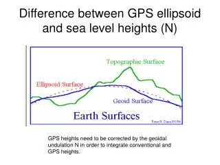
Difference between GPS ellipsoid and sea level heights (N). GPS heights need to be corrected by the geoidal undulation N in order to integrate conventional and GPS heights. Geoid03 heights from the National Geodetic Survey.

Difference between GPS ellipsoid and sea level heights (N)
E N D
Presentation Transcript
Difference between GPS ellipsoid and sea level heights (N) GPS heights need to be corrected by the geoidal undulation N in order to integrate conventional and GPS heights.
Counties (red), railroads (green) and NGS (geoid control points for GEOID03 (black) Area of interest
Free-air gravity anomalies of West Texas (used for geoidal computations) (CI=6 mgals) Proposed road NGS geoid control are black triangles. Approximately 6 mgal gravity change results in about 2cm geoid undulation. Note sparse data along the western part of road. Geoid control are used to force N surface through those known N values so if control and/or gravity data are sparse then N is less reliable. .
Elevation of gravity stations(approximate topography)(Contour interval 5 meters) Note similarity to Free-air gravity anomalies.
Computing geoidal corrections • Gravity data ( a version of the Free-air gravity anomaly) is used to compute the surface of the equipotential of gravity representing sea level, the geoid. • GPS heights H are corrected by the geoid undulation correction N by h (geoid height)=H+N • The surface N is then MODIFIED with a CORRECTOR SURFACE consisting of locations where both sea level (geoid) heights and GPS heights are known, which is N (considered control points).
Reliability of geoid corrections • The reliability of the geoid computation is dependent on the distribution of the gravity data—data gaps are interpolated across— • If sparse gravity data-- less reliable. • Another reliability factor is corrector surface. • If widely spaced control, incorrect corrector surface.
Recommendations • Gravity and control data in Big Bend area are most sparse and Free-air gravity anomalies and topography the most variable. • Therefore original gravity values and corrector surface are less reliable. • For 1 minute (lat/lon) grid prefer approximate 1 minute data distribution.
Recommendations • Coordinate with NGS • At least--add regionally distributed gravity data in the west • along railroad/road. • Fill in data gaps at 1-5 km spacing along and on both sides of route. • 10-20 stations/day—20 days. • Idea--Use university during the summer. • Then provide data NGS to compute geoid or university could do it. Integrate with Geoid03.