Download
1 / 1
60 likes | 328 Vues
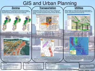
GIS and Urban Planning. Zoning. Transportation. Utilities. Zoning is the process of categorizing land tracts according to their intended use. Common types of zones include commercial, industrial, recreational, and various levels of residential.

E N D
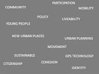
GIS and Urban Planning Zoning Transportation Utilities Zoning is the process of categorizing land tracts according to their intended use. Common types of zones include commercial, industrial, recreational, and various levels of residential. Transportation within urban areas is crucial as it allows for the movement of people from place to place. Airports, highways, railways, and public transportation systems all play vital roles in the city. Without utilities, no modern-day urban area would be able to function. Water, gas, electricity, and sewage among others are crucial to the growth and survival of the city. Source: http://www.esri.com/events/gita/index.html Source: http://www.esri.com/industries/transport/business/airports.html Source: http://www.esri.com/industries/transport/business/airports.html Familiarity of all utilities are very important when it comes to building new property, repairing a damaged system, or constructing a new one. Incorporating GIS data into a 3-D visualization output can help to achieve a full understanding of the orientation of pipelines and cables in all directions with respect to the ground above. Along with traffic and the associated pollution from emissions, another type of pollution emerges: noise. Highways, major freight lines, and commercial airports are among the largest producers of noise pollution. McCarran International Airport in Las Vegas is located adjacent to the area known as the Strip. Based on the alignment of the runways, GIS can be used to visualize which areas of the city receive noise from arriving and departing airplanes. San Antonio’s Broadway Corridor is undergoing plans to diminish the number of assembly districts and add more park space and community residences. Using GIS, the current land use tracts of every block along the corridor can be visualized along with future projections of what the area may look like. This allows for a comparison to be performed to help appeal to the approval of contractors and city ordinances. Source: http://www.epwu.org/water/water_rights.html Source: http://www.orcity.org/gis-mapping/ The El Paso Water Utilities Service obtained a 75-year lease from property owners to supply the city with water from the Rio Grande. In doing so, three different grant areas were established. Mapping these areas affirms the exact geographic areas where property owners are to be compensated for the city’s use of their surface water sources. Source: http://www.chesapeake.va.us/services/depart/infotech/gis/maps.shtml The city of Oregon City, OR uses GIS for a 3-D zoning visualization. By combining land use data with building height and topographic data, it can clearly be seen where certain zones exist with respect to terrain. Improvements in city planning can be performed much more easily given this information. Chesapeake, VA is proposing transportation corridors along two major routes in the city. Mapping one-mile wide corridors shows exactly which areas will benefit from new development and increased transportation accessibility. Pros of GIS Cons of GIS Sources and References • GIS can help greatly to visualize data that could be very difficult to perceive otherwise. • Acquiring and processing data may cost a great amount of time and money to carry out. ESRI, Inc. http://www.esri.com City of Chesapeake, VA http://www.chesapeake.va.us/services/depart/infotech/gis/maps.shtml City of Oregon City, OR http://www.orcity.org/gis-mapping/ El Paso Water Utilities http://www.epwu.org/water/water_rights.html Background image acquired from Johnnyroadtrip.com http://www.johnnyroadtrip.com/cities/newyork/ • GIS is a multi-layer tool; it can combine multiple data sets and put them into one database. • GIS requires trained experts and/or time to train people to become familiar with the system Armand Silva GEOG 363 Section 4