Download
1 / 8
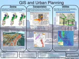
Urban Visualization: Enhancing City Planning with GIS Technology
90 likes | 245 Vues
Explore the cutting-edge use of GIS technology in urban visualization for city planning, terrain analysis, and line of sight studies. Learn about spatial situational awareness and urban model simplification techniques. Discover new projects including LIDAR change detection and Charlotte Light Rail TOD. This project, led by Thomas Butkiewicz, Zachary Wartell, and Remco Chang, aims to revolutionize how urban information is visualized and utilized.
Télécharger la présentation 
Urban Visualization: Enhancing City Planning with GIS Technology
An Image/Link below is provided (as is) to download presentation
Download Policy: Content on the Website is provided to you AS IS for your information and personal use and may not be sold / licensed / shared on other websites without getting consent from its author.
Content is provided to you AS IS for your information and personal use only.
Download presentation by click this link.
While downloading, if for some reason you are not able to download a presentation, the publisher may have deleted the file from their server.
During download, if you can't get a presentation, the file might be deleted by the publisher.
E N D
Presentation Transcript
GIS and Urban Visualization Thomas Butkiewicz PhD Candidate Zachary Wartell Assistant Professor Remco Chang Research Associate
New Projects • LIDAR Change Detection (Tom Butkiewicz) • City Planning: Charlotte Light Rail TOD (Zach Wartell)


More Related