Mission Operations, Ground and Data Systems
Mission Operations, Ground and Data Systems. Section G.7. Geosat Ground System, JHU/APL & NOAA. Tossman Marth Porter. Cheney Porter. NOAA Role in ABYSS Data Processing & Archive. Figure F-13. NOAA GDR Production & Data Archive. Laboratory for Satellite Altimetry GEOSAT mission 1985-1989

Mission Operations, Ground and Data Systems
E N D
Presentation Transcript
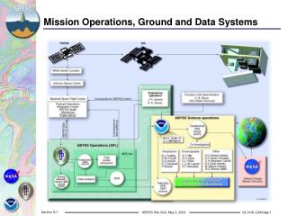
Mission Operations, Ground and Data Systems Section G.7
Geosat Ground System, JHU/APL & NOAA Tossman Marth Porter Cheney Porter
NOAA Role in ABYSS Data Processing & Archive Figure F-13
NOAA GDR Production & Data Archive Laboratory for Satellite Altimetry GEOSAT mission 1985-1989 Release of Geodetic & Exact Repeat Data in 1997 Dissemination & Archive of Geosat Follow-On GDRs National Oceanographic Data Center Production & Distribution of GEOSAT CD-ROMs Archive for SDR and GDR data from GEOSAT National Geophysical Data Center Smith & Sandwell Predicted Bathymetry products GEOSAT Gravity Anomaly posters & data sets
Altimetry Data on CD-ROM Geosat JGM-3 GDRs Geodetic Mission Declassified 1995 10-CD GDR data set released 1997 Wind/Wave and Altimetric Crossover data also available on CD Geosat Follow-On - Launched February, 1998 Hardware failures severely slowed acceptance & Cal/Val Laser orbits replaced primary GPS system which failed Currently processing high quality data set from Dec.’99 to date
GDR Processing Combine Range and GPS Orbits Determine Sea Surface Heights Compute Sea Surface Slopes Include along- and cross-track attitudes from D2P Apply Atmospheric Path Delay Corrections Wet troposphere (total precipitable water) Dry troposphere (sea level pressure) Ionosphere from GPS-based GIMs Add corrections for Sea Surface Effects Ocean, Load, and Solid Earth Tides Sea State Bias Inverse Barometer Final Datasets on CD/DVD Format follows CCSDS standards (JASON/ENVISAT) GDR and GDR+Waveform data NOAA / NCEP NASA / JPL
NODC / NGDC Archives Official “Deep” Permanent Archives Adherence to NARA Standards Telemetry, SDR, GDR, and Orbits at NODC Surface Slope, Gravity, Bathymetry and High Level Science Products at NGDC Archive at NASA Global Change Master Directory