
Puget Sound Mapping Project Tutorial
E N D
Presentation Transcript
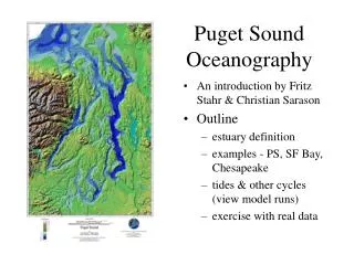
Puget Sound Mapping Project Tutorial October 2017
Part of EPA National Estuary Program Part of a larger effort in Puget Sound http://www.psp.wa.gov/NEP-overview.php Grant to Commerce/Ecology Watershed characterization Strategies to manage stormwater Strategies for protecting and restoring watersheds Land use and working lands Project Objectives
The Washington State Department of Commerce (Commerce) believes in the importance of the public’s right to know about its operations and activities. Commerce prepares and uses this data and information as a conceptual tool. GIS Data is intended to be used as a GUIDE. These maps were created from available public records and existing map sources, and from different surveyors and their surveys. Map features from all sources have been adjusted to achieve a ‘best fit’ registration to the Zoning of parcels. While great care was taken in this process, maps from different sources rarely agree as to the precise location of geographic features. The relative positioning of map features to one another results from combining different map sources without field ‘ground truthing’. This data and information may contain aggregate, anonymous statistics. This data and information should not be construed, express or implied, as legal advice or legal opinion on any specific facts or circumstances. Commerce discloses this data and information as-is without any warranty, and Commerce expressly disclaims all express or implied warranties of merchantability and fitness for a particular use. The burden for determining fitness for use lies entirely with the user. In no event shall the Commerce have any liability whatsoever for payment of any consequential, incidental, indirect, special, or tort damages of any kind, including, but not limited to, any loss of profits arising out of use of or reliance on the geographic data or arising out of the delivery, installation, operation, or support by Commerce. No public agency, public official, public employee, or custodian shall be liable, nor shall a cause of action exist, for any loss or damage based upon the release of a public record if the public agency, public official, public employee, or custodian acted in good faith in attempting to comply with the provisions of Washington’s Public Records Act. Commerce reserves the right to alter, suspend, re-host, or retire this service at any time and without notice. This service can be used in custom web applications and software products. Your use of this service in these types of tools forms a dependency on the service definition (available fields, layers, etc.). If you form any dependency on this service, be aware of a significant risk to your purposes. Consider mitigating your risk by extracting the source data and using it to host your own service in an environment under your control. Project Objectives - Disclaimer
Annual population increase has tripled 29,203 new residents from 2010-2011 99,540 new residents from 2015-2016 Percentage of growth by county is staying about the same 50% in King County 13% outside of King, Pierce, Snohomish, Kitsap & Thurston Percentage of growth in King County located in Seattle is increasing 40% between 2010 and 2011 57% between 2015 and 2016 Recent Trends Twelve (12) Washington State counties that reach the Salish Sea (The Puget Sound, the Strait of San Juan de Fuca, and the Strait of Georgia in Canada)
Create standardized and integrated map of Puget Sound 12 counties 113 cities Show zoning and land use patterns (2012) Integrate data on new housing development OFM Small Area Population Estimates Project Objectives
Show large scale growth patterns within watersheds and sub-basins floodplains incorporated v. unincorporated urban growth areas v. rural land use categories Project Objectives
Assist with regional planning and watershed recovery efforts Track progress on indicators Support grant applications Target mitigation projects Project Objectives
Provide tool for local planning evaluate land use/zoning “performance” are “centers” capturing growth is growth clustering along transit corridors are some areas capturing more growth than others is growth happening in vulnerable sub-basin areas Project Objectives
Provide tool for local planning Depict existing conditions and trends Show vulnerable areas Prioritize recovery measures septic replacement/sewer extensions land acquisition, restoration sites, etc. adjusting stream buffers, clearing allowances, etc. Project Objectives
Zoning categorization 13 Master Categories 32 “Nested” Sub Categories Project Description
The PSMP mapping tool can be used by local governments, special purpose districts, state and federal agencies, legislative staff, consultants and the public to: Assess growth patterns and trends over time; Help support decisions related to development projects, urban growth boundaries, and the need for environmental protection measures; Allow integration with Puget Sound Basin watershed characterization data and other data resources; Help support and strategically target compensatory mitigation actions. Project Description – Purpose of the Map
Click on an item to see “pop-up” details. Pop-upsprovide a detailed, stylized view of attribute data associated with a specific layer. They provide relevant and contextual information of the data. Exploring the Map – Pop-up Details
Exploring the Map – Zoom/Pan Zoom (+ or -), Home/Default Extents, and Find My Location tools Hold down the left mouse button to Pan
The Extract Datatool is a convenient way to package the layers in a map into datasets that can be used in ArcGIS Desktop, Excel, and other products. Limitations: • Extractable layers include layers that the user owns and layers where export has been enabled. • When exporting lines or areas to a CSV file, only non-spatial attributes are extracted. • Attachments will only be extracted if the output data format is a file geodatabase and Clip features is unchecked. Extracting Data
The Extract Datatool gives many options when exporting data, including the option to export features that are in a study area the user defines. If the user wants to extract the entire dataset to a shapefile or CSV file, the Extract Data tool can also be used. Extract Data creates an item in Content containing the data in the layers panel. The data can then be downloaded from the item created. Extracting Data
1 Extract Data Click the icon Select the tab Select Extracting Data 2 3
Select layers to extract for export. Only layers that the user owns or that the owner has enabled for export can be selected. A study area must be selected from which your data is extracted. The boundary can be the visible extent of your map (Same as Display), the extent of one of your layers, for a specific area of interest, or a custom boundary created using the Draw tool. Extracting Data
Features within the boundary can be extracted based on one of two methods: Select Features or Clip Features. Output data formats are as follows: CSV, File geodatabase, KML, and Shapefile. Extracting Data
If boundaries are staying the same and only attribute designations are changing – start editing the layer and enter the revised designation directly into the attribute table, as follows: Open the map in Map Viewer that contains the feature layer you want to edit, ORopen the feature layer in a new map by clicking Click on the tab. Update the Map – Approach #1
3. To edit the attributes of an existing feature, click it on the map to select it and open the pop-up. Click on the Edit tab at the bottom right corner of the pop-up. Update the Map – Approach #1
4. Change the necessary Attribute details. Update the Map – Approach #1 5. Click Close in the pop-up when you finish editing. (For more information, go to http://doc.arcgis.com/en/arcgis-online/create-maps/edit-features.htm)
Create a Clip of the area to update (i.e. Extract Data as described previously) • Erase the clip area from the original map • Prepare a new map for area with revision (or expansion) • new .zip shapefile to the New Map Update the Map – Approach #2
shapefile as a Feature Layer Update the Map – Approach #2 Feature Layer Shapefile
Select the Feature Layer and edit Settings to Enable Editing Update the Map – Approach #2
4. Update the New Map: • Use Symmetrical Difference in GIS or Compare Documents in PDF • Enter an editing session and manipulate the existing polygon boundaries to conform to new shapes • Split polygons to create new areas and enter the appropriate classifications in the attribute fields • In new areas – ensure there are attribute columns for Master and Subcategory • o Make assignments based upon the Land Use Designation guidelines. • o If ROW layer does not exist – create it using gaps or create 60 foot ROW width from lines using the Buffer tool. • 5. Mergethe new map with the base map. Update the Map – Approach #2
Select polygons that fall within the area of analysis (*Note – polygons that fall along boundaries will result in an undetermined margin of error in calculations – to minimize this error, fully include all polygons even if they extend beyond the analysis area boundaries.) Export records into a new shapefile or feature class. (If the analysis area and clip area are coterminous and you don’t need to summarize growth by sub-areas, attribute or date ranges – you can right click on the attribute column and toggle the summarize option to see the total amount of growth for that column.) Determine the Amount of Growth
Create a Union between the new shapefile and the analysis area boundary. Determine the Amount of Growth
Create a new ‘Float’ attribute field called JoinID and calculate attribute value by using FID + 1 Select all records, enter the attribute table, click on highlighted/selected records and click Copy. Open an Excel table and Paste the attribute table into Excel Summarize data using Excel formulas, as desired, to derive growth estimates, land use categories or date ranges. Determine the Amount of Growth
Presented by: Allan Johnson Commerce Specialist 3 Puget Sound Mapping Project Washington State Department of Commerce 360.725.5033d Cap Allocation Program Allan.johnson@commerce.wa.gov www.commerce.wa.gov