Download
1 / 16
160 likes | 292 Vues
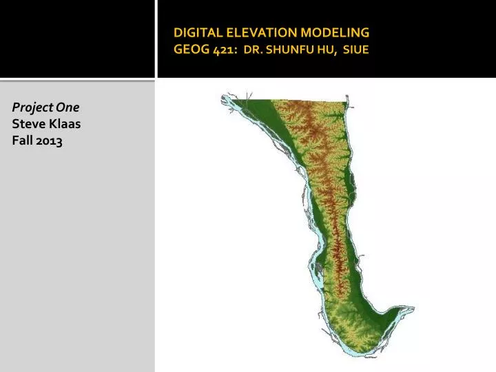
DIGITAL ELEVATION MODELING GEOG 421: DR. SHUNFU HU, SIUE. Project One Steve Klaas Fall 2013. Introduction. Digital Elevation Model Calhoun County, Illinois. Project One Study Area: Calhoun County Elevation Data: Two 30m NED DEM files (. tif ) Steps: Data Preprocessing

E N D
DIGITAL ELEVATION MODELINGGEOG 421: DR. SHUNFU HU, SIUE Project One Steve Klaas Fall 2013
Introduction Digital Elevation Model Calhoun County, Illinois Project One Study Area: Calhoun County Elevation Data: Two 30m NED DEM files (.tif) Steps: Data Preprocessing Terrain Preprocessing Terrain Processing Stream Network Analysis Watershed Boundaries Hydrological Modeling Comparison with Real Data
Data Sources USDA NRCS: http://datagateway.nrcs.usda.gov • NED 30m DEM (2 Images in TIF format) • US Census County Outline • NHD Rivers, Water Bodies, Streams • USDA SSURGO Soil Data • NLCD Land Use/Land Cover NOAA Meteorological Data: http:www.ncdc.noaa.gov-.url • Hourly Precipitation Totals USGS River Gage Data: http://waterdata.usgs.gov/nwis/ • River and Stream Gage Data
MethodologySpatial Analyst Tools DEM Data Preprocessing Project Raster: Illinois State Plane West-Feet Convert Z units to Feet using Raster Calculator Convert to Integer Data Type Build Raster Attribute Table
MethodologyData Management Tools Mosaic and Format Transformation Mosaic to New Raster GRID format DEM
MethodologySpatial Analyst Tools Subset Image to County Line using Extract by Mask Tool Mosaic to New Raster Tool Output: GRID format DEM subset to shape of county Reduces DEM size Improves Processing Time
MethodologySpatial Analyst Tools Hillshade Tool Contour Tool
MethodologySpatial Analyst Tools Aspect Tool Slope Tool
ArcHydro Tools Extension for ArcGIS Available for free from Army Corps of Engineers Simplifies Data Processing tasks for Hydrology
Stream Network Analysis Left: Drainage Lines Right: Drainage Points
Flow Accumulation Darker color indicates greater flow
Flow Direction Color indicates the direction of overland flow
Watershed Boundaries Model allows user to choose points, providing watershed definition for each point.
Conclusion • The project successfully modeled the hydrology of Calhoun County, Illinois. • Skills Acquired: • Acquisition, Data Preparation, and Processing of National Elevation Dataset DEMs. • Hydrology work flow using the ArcHydro Tools extension. • Deliverables Provided: • Slope Map • Aspect Map • Hillshade Map • Stream Definition • Drainage Line Definition • Drainage Point Definition • Flow Direction Definition • Flow Accumulation Definition • Watershed and Catchment Delineation