Download
1 / 44
440 likes | 674 Vues
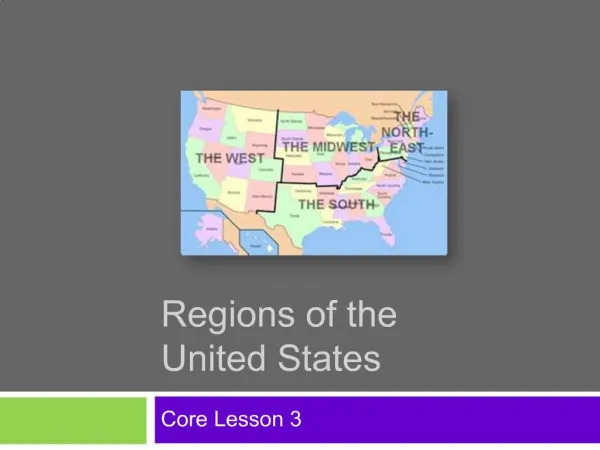
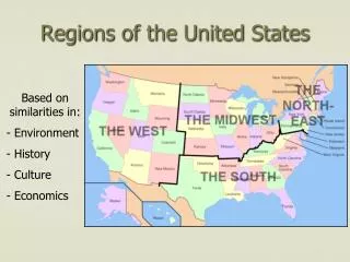
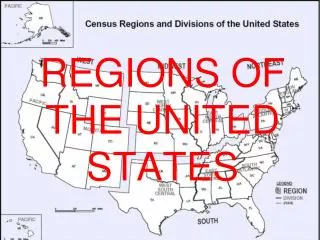
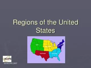
Regions of the United States. Instructions. One map outline or circle each region with a different color. Write down two characteristics for each region. At the end of the presentation, draw a picture for each region, then turn it in. Class Outline. Northeast South Midwest &Great Plains

E N D
Instructions • One map outline or circle each region with a different color. • Write down two characteristics for each region. • At the end of the presentation, draw a picture for each region, then turn it in.
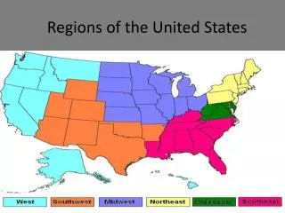
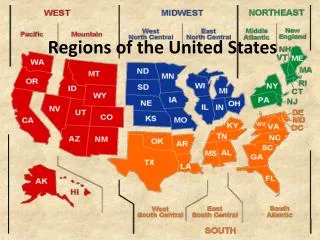
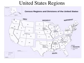
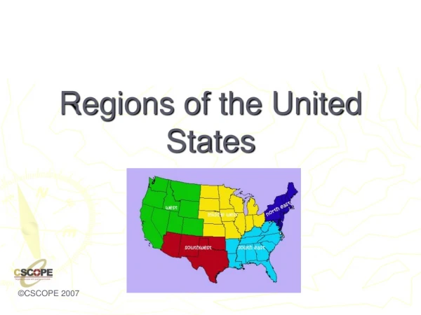
Class Outline • Northeast • South • Midwest &Great Plains • Rocky Mountains/Basin States, including Southwest • Pacific Coast
The Northeast • Northeast • Maine, New Hampshire, Vermont, Massachusetts, Connecticut, Rhode Island, New York, New Jersey, Pennsylvania, Delaware, Maryland, and the District of Columbia
Population Concentration • Population is concentrated in the Megalopolis that runs from Boston to Washington (AKA Boswash). • This is the most densely populated region in the United States.
Major Cities • New York City,NY • 8,391,881 people • Philadelphia, PA • 1,547,297 people • Boston, MA • 645,169 people
Features of the Northeast Northern Appalachian mountains run through most of the northeastern states, causing little farmland, except in valley areas. The Northeast has the longest history of European settlement . Historically, the Northeast has been the gateway to immigrants.
Land Use in the Northeast Dairy Farming (think Vermont…) Farming Timber Maritime Activity Some mining Note: As you go north, the growing season shortens, which limits farming. In part of the Northeast, timber is a primary economic activity.
Characteristics • The Mid-Atlantic states dominate the financial sector of the U.S., advertising, manufacturing. • This region is the home to most major corporations in the United States. corporation
The South • States included: North Carolina, South Carolina, Florida, Georgia, Alabama, Mississippi, Tennessee, Arkansas, and Louisiana • Transition States: Virginia, W. Virginia, Kentucky, Missouri, Oklahoma, and Texas
Population Geography of the South • The South’s population is evenly distributed, except increase in density around urban centers. • Examples: Atlanta, New Orleans, Houston, Dallas Miami
Physical Geography of the South • Dominated by a wide coastal plain, meandering river basins • What is the most prominent river basin in this region? • Where is its delta? Delta
Climate and Vegetation of the South • Humid subtropical, with hot, humid summers and long growing season. Winters are mild, seldom with snow. There is no dry season.
Historical Geography of the South • The South was settled as an agricultural region, with slavery and cash crops as its driving force. The climate and physical landscape were well suited for an agricultural society. • Historically, the South was settled by many different cultures, although the Anglo Protestant plantation farmers were the dominant group. • Other cultures included: Spanish, Caribbean, Creole, Cajun
Economic Geography of the South • Historically based on agriculture, with tobacco and cotton being the first cash crops. • Although agriculture has dominated the economy, service industry, manufacturing, and high tech industries are also located in the South. manufacturing Hi tech industry
Music of the South • The South is the origin all types of music: • Rhythm and Blues • Jazz • Bluegrass • Appalachian Folk Music • Gospel • Country music • Rock n Roll (Elvis/Memphis)
Midwest • Included States: Michigan, Ohio, Indiana, Illinois, Wisconsin, Minnesota, and Iowa • Transition States: Pennsylvania, Missouri
Population • Large cities include Chicago and Detroit • The region is evenly distributed. • Population is dense along the Great Lakes.
Physical Geography of Midwest Flat landscape, with river basins. Distinctive Great Lakes, which provide for shipping. Humid continental climate
Historical Geography of the Midwest • Historically known as the breadbasket of the U.S., as this is also an agricultural region. • Also known as a manufacturing, blue-collar hub of the U.S. Working class, manual labor
Economic Geography • Dairy Farming in Wisconsin and Minnesota • Fruit Orchards in Michigan • Corn in Indiana, Illinois, and Iowa • Manufacturing in urban cities along Great Lakes, like Pittsburgh, Cleveland, Detroit and Chicago (Steel Towns).
Breadbasket of the USA • Corn is most notably grown, but soybeans, wheat, and fruits orchards are also commonly found throughout the Midwest. • Dairy products are famous in which state in the Midwest?
Cultural Geography • Home to various immigrant groups, which causes ethnic, racial, and religious diversity in the cities. • Cuisine reflects the cultural and physical diversity: Chicago style pizza, Polish bakeries, Wisconsin cheese, and Michigan’s apple cider mills and fruit orchards.
Great Plains Region • Strip of States through the center of the country • Includes: Kansas, Nebraska, South Dakota, and North Dakota • Transition States: Oklahoma, Panhandle of Texas, Eastern Colorado, Wyoming and Montana
Physical Geography of the Great Plains • Generally flat with some rolling hills (Steppe Climate) • Major River Basins: Red R., Arkansas River, Platte River, and the Missouri River
Historical Geography of the Great Plains • Before Americans settled the frontier, the Great Plains was home to several indigenous cultures, most notably the Sioux, the Cheyenne, and the Arapaho.
More on Historical Geography • The Great Plains was also used for cattle grazing and cattle drives. • Many of the cities in this area were founded as railroad hubs for cattle.
Population of the Great Plains Two words: Rural and declining
Economic Activity • Wheat – another important crop (the Dakotas) • spring wheat major crop in the north • winter wheat (Kansas) • Associated with wheat are sorghums, barley, and livestock production
Ogallala (High Plains) Aquifer • Because there is little rainfall, farmers use the aquifers to irrigate crops. The Ogallala is one of the largest in the U.S., but it is being depleted at a high rate. Aquifer - An underground layer of water-bearing porous stone, earth, or gravel
Mountain and Basin States • States included: New Mexico, Colorado, Wyoming, Montana, Idaho, Utah, Nevada, Arizona
Population Geography • Not densely populated • Major urban centers include: Denver, Salt Lake City, Phoenix
Physical Geography • Characterized by the steep and jagged Rocky Mountain Range, foothills of the Rockies, High Deserts and Intermountain Basins • Diverse physical region, including landforms and climates
Historical Geography • Mining towns • Outlaws (Wild West) • Cattle/Sheep Grazing • Reservation Lands • Las Vegas and Reno- Gambling towns • National Park Service
Economic Activity • Grazing • Mining • Tourism • Lumber
Cultural Heritage of the West • Old Mining ghost towns exemplify the culture of the mountain states. • Mountain towns are known for their transient population, seasonal employment, and influx of tourists. • Likewise, the Basin states are home to the largest number of National Parks.
Pacific Coast States • California, Oregon and Washington • Alaska and Hawaii will be covered separately.
Population Geography • More dense along the coastal areas, especially between San Diego, LA, and San Francisco • Other urban centers exist around Seattle and Portland.
Physical Geography of West Coast • Mountain Ranges (Sierra Nevada and the Cascades) and Rocky coastlines due to Subduction forces • Fertile valleys (San Joaquin) and forests in northern areas that receive more rainfall • Physical hazard exist across the region due to tectonic forces.
Economic Activity • Hi-tech Industry • Movie Industry • Farming in the San Joaquin Valley • Wine (Napa and Sonoma) • Tourism • Fishing on the coast