Download
1 / 40
450 likes | 769 Vues
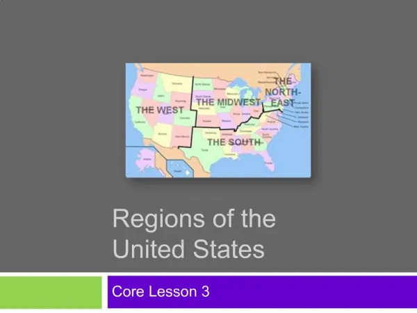
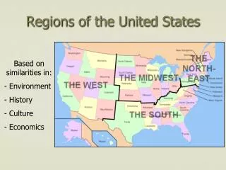
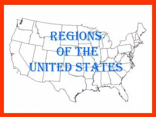
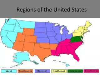
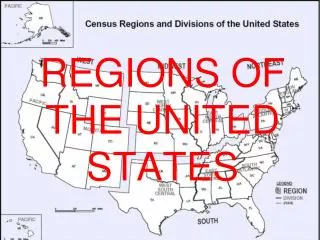
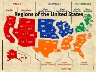
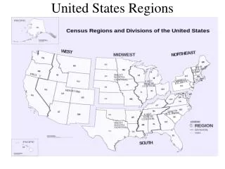
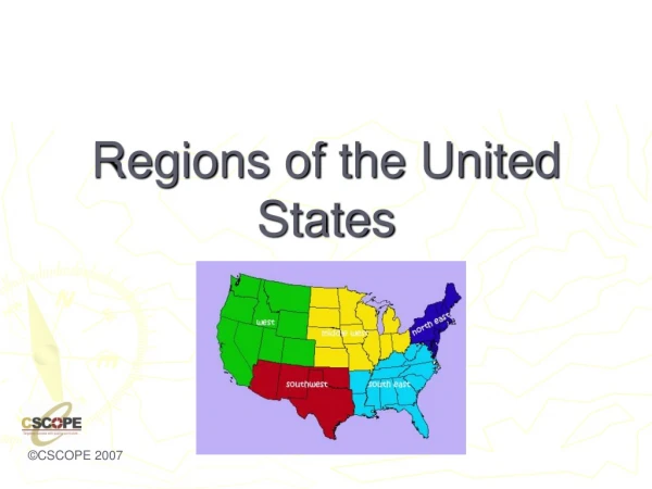
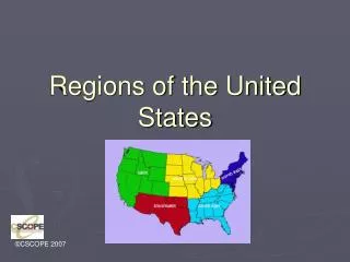
Regions of the United States. Class Outline. Northeast South Midwest West. The Northeast. Northeast Maine, New Hampshire, Vermont, Massachusetts, Connecticut, Rhode Island, New York, New Jersey, Pennsylvania, Delaware, Maryland, and the District of Columbia.

E N D
Class Outline • Northeast • South • Midwest • West
The Northeast • Northeast • Maine, New Hampshire, Vermont, Massachusetts, Connecticut, Rhode Island, New York, New Jersey, Pennsylvania, Delaware, Maryland, and the District of Columbia
Physical Geography of Northeast • Northern Appalachian mountains run through most of the northeastern states, causing little farmland, except in valley areas. • Deep bays exist, allowing for port towns. • Jagged, rocky coastline in northern areas.
Climate and Vegetation of Northeast: Humid Continental • No Dry Season- this area receives precipitation throughout the year. • Cold, snowy winters and hot summers. • Moderate growing season that decreases as you go north. • Vegetation is mixed forests with deciduous and coniferous trees.
Historical Geography of the Northeast • The Northeast has the longest history of European settlement . • Historically, the Northeast has been the gateway to immigrants. • Established itself as the financial and manufacturing hub early in the industrial revolution.
Population Geography of the Northeast • Population is concentrated in the Megalopolis that runs from Boston to Washington (AKA Bosnywash). • This is the most densely populated region in the United States.
Land Use in the Northeast • Dairy Farming • Farming • Timber • Maritime Activity • Some Mining • Note: As you go north, the growing season shortens, which limits farming. In part of the Northeast, timber is a primary economic activity.
Economic Geography • Northeast is the heart of the Manufacturing core, but lately has been termed the RUST BELT. This extends into the Midwest. • Why do you think it’s called the Rust belt? Where have industries relocated? Why?
New England Legacy • New England is famous for its “prep schools” and is home to some of the most elite Universities in the world: Harvard, Yale, MIT, Boston College, Brown, and Dartmouth (just to name a few). • One of the best resources New England has is its educated population.
New England Politics • New England is generally progressive in politics and states usually are affiliated with the Democratic party, although some rural areas tend to vote Republican.
The South • States included: North Carolina, South Carolina, Florida, Georgia, Alabama, Mississippi, Tennessee, Arkansas, and Louisiana. • Transition States: Virginia, W. Virginia, Kentucky, Missouri, Oklahoma, and Texas
Climate and Vegetation of the South • Humid subtropical, with hot, humid summers and long growing season. Winters are mild, seldom with snow. There is no dry season. • Vegetation: Mixed forests. The South is known for plants such as live oaks, magnolia trees, flowering dogwoods.
Economic Geography of the South • Historically based on agriculture, with tobacco and cotton being the first cash crops. • Fishing is a common activity in Gulf Coast States. • Tourism along the Gulf Coast, especially Florida. • Oil Industry is located in the Gulf and in cities like Houston and Beaumont, close to continental shelf drilling.
Political Activity • The South is known for its conservatism. • The Republican Party dominates the South as a result. • Resistance to same-sex marriage, abortion, feminism, desegregation, and the abolition of slavery are part of the political history of the South.
Midwest • Included States: Michigan, Ohio, Indiana, Illinois, Wisconsin, Minnesota, and Iowa • Transition States: Pennsylvania, Missouri
Physical Geography of Midwest Flat landscape, with river basins. Distinctive Great Lakes, which provide for shipping.
Climate of the Midwest: Humid Continental • No Dry Season- this area receives precipitation throughout the year. • Cold, snowy winters and hot summers. • Moderate growing season that decreases as you go north. • Vegetation is mixed forests with deciduous and coniferous trees.
Historical Geography of the Midwest • The Mid-west was considered the “Western Frontier”, hence the name. • Historically known as the breadbasket of the U.S., as this is also an agricultural region. • Also known as a manufacturing, blue-collar hub of the U.S.
Population • Large cities include Chicago and Detroit • The region is evenly distributed. • Population is dense along the Great Lakes.
Economic Geography • Dairy Farming in Wisconsin and Minnesota • Fruit Orchards in Michigan • Corn in Indiana, Illinois, and Iowa • Manufacturing in urban cities along Great Lakes, like Pittsburgh, Cleveland, Detroit and Chicago (Steel Towns).
Breadbasket of the USA • Corn is most notably grown, but soybeans, wheat, and fruits orchards are also commonly found throughout the Midwest. • Dairy products are famous in which state in the Midwest?
Great Plains Region • Strip of States through the center of the Country. • Includes: Kansas, Nebraska, • South Dakota, and North Dakota. • Transition States: Oklahoma, • Panhandle of Texas, • Eastern Colorado, Wyoming • and Montana. ,
Physical Geography of the Great Plains • The Great Plains are also called the High Plains, as the elevation increases gradually as you go west. • Generally flat with some rolling hills. • Major River Basins: Red R., Arkansas River, Platte River, and the Missouri River.
Climate of the Great Plains • This area receives little rainfall (less than 18 in. a year on average). • Cold Winters, especially in the northern areas.
Historical Geography of the Great Plains • Before Americans settled the frontier, the Great Plains was home to several Indigenous culture, most notably the Sioux and the Cheyenne. • During the 19th century, the Great Plains became the staging point of war between the native people and the American settlers.
Homestead Act of 1862 • This act provided each settler with 160 acres of land, as long as he cultivated the land. • This caused a rush of settlers to the Great Plains region in the 1800s. • Ironically, the Great Plains has lost a third of its population since 1920. Kansas has 6,000 ghost towns.
Population of the Great Plains Two words: Rural and declining.
Mountain and Basin States • States included: New Mexico, Colorado, Wyoming, Montana, Idaho, Utah, Nevada, Arizona • Transitions: Colorado, Wyoming and Montana are also Great Plains States • Southwest: Texas, New Mexico, Arizona, Southern Utah/Nevada.
Physical Geography • Characterized by the steep and jagged Rocky Mountain Range.
Climates • Highland climate is found throughout the Rockies • Deserts • In general, the area is arid. • Farming is done with irrigation.
Historical Geography • Mining towns • Outlaws (Wild West) • Cattle/Sheep Grazing • Reservation Lands • Las Vegas and Reno- Gambling towns • National Park Service
Population Geography • Not densely populated. • Major urban centers include: Denver, Salt Lake City, Phoenix.
Economic Activity • Grazing • Mining • Tourism • Lumber
Pacific Coast States • California, Oregon and Washington
Physical Geography of West Coast • Mountain Ranges (Sierra Nevada and the Cascades) and Rocky coastlines due to subduction forces. • Physical hazard exist across the region due to tectonic forces.
Southern California • The continual presence of natural hazards, including fire, flood, earthquakes, and intense drought, has done little to reduce the growth of this area • San Andreas Fault • Los Angeles is the 2nd largest city in the U.S.
Population Geography • More dense along the coastal areas, especially between San Diego, LA, and San Francisco. • Other urban centers exist around Seattle and Portland.
Economic Activity Movie Industry • Wine (Napa and Sonoma) • Tourism • Fishing on the coast
Western Politics • The West coast states are known for their liberalism in politics. • Examples: Oregon has legalized euthanasia, all have legalized medicinal marijuana, California recognizes same-sex marriage