Download
1 / 21
210 likes | 338 Vues
INNER CORE STRUCTURE AND INTENSITY CHANGE IN HURRICANE ISABEL (2003). Shuyi S. Chen and Peter J. Kozich RSMAS/University of Miami J. Gamache, P. Dodge, F. Marks NOAA/AOML/HRD 27 th AMS Tropical & Hurricane Conference, April 23-28, 2006, Monterey, CA.

E N D
INNER CORE STRUCTURE AND INTENSITY CHANGE IN HURRICANE ISABEL (2003) Shuyi S. Chen and Peter J. Kozich RSMAS/University of Miami J. Gamache, P. Dodge, F. Marks NOAA/AOML/HRD 27th AMS Tropical & Hurricane Conference, April 23-28, 2006, Monterey, CA.
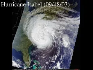
12-14 Sept 2003 LF Radar Reflectivity (dBZ) Composite from NOAA-42 RF 9/12 1644-1709 UTC 9/13 1625-1650 UTC 9/14 1822-1852 UTC 9/12 2000-2030 UTC 9/13 1915-1945 UTC 9/14 2157-2222 UTC http://www.aoml.noaa.gov/hrd/Storm_pages/isabel2003/radar.html
What has been observed in Isabel? • significant inner core structure changes • concentric eyewalls • mesovortices in the eye • What role do they play in Isabel’s intensity and intensity change?
Model and Data 45km • PSU-NCAR MM5 (nested domains with 45,15,5, and 1.67 km grid resolution, 28 sigma levels, Chen and Tenerelli 2006) • NCEP global analysis fields as initial and lateral B.C. • Vortex relocation scheme (Liu et al 1997) • NOAA/HRD airborne Doppler radar, flight-level, and GPS dropsonde data 15 5 1.6
Isabel Tracks, from Best Track and MM5 Investigation focuses on time frame between arrows; observation and model times are different
Intensity (minimum SLP) Investigation focuses on time frame between arrows
Idealized barotropic model (Schubert et al. 1999, Kossin et al. 2000) Evolution of a single primary eyewall Evolution of primary + secondary eyewalls (Kossin et al. 2000)
14th 14th 13th 13th 12th 12th Hovmoller Diagrams of Azimuthal Averaged MM5 Rainrate and Tangential Windspeed at 2km Level
Observed and Model Simulated Tangential Wind Speed (ms-1) at 1-km level 9/129/139/14 Radar MM5
Azimuthally Averaged Reflectivity 9/12913914 Radar MM5
Flight Level Wind (Blue) and MM5 Wind (Red) at 2km level 9/12913914 mean mean mean mean
Relative Vorticity (x 10-3 s-1) at 1-km level 9/129/13 9/14 Radar MM5
Potential Vorticity at 1-km Level 0600 Z 9/11 1200 Z 1800 Z 0000Z 9/12 0600 Z 1200 Z 1800 Z 0000Z 9/13 0600 Z 1200 Z 1800 Z 0000Z 9/14
Inertial Stability Analysis Hack and Schubert (1986): IS = [(f + 2V/r)(f + )] 1/2 = [(f + 2V/r)(f + V/r + V / r)] 1/2
RMW 9/12/03 V(r) • Intensifying storm • Highest flight-level winds with a sharp bell-shaped profile • High inertial stability (IS) inside of the eyewall • Strong eyewall updrafts and convection • Secondary wind max IS
RMW 9/13/03 • Eyewall replacement • Less sharp bell-shaped wind profile • Lowered inertial stability (IS) inside of the eyewall • Weakened eyewall updrafts and convection
RMW 9/14/03 • Weakened storm • Linear-shaped wind profile • Lower inertial stability (IS) • Weak and broad eyewall updrafts and convection
Mixing of the eye and eyewall 9/12913914 MM5 T (color - upper panels), Td (contour) and e (color - lower panels)
Conclusions • Intensification is associated with storm’s ability to maintain strong eyewall convection, sharp bell-shaped wind profile and high inertial stability inside of the eyewall (i.e., eyewall contraction). • Formation of secondary eyewall and eyewall replacement weaken the convection in the primary eyewall. • Mixing of the eye and eyewall by vortex Rossby waves (mesovorties) contributed to the collapse of the inner eyewall and weakening of Isabel (before the vertical wind shear increased on 9/15/03).