Download
1 / 16
160 likes | 306 Vues
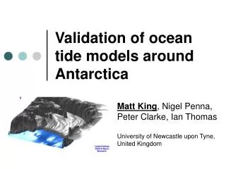
Validation of ocean tide models around Antarctica. Matt King 1 Laurie Padman 2 Helen Amanda Fricker 3 1 University of Newcastle upon Tyne 2 Earth & Space Research 3 Scripps Institution of Oceanography. Above GRACE error budget. Introduction.

E N D
Validation of ocean tide models around Antarctica Matt King1Laurie Padman2Helen Amanda Fricker3 1 University of Newcastle upon Tyne2 Earth & Space Research3 Scripps Institution of Oceanography
Above GRACE error budget Introduction • Challenges of tide modelling in circum-Antarctic oceans • Poor bathymetry/grounding line definitions • Lack of data to assimilate (south of T/P cutoff) • Model physics developments required • Results in inaccurate and/or unvalidated models • The need for accurate ocean tide models • Altimetry – especially ICESat/CryoSat • GRACE • Mismodelled tidal signals alias • S2->162 days, K2->4 y with ~100% admittance • Sub-cm tidal prediction required RMS of gravity from ocean tide model differences (AG95, FES94.2) of M2, S2, K1, and O1 combined associated with harmonic degrees 1-50.From Knudsen et al. http://research.kms.dk/~pk/pubs/grace
Tidal characteristics (CATS02.01) Topex/Poseidon cutoff
Inter-model agreement (7 models) CATS02.01, CADA00.10, FES2004, CSR4, GOT00.2, NAO.99b, TPXO6.2
Tide Models to Validate • Global • TPXO6.2 – 0.25 x 0.25°; Assimilates T/P, gravity on Ross Ice Shelf (K1, O1) • FES99, FES2004 – 0.25 x 0.25°; T/P, TG • CSR4 – 0.5 x 0.5°; T/P • GOT00.2 - 0.5 x 0.5°; T/P, ERS (not over ice shelves) • NAO.99b - 0.5 x 0.5°; T/P • Regional (south of 58°; TPXO5.2 at N boundary) • CATS02.01 – 0.25 x 0.083° (~10km at 70°S) • CADA00.10 - 0.25 x 0.083°; T/P; 37 TG, GPS and gravity sites
Validation datasets • Absolute accuracy assessment • Set of 28 long TG records (one GPS site) • Supplemented by 39 shorter records (TG; and on ice shelves GPS and gravimetric data) • “Moved” GPS/TG sites up to ~50km to get model estimate • Otherwise amplitude set to zero • Relative accuracy assessment • Onshore GPS displacement (15 sites) and gravity variations due to ocean tide loading (OTL) • Compare with OTL predictions using models
Absolute accuracy dataset • GPS data processed in a consistent manner using GIPSY/OASIS precise point positioning • Solid earth tides and ocean tide loading modelled (using TPXO6.1) • Published gravimetric data corrected for ocean tide loading • Already corrected for solid earth tides and converted to units of height by applying “free air” and direct attraction corrections • Classical harmonic tidal analysis performed on all datasets (Pawlowicz, 2002) • RMS of vector differences (M2, S2, O1, K1) computed as test statistic
Overall performance NAO.99b CSR4 Apart from southern Filchner-Ronne Ice Shelf, TPXO6.2 wins Per-constituent analysis
Per-constituent RMS TPXO6.2 best; per constituent RMS ~2-3cm NAO.99b FES99 CSR4 GOT00.2 Different Scale to previous
Regional performance FES99, CADA00.10 most accurate in Weddell Sea TPXO6.2 elsewhere
Relative accuracy assessment • Using onshore GPS and gravity data • Ocean tides periodically load Earth’s surface and it deforms (3d) • In Antarctica, this is up to ~80mm amplitude (shown) • Measurable by GPS (15 sites shown) and gravity (AMUN) • Fully independent measure of relative accuracy, over large spatial scales (hundreds of km) • Complements the use of TG data at discrete, but relatively few, points Maximum ocean tide loading displacement (mm), based on CATS02.01 + TPXO6.1
Ocean tide loading displacements • Daily GPS data analysed using GIPSY Precise Point Positioning (PPP) • Ambiguity terms not fixed to integers • Standard solid earth tide, astronomical argument and mean nodal corrections applied • Daily site coordinates and other parameters (tropospheric zenith and gradient, clocks) estimated as normal • Daily estimates (and VCV) combined to produce final estimates of OTL displacement at each site • Model estimates • Tide Model + Green’s Functions • SPOTL software (D. Agnew) used with several models • CATS02.01/CADA00.10 supplemented north of 60°S by TPXO6.1 • Misfit statistic - sum of squares of complex misfits (S2)
Fits at most sites on average <1mm2 per constituent for at least one model TPXO.6, FES99, CATS02.01, CADA00.10 fit best CSR3, TPXO.2, FES95.2, NAO.99b not appropriate near large ice shelves All constituents No K2 3d Vertical Results
CADA00.10 Gravity FES95.2 NAO.99b diamond (off scale) FES99 TPXO6.1 GOT00.2 CATS02.01 South Pole gravity • Relative gravity analysis of Knopoff et al. • Spatially integrated measure of model accuracy Units: uGal, same scale
Conclusions • TPXO6 presently the most accurate model for circum-Antarctic oceans (~5-7cm RMS for 4 constituents) • Exception is for Filchner-Ronne Ice Shelf where CATS/CADA are most accurate • CSR3, CSR4, TPXO.2 and NAO.99b are inaccurate near large ice shelves • Further improvements in model accuracy • Better grounding-line and bathymetry (esp. under ice shelves) • Accurate data to assimilate with widespread geographical coverage (ice shelves) • GPS • IceSat, CryoSat, re-tracked ERS (?) • Theoretical developments in tide model physics • If you have further TG data, please contact us
Further Information See Poster on using ICESat data for observing ocean tides – Fricker, Padman and King King, M.A., N.T. Penna, P.J. Clarke, and E.C. King (2005), Validation of ocean tide models around Antarctica using onshore GPS and gravity data, J. Geophys. Res., 110. King, M.A., and L. Padman (2005), Accuracy assessment of ocean tide models around Antarctica, Geophys. Res. Lett., under review. Padman, L., and H.A. Fricker (2005), Tides on the Ross Ice Shelf observed with ICESat, Geophys. Res. Lett., 32 (14).