
Overview
Using Remote Sensing to Track the 2010 Eruptions of Eyjafjallajökull (Icelandic Volcano) Nick Nauslar KC King. http://topics.nytimes.com/top/news/international/countriesandterritories/iceland/eyjafjallajokull/index.html. Overview. About the Eyjafjallajökull Volcano Meteorology: HYSPLIT

Overview
E N D
Presentation Transcript
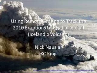
Using Remote Sensing to Track the 2010 Eruptions of Eyjafjallajökull (Icelandic Volcano)Nick NauslarKC King http://topics.nytimes.com/top/news/international/countriesandterritories/iceland/eyjafjallajokull/index.html
Overview • About the EyjafjallajökullVolcano • Meteorology: HYSPLIT • MODIS – Visible and AOD • CALIPSO LIDAR • AERONET • Conclusions
About Eyjafjallajökull • Can’t be pronounced correctly • First eruption: March 20, 2010 ranked a 1 on the Volcanic Explosivity Index (VEI) • Continuing eruptions: April 14-20 – ranked 4 on the VEI scale • ~250 million cubic meters of ejected material • Ash plume rose to a height of ~9 km (30,000 ft) • From April 15-20 the ash cloud caused airport closures all over Europe • Declared over in October 2010 http://en.wikipedia.org/wiki/Eyjafjallaj%C3%B6kull Extent of the ash cloud
Videos to Keep You Awake • Helicopter View • Time Lapse
First Eruption PhaseMODIS Visible • March 20 – First eruption • Aqua – 12:55 GMT • Too many clouds to see the eruption or get useful AOD information Greenland Iceland
Second Eruption Phase – April 14MODIS - Terra Visible AOD Sweeden Poland
Second Eruption Phase – April 15MODIS - Terra Visible AOD UK France Spain
Second Eruption Phase – April 18MODIS - Aqua Visible AOD Norway UK France
Second Eruption Phase – April 19MODIS – Terra (12:50 GMT) Visible AOD Iceland
AOD Small Fraction April 14 April 19 Sweeden Iceland Poland Larger particles in swath of high AOD
AeronetStations Helgoland Liepzig Wytham Woods
WythamWoods, UK AOD Julian Day
Liepzig, Germany AOD Julian Day
Helgoland, Denmark AOD Julian Day
Conclusions • HYSPLIT shows ash cloud over good portion of Europe • Trajectories of parcels from volcanic eruption over northern Europe • CALIPSO LIDAR shows the aerosols over parts of northern Europe. Most of it shows up as dust (volcanic ash -> larger particles) • Thought more pollution would show up due to amount of gases emitted
Conclusions Continued • MODIS shows a visible and AOD signal from Iceland and across Europe over the period April 14-20 • The fine fraction from MODIS points to relatively large particles • Individual AERONET stations across Europe also contain the signatures of the volcanic ash cloud in increased AOD
References • Air Resources Laboratory - HYSPLIT • NASA – LADSWEB • AERONET • YouTube • Wikipedia: http://en.wikipedia.org/wiki/Eyjafjallaj%C3%B6kullhttp://en.wikipedia.org/wiki/2010_eruptions_of_Eyjafjallaj%C3%B6kull • Huffington Post: http://www.huffingtonpost.com/2010/04/16/iceland-volcano-satellite_n_540449.html


