Download
1 / 41
420 likes | 723 Vues
Financial costs of settlement patterns in rural Victoria. Presentation and training session. Introductions. Agenda. 12.30 Introduction and welcome 12.35 Project background and purpose 12.40 Project approach 1.00 Settlement patterns – definition & infrastructure requirements

E N D
Financial costs of settlement patterns in rural Victoria Presentation and training session
Agenda 12.30 Introduction and welcome 12.35 Project background and purpose 12.40 Project approach 1.00 Settlement patterns – definition & infrastructure requirements 1.15 The assumptions of the model – approach and evidence 1.30 The electronic tool – inputs and outputs - example scenarios 2.00 How to vary assumptions in the model 2.30 Close
Objectives for today • How settlement patterns can influence local government finances • How to use the model to test development scenarios and reflect local characteristics
Background MAV identified a gap between revenues and the costs faced by rural councils in providing and maintaining infrastructure and services, placing significant financial pressure on local governments.
Background SGS undertook a study for MAV on the financial and triple bottom line impacts of different settlement patterns to local government. The study’s findings were: • A significant information gap exists around the cost of different settlement types • Non-contiguous development is more expensive to service • Ongoing costs were higher than the initial capital outlay over the life of the asset
Background • The study highlighted that closing the ‘information gap’ needed: • Expert input around costs of different settlements • Council input to ensure outputs were relevant and useful • Involvement from councils which had experienced growth in recent years, as they were more likely to have access to recent infrastructure provision and cost data
Project brief • Based on the findings from the previous project, RCV, together with MAV put together this project’s brief • Purpose of the project was to provide a tool to help with costing various settlement pattern options from an infrastructure and servicing point of view • SGS Economics and Planning in association with Aurecon were appointed to the project
Purpose… • To provide a strong evidence base for council via a simple modelling tool which can be used to understand and quantify costs of different settlement types in rural locations • To enable councils to use the tool to inform planning decisions, broader strategic planning initiatives and budgeting over short, medium and long term • To benefit all departments/portfolios within local government in forward planning
Approach • Identify case study councils that we would consult with to obtain cost data • Establish an Expert Reference Group that can provide feedback along the way and ensure the tool is practical and useful
Approach • Identify settlement patterns • Collect data from councils and supplement this with cost data from Aurecon • Connect settlement patterns with standard infrastructure provision ‘baskets’ • Develop a tool that was easy to use but could be tailored in various ways
Identify case study councils and introduce project Expert Reference Group Confirm settlement types Project plan September 2012- July 2013 Database development and tool framework Council consultation Data collection Expert review of data Expert Reference Group Draft Electronic Tool Pilot of tool and evaluation period Expert Reference Group Final Electronic Tool Wider briefing on the Tool
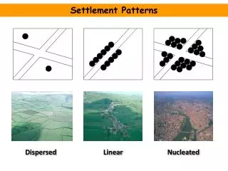
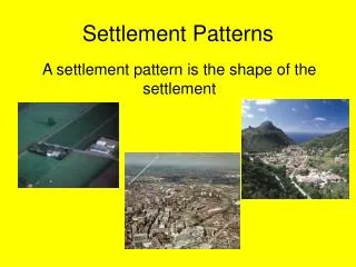
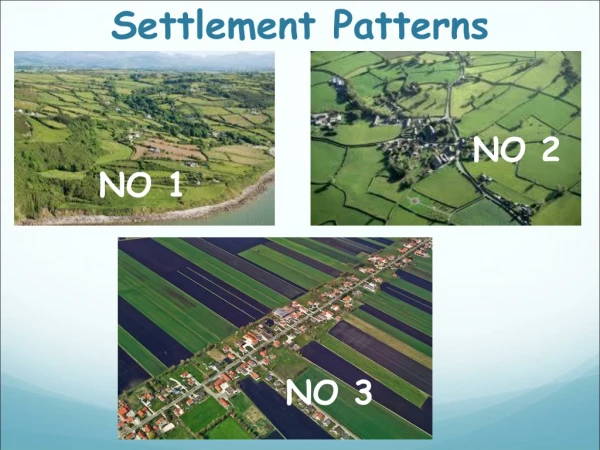
Settlement patterns • Use of settlement patterns to simplify model. Encourages planners to use the model as they often make decisions about settlement policy. • Settlement patterns are a challenge because there are so many variants • Best approach –> define three but enable the assumptions to be changed by end-users (thereby allowing countless ‘settlement types’)
Greenfield development • Brand new development in undeveloped locations which requires all infrastructure to be provided • Typically of a low density, developer driven, single dwellings • In rural Victoria, often located on the outskirts of a town/city or in high amenity locations (i.e. Coastal locations).
Greenfield development Usually zoned Residential 1 Zone/General Residential; Urban Growth Zone; Low Density Residential Zone; Rural Living Zone. Often has a Precinct Structure Plan (PSP). Examples in Warragul (see images), House & land package Drouin
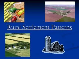
Dispersed development • Ad-hoc development which occurs over time • Often through subdivision of farms • Undeveloped land, but can hook into neighbouring infrastructure networks (existing roads, existing water pipes).
Dispersed development Usually zoned Farming Zone Examples in Ballarat, Torquay, Colac, Bairnsdale, the list goes on! Source: Domain.com.au - 121 grazing/cropping land for sale Mirboo North, marketed as one with excellent house sites
Infill development • Development which takes place in established areas • Usually occurs within towns, but more focused in regional cities • Least common development type
Infill development Usually zoned Residential 1 Zone/General Residential, Township Zone. Examples in regional cities and large towns. Leongatha, Wonthaggi, Shepparton, Ballarat, Bendigo, Broadford, Seymour 5 unit development in Leongatha, 2-3 bed each now for sale.
Linking infrastructure requirements to settlement types • Difficult because there is no standard – can vary between local governments • Also influenced by local conditions – terrain, soil, proximity to facilities • Most strongly influenced by availability and capacity of existing infrastructure • But this information is typically only known at a local level
Default assumptions Council –provided infrastructure
Default assumptions maintenance and renewal
Determining infrastructure needs by settlement type • Can be highly variable – need to create a ‘basket’ of standard infrastructure • SGS developed evidence to shape – infrastructure design manual & GIS analysis • Important that users can alter this information in the model to suit local scenarios.
Standard basket of infrastructure - drains Street based • Brick Drain 300-600mm wide • Barrier Kerb - concrete • Concrete open drain 300, 400 and 1200mm • Concrete kerb and channel 450-600mm • Kerb of timber construction • Laid back kerb 900mm • Open drain (earthen) • Plinth kerb concrete 15mm • Semi-mountable kerb and channel 300-600mm • Semi-mountable kerb and channel 600mm, and • Semi mountable kerb, no channel. Underground • Semi mountable kerb (300mm), no channel, + underground drainage, Inspection opening to house and standard house drain.
Standard basket of infrastructure – open space • Landscaped parks/gardens (including clearing of site and planting) • Retention of a natural reserve
Standard basket of infrastructure – community infrastructure • Performing Arts/Exhibition/Convention Centre • Main Library • Branch Library • Sport field (local active open space) • District Parks and Facilities • Aquatic Centre • Playground • Childcare Centre • Youth Centre • Senior Citizen Centre • Civic Centre • Multipurpose Centre • Community and Neighbourhood Centre
Determining infrastructure quantities by settlement type GIS analysis of rural dispersed and greenfield settlements was undertaken to understand the typical quantities of infrastructure provided. Case studies used from case study councils – Baw Baw, Macedon Ranges, and Surf Coast Shires Mapping lengths of roads and comparing to density
Determining infrastructure quantities by settlement type • Initial approach – make users input number of metres/km/item of each infrastructure item required • Approach not well received – only useable for engineers who often had processes for estimating costs already in place • Decided on high level ‘units per hectare’ or ‘units per dwelling’ measures
Determining potential revenues • Average rate revenue from rural councils collected – users can select their LGA’s average and apply it to the new number of households being tested • Users can also update/change the average provided • Users can also add in other funding streams • Developers (DCPs, Negotiated funds) • State or Federal funding for facilities • Aggregate rate revenue streams • Revenues from levies and fees, etc. • This allows the tool to compare potential costs to council and rates to measure the gap
What do the results say? • Results of analysis using the default assumptions showed that: • If only considering maintenance and renewal costs, rate revenue often covers these. • Rate revenue is usually insufficient to cover costs associated with new infrastructure provision • Infill performs best in terms of lowest costs, followed by dispersed and then greenfield • The model is highly sensitive to changes in assumptions, highlighting the need to enter your own for reasonable results
Implications? • Not all development costs councils the same • A range of other factors need to be considered: environmental considerations, biodiversity, traffic, infrastructure plans & capacity • Also, there are intangible benefits from increased population that may outweigh financial costs, such as renewal of places and increased business activity
The model • How to use the model – Basic Scenario • How to vary assumptions in the model to suit local conditions.
Conclusions • The default assumptions provide evidence that different settlement types have different financial implications over time. • The default assumptions and report can help to guide policy settings and encourage discussions about criteria used when deciding settlement patterns
Conclusions • Tailoring the model to suit local conditions can provide useful evidence for decision making. • However...there other costs and benefits that must be considered. It’s not all about the financial implications.
Thank you Please email any thoughts and feedback to: Daniela.jovanovic@sgsep.com.au