18-1
Pittsburg. 18-1. 18-2. 17-1-3. 18-3. Canaan. Watershed Boundary. 14-1. 14-2. 14-3. Colebrook. 10-1. 10-2. 9-1. 10-3. 9-2. 9-3. N. Stratford. 8-1. 8-3. 8-2. 7-1. 7-2. 7-3. 6-1. N. 6-2. Groveton. 6-3. 5-1. 0 km 10. 5-2. Phase 2 cross sections. 5-3.

18-1
E N D
Presentation Transcript
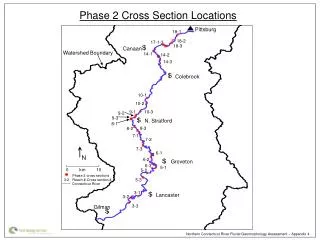
Pittsburg 18-1 18-2 17-1-3 18-3 Canaan Watershed Boundary 14-1 14-2 14-3 Colebrook 10-1 10-2 9-1 10-3 9-2 9-3 N. Stratford 8-1 8-3 8-2 7-1 7-2 7-3 6-1 N 6-2 Groveton 6-3 5-1 0 km 10 5-2 Phase 2 cross sections 5-3 3-2 Reach #-Cross section # Connecticut River 3-1 Lancaster 3-2 3-3 Gilman Phase 2 Cross Section Locations Northern Connecticut River Fluvial Geomorphology Assessment – Appendix 4
Reach 18 – Cross Section 1 Elevation (m) Bankfull Vertical Exaggeration = 4.4x Distance from left bank (m) Northern Connecticut River Fluvial Geomorphology Assessment – Appendix 4
Reach 18 – Cross Section 2 Elevation (m) Bankfull Vertical Exaggeration = 4.4x Distance from left bank (m) Northern Connecticut River Fluvial Geomorphology Assessment – Appendix 4
Reach 18 – Cross Section 3 Elevation (m) Bankfull Vertical Exaggeration = 4.4x Distance from left bank (m) Northern Connecticut River Fluvial Geomorphology Assessment – Appendix 4
Reach 17 – Cross Section 1 Elevation (m) Bankfull Vertical Exaggeration = 4.4x Distance from left bank (m) Northern Connecticut River Fluvial Geomorphology Assessment – Appendix 4
Reach 17 – Cross Section 2 Elevation (m) Bankfull Vertical Exaggeration = 4.4x Distance from left bank (m) Northern Connecticut River Fluvial Geomorphology Assessment – Appendix 4
Reach 17 – Cross Section 3 Elevation (m) Bankfull Vertical Exaggeration = 4.4x Distance from left bank (m) Northern Connecticut River Fluvial Geomorphology Assessment – Appendix 4
Reach 14 – Cross Section 1 Elevation (m) Bankfull Vertical Exaggeration = 4.4x Distance from left bank (m) Northern Connecticut River Fluvial Geomorphology Assessment – Appendix 4
Reach 14 – Cross Section 2 Elevation (m) Bankfull Vertical Exaggeration = 4.4x Distance from left bank (m) Northern Connecticut River Fluvial Geomorphology Assessment – Appendix 4
Reach 14 – Cross Section 3 Elevation (m) Bankfull Vertical Exaggeration = 4.4x Distance from left bank (m) Northern Connecticut River Fluvial Geomorphology Assessment – Appendix 4
Reach 10 – Cross Section 1 Elevation (m) Bankfull Vertical Exaggeration = 4.4x Distance from left bank (m) Northern Connecticut River Fluvial Geomorphology Assessment – Appendix 4
Reach 10 – Cross Section 2 Elevation (m) Bankfull Vertical Exaggeration = 4.4x Distance from left bank (m) Northern Connecticut River Fluvial Geomorphology Assessment – Appendix 4
Reach 10 – Cross Section 3 Elevation (m) Bankfull Vertical Exaggeration = 4.4x Distance from left bank (m) Northern Connecticut River Fluvial Geomorphology Assessment – Appendix 4
Reach 9 – Cross Section 1 Elevation (m) Bankfull Vertical Exaggeration = 4.4x Distance from left bank (m) Northern Connecticut River Fluvial Geomorphology Assessment – Appendix 4
Reach 9 – Cross Section 2 Elevation (m) Bankfull Vertical Exaggeration = 4.4x Distance from left bank (m) Northern Connecticut River Fluvial Geomorphology Assessment – Appendix 4
Reach 9 – Cross Section 3 Elevation (m) Bankfull Vertical Exaggeration = 4.4x Distance from left bank (m) Northern Connecticut River Fluvial Geomorphology Assessment – Appendix 4
Reach 8 – Cross Section 1 Elevation (m) Bankfull Vertical Exaggeration = 4.4x Distance from left bank (m) Northern Connecticut River Fluvial Geomorphology Assessment – Appendix 4
Reach 8 – Cross Section 2 Elevation (m) Bankfull Vertical Exaggeration = 4.4x Distance from left bank (m) Northern Connecticut River Fluvial Geomorphology Assessment – Appendix 4
Reach 8 – Cross Section 3 Elevation (m) Bankfull Vertical Exaggeration = 4.4x Distance from left bank (m) Northern Connecticut River Fluvial Geomorphology Assessment – Appendix 4
Reach 7 – Cross Section 1 Elevation (m) Bankfull Vertical Exaggeration = 4.4x Distance from left bank (m) Northern Connecticut River Fluvial Geomorphology Assessment – Appendix 4
Reach 7 – Cross Section 2 Elevation (m) Bankfull Vertical Exaggeration = 4.4x Distance from left bank (m) Northern Connecticut River Fluvial Geomorphology Assessment – Appendix 4
Reach 7 – Cross Section 3 Elevation (m) Bankfull Vertical Exaggeration = 4.4x Distance from left bank (m) Northern Connecticut River Fluvial Geomorphology Assessment – Appendix 4
Reach 6 – Cross Section 1 Elevation (m) Bankfull Vertical Exaggeration = 4.4x Distance from left bank (m) Northern Connecticut River Fluvial Geomorphology Assessment – Appendix 4
Reach 6 – Cross Section 2 Elevation (m) Bankfull Vertical Exaggeration = 4.4x Distance from left bank (m) Northern Connecticut River Fluvial Geomorphology Assessment – Appendix 4
Reach 6 – Cross Section 3 Elevation (m) Bankfull Vertical Exaggeration = 4.4x Distance from left bank (m) Northern Connecticut River Fluvial Geomorphology Assessment – Appendix 4
Reach 5 – Cross Section 1 Elevation (m) Bankfull Vertical Exaggeration = 4.4x Distance from left bank (m) Northern Connecticut River Fluvial Geomorphology Assessment – Appendix 4
Reach 5 – Cross Section 2 Elevation (m) Bankfull Vertical Exaggeration = 4.4x Distance from left bank (m) Northern Connecticut River Fluvial Geomorphology Assessment – Appendix 4
Reach 5 – Cross Section 3 Elevation (m) Bankfull Vertical Exaggeration = 4.4x Distance from left bank (m) Northern Connecticut River Fluvial Geomorphology Assessment – Appendix 4
Reach 3 – Cross Section 1 Elevation (m) Bankfull Vertical Exaggeration = 4.4x Distance from left bank (m) Northern Connecticut River Fluvial Geomorphology Assessment – Appendix 4
Reach 3 – Cross Section 2 Elevation (m) Bankfull Vertical Exaggeration = 4.4x Distance from left bank (m) Northern Connecticut River Fluvial Geomorphology Assessment – Appendix 4
Reach 3 – Cross Section 3 Elevation (m) Bankfull Vertical Exaggeration = 4.4x Distance from left bank (m) Northern Connecticut River Fluvial Geomorphology Assessment – Appendix 4
Comparison of Channelized and Unchannelized Segments – Reach 17 Elevation (m) Cross Section 3 - Channelized Bankfull Bankfull Cross Section 2 - Unchannelized Vertical Exaggeration = 4.4x Distance from left bank (m) Northern Connecticut River Fluvial Geomorphology Assessment – Appendix 4
Comparison of Channelized and Unchannelized Segments – Reach 14 Elevation (m) Cross Section 2 - Unchannelized Bankfull Bankfull Cross Section 3 - Channelized Vertical Exaggeration = 4.4x Distance from left bank (m) Northern Connecticut River Fluvial Geomorphology Assessment – Appendix 4
Comparison of Channelized and Unchannelized Segments – Reach 7 Elevation (m) Cross Section 3 - Channelized Bankfull Cross Section 2 - Unchannelized Bankfull Vertical Exaggeration = 4.4x Distance from left bank (m) Northern Connecticut River Fluvial Geomorphology Assessment – Appendix 4
Comparison of Channelized and Unchannelized Segments – Reach 6 Elevation (m) Cross Section 3 - Unchannelized Bankfull Cross Section 2 - Channelized Bankfull Vertical Exaggeration = 4.4x Distance from left bank (m) Northern Connecticut River Fluvial Geomorphology Assessment – Appendix 4
Comparison of Channelized and Unchannelized Segments – Reach 3 Elevation (m) Cross Section 1 - Channelized Bankfull Cross Section 2 - Unchannelized Bankfull Vertical Exaggeration = 4.5x Distance from left bank (m) Northern Connecticut River Fluvial Geomorphology Assessment – Appendix 4