Winthrop Beach Restoration Project Overview and Assessment
190 likes | 303 Vues
The Winthrop Beach Restoration Project aims to address severe erosion and beach damage through comprehensive environmental and socio-economic assessments. This initiative includes resource assessments, impact assessments, and policy analysis to evaluate the viability of potential restoration strategies. The project involves community participation, monitoring indicators for success, and exploring both upland and offshore sand sources for nourishment. Key stakeholders, including the Massachusetts Department of Conservation and Recreation, aim to finalize permitting and begin construction to secure and restore Winthrop Beach for future generations.

Winthrop Beach Restoration Project Overview and Assessment
E N D
Presentation Transcript
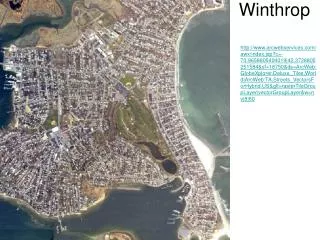
Winthrop http://www.arcwebservices.com/awx/index.jsp?c=-70.9658805404019|42.3728805251584&sf=18750&ds=ArcWeb:GlobeXplorer.Deluxe_Tiles.World|ArcWeb:TA.Streets_VectorsForHybrid.US&glt=rasterTileGroupLayer|vectorGroupLayer&w=nv|8|60
http://homeimprovement.state.ma.us/czm/chc/meetings/present/orfant_winthrop_4-10-06.pdfhttp://homeimprovement.state.ma.us/czm/chc/meetings/present/orfant_winthrop_4-10-06.pdf
Winthrop Beach Restoration project http://www.mass.gov/czm/chc/meetings/meetings.htm
Environmental Assessment Group Socio-economic Assessment Group Two Working Groups Addressing Winthrop Beach Restoration Project WHAT? WHY? WHERE? WHO? WHEN?
Applying Coastal Management General Steps for Winthrop shoreline/beach restoration: • Resource assessments (environmental) – What type of assessments were done in the Winthrop beach restoration? Why? What environmental conditions are needed for beach to exist? 2. Impact assessments – for both the shoreline/beach that needs to be restored and for sites used for creating the beach! Use conflict analysis! Describe what was in conflict and why? 3. Policy and regulatory framework – which agencies and communities participated in decision making process? 4. Economic assessment – feasibility study 5. Implementation – what was in this case critical for making a decision(s) that was made? 6. Monitoring and evaluation – identify the best indicators (natural and socio-economic)
Winthrop Beach Restoration Project:environmental assessment and suitability indicators selection
Winthrop Beach Restoration Project socio-economic assessment and selection of criteria and indicators: • Criteria and suitability indicators selection include: time frame; economic feasibility analysis; what’s the value of the beach? • Policy analysis; review and amendments of related law & regulation; • Agencies involved • Community participation
Winthrop Beach Filed trip • let's meet at 10 am on Winthrop Beach • Bus schedule from the Orient Heights stop on the Blue Line: Route 713: 9:27 (Orient Heights) - 9:41 (Winthrop Beach) Route 712: 9:40 (Orient Heights) - 9:55 (Winthrop Beach) Route 713: 10:00 (Orient Heights) - 10:14 (Winthrop Beach)
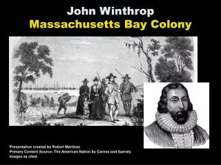
Winthrop Beach Case Study - Joe Orfant from the Massachusetts Department of Conservation and Recreation (DCR) will summarize the history of Winthrop Beach including severe storm damage, construction of a seawall, breakwaters, and groins, and development of a recent proposal to nourish the beach with 500,000 cubic yards of sediment. - Winthrop is a barrier beach between two eroding drumlins. Five upland and 14 offshore sources were considered for the beach nourishment project. Upland sources were estimated to cost at least 2-3 times that of an offshore source using a hopper dredge. The preferred offshore option is the NOMES site 1, which is eight miles southeast of Winthrop and was identified by a study funded by the National Oceanic and Atmospheric Administration (NOAA) in the 1970s as a potential aggregate source. -12-month marine biological study was conducted for NOMES 1 and a biological impact assessment report was filed in December 2002. The permit process for this project began 7 years ago. During the permitting process, $500,000 has been spent on temporary reinforcement due to undermining of the seawall and the formation of a sinkhole landward of the wall. - DCR's goal is to have all of the permits by the end of this summer and put the construction project out for bid in early fall. http://www.mass.gov/czm/chc/meetings/apr_10_2006_summary.htm
Vector layer WINTHROP
Environmental Indicators • Currents & surface waves • Bathymetry • Sediment grain size • Shoreline/beach changes • Biodiversity – indicate one-two species • Benthic and phytoplankton biomass • Pollutants – Fecal, pesticides, heavy metals
Socio-economic indicators • Resident population – owners/rentals • Population density • Land use/Land cover - watershed • Community stakeholders & Industry sectors • Property values (insurance/taxes) • Income/wealth distribution • Public access to a coastline/beach • Number of visitors/tourists & recreational activities • Maintenance and Costs of the shoreline/beach area (e.g. trash, new sand) • http://www.mass.gov/czm/coastguide/online/descriptions/winthrop_east-boston.htm