New Notes: Ocean Currents
New Notes: Ocean Currents. Warm-up: 1. Look at your buoy map – If you dropped a buoy at Latititude 10 0 and Longitude 180 0 , which direction will it drift? 2. Which direction do you think it would drift if you dropped it at Latitude -10 0 and Longitude 180 0 ?

New Notes: Ocean Currents
E N D
Presentation Transcript
New Notes: Ocean Currents • Warm-up: • 1. Look at your buoy map – If you dropped a buoy at Latititude 100 and Longitude 1800, which direction will it drift? • 2. Which direction do you think it would drift if you dropped it at Latitude -100 and Longitude 1800? • Essential Question(s): What causes the patterns of ocean currents, and how do they affect the climate of the earth?
Continue Notes: Ocean Currents • Mini-Quiz! (Answer on a separate piece of paper – I will pick it up) • 1. Generally, what direction do the ocean currents of the Northern Hemisphere move in? • 2. Generally, what direction do the ocean currents of the Southern Hemisphere move in? • 3. Tell me one other thing you learned yesterday.
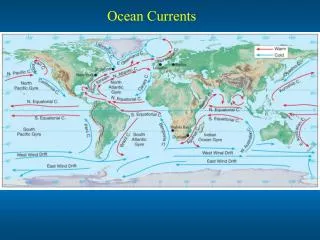
Ocean Water Movements Ocean currents are masses of water that flow from one place to another. Surface currents develop from friction between the ocean and the wind that blows across the surface. Surface circulation of the oceans are cause by many interacting “gyres”, which are large systems of rotating ocean currents, particularly those involved with large wind movements.
Ocean Water Movements Earth’s oceanic surface circulation is made up of five main gyres. North Atlantic Gyre North Pacific Gyre South Pacific Gyre South Atlantic Gyre Indian Ocean Gyre The gyres are related to atmospheric circulation.
Idealized surface circulation pattern for the Atlantic Ocean. The prevailing winds create circular-moving loops of water (gyres) at the surface in both parts of the Atlantic Ocean basin. Figure 15.2
Average ocean surface currents from February to March. The oceans circulation is organized into five major current gyres (large, circular-moving loops of water), which exist in the North Pacific, South Pacific, North Atlantic, South Atlantic, and Indian Oceans.
Large ships crossing the ocean have lost entire containers overboard. if the containers release floating items, inadvertent float meters are launched that help oceanographers track ocean surface currents. The map shows the path of drifting shoes and recovery locations from a spill in 1990.
Surface Circulation Gyres are caused by the Coriolis Effect, an apparent deflection of moving objects caused by the rotation of the earth and the inertia of the mass experiencing the effect. The Coriolis force is quite small, and its effects generally become noticeable only for motions occurring over large distances and long periods of time, such as large-scale movement of air in the atmosphere or water in the ocean. This force causes moving objects on the surface of the Earth to appear to veer to the right in the northern hemisphere, and to the left in the southern. Surface currents are extremely important to Earth’s climate, as they transfer warmer water from low latitudes into higher latitudes, and thereby move heat from warmer to cooler areas.
The Gulf Stream This false-color satellite image shows sea-surface temperatures of the Gulf Stream.Warmer waters are shown in red and orange, colder waters in green, blue, and purple.As the Gulf Stream meanders northward, some of its branches pinch off to form large, circular eddies.
Importance of Surface Currents Ocean currents have a significant influence on climate. When currents from low-latitude regions move to higher latitudes, they transfer heat from warmer to cooler areas on Earth. This is how the Gulf Stream keeps Great Britain and northwestern Europe warmer during the winter than should be expected for their latitudes. On the other hand, as cold currents originating in cold, high-latitude regions travel toward the equator, they tend to moderate the warm temperatures of adjacent land areas. For example, the cool Benguela current off the western coast of southern Africa moderates the heat along this coast.
Importance of Surface Currents Winds can also cause vertical water movements. Upwelling is the rising of cold waters from deeper layers to replace warmer surface water. Upwelling is most characteristic along the western coasts of continents where winds blow toward the equator and parallel to the coast. These winds combined with the Coriolis effect cause surface waters to move away from the shore, being replaced by cooler water “upwelling” from below. This process brings greater concentrations of dissolved nutrients to the ocean surface.
Deep Ocean Circulation Circulation in the deeper ocean is a response to density differences of water at varying depths. Recall that two factors create a dense mass of water: cold water and increased salinity. Deep-ocean circulation is referred to as thermohalinecirculation. Most water involved in deep-ocean currents begins in high latitudes at the surface A simplified model of ocean circulation is similar to a conveyor belt that travels from the Atlantic Ocean, through the Indian and Pacific Oceans, and back again