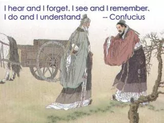
Understanding Drainage Basins: The Journey of Rivers
This resource explores the concept of drainage basins and the role of rivers in shaping landscapes. It explains the key features of drainage basins, including watersheds, sources, and confluences. The content covers the processes of erosion and transportation, detailing how rivers transport sediments and shape the environment. Additionally, it investigates the upper, middle, and lower courses of rivers, highlighting their characteristics and landforms such as V-shaped valleys and meanders. Perfect for students and nature enthusiasts alike, this guide provides foundational knowledge of river systems.

Understanding Drainage Basins: The Journey of Rivers
E N D
Presentation Transcript
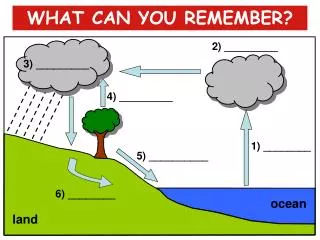
WHAT CAN YOU REMEMBER? 2) _________ 3) _________ 4) _________ 1) ________ 5) __________ 6) ________ ocean land
WHAT CAN YOU REMEMBER? condensation precipitation transpiration evaporation surface runoff ground water ocean land
PHYSICAL LANDSCAPES INTRODUCING RIVERS
WHAT ARE WE GOING TO LEARN? • What is a drainage basin? • Why is a drainage basin like a kitchen sink? • What are the four processes of erosion in rivers? • What are the four processes of transportation in rivers?
Dyfi DRAINAGE BASIN THE DRAINAGE BASIN A drainage basin is an area of land that is drained by a river and its tributaries.
THE DRAINAGE BASIN The higher land that forms the edge, or boundary, of a drainage basin is called the watershed. Nature’s ‘kitchen sink’ WATERSHED
THE DRAINAGE BASIN All the rain that falls within a drainage basin flows into a single river channel that flows to the sea (or lake). Drainage basins act like nature’s kitchen sinks.
River Basin Features • Watershed the area of high land forming the edge of a river basin. • Source where a river begins. • Mouth where a river meets the sea. • Confluence the point at which two rivers meet. • Tributary a small river or stream that joins a larger river. • Channel this is where the river flows. • Drainage Basin this is the area of land drained by a river and its tributaries.
DRAINAGE BASIN TERMS SOURCE TRIBUTARY CONFLUENCE CHANNEL MOUTH
PHYSICAL LANDSCAPES THE RIVER COURSE
THE RIVER COURSE UPPER COURSE MIDDLE COURSE LOWER COURSE
RIVER PROCESSES Rivers play a big role in shaping our landscape. They are able to do this because they have energy. This means that they can do work. The work they do is erosion and transportation. When they run out of energy they have to stop doing work, so they drop what they are carrying. This is called deposition.
EROSION PROCESSES Erosion is the wearing away of the river bed, river There are four processes of river erosion: • attrition • corrasion • corrosion • hydraulic action
TRANSPORTATION PROCESSES • There are four processes of transportation: • traction • saltation • suspension • solution
TRANSPORTATION PROCESSES Solution Suspension Traction Saltation
THE SOURCE • The source is the start or beginning of a river. • The source of a river is usually found in the hills or mountains.
SPRINGS rain Water can sink through gaps in the rocks Underground water emerges where the rock type changes Permeable rock ie Limestone Rocks are saturated Impermeable rock ie Clay Spring
THE RIVER COURSE UPPER COURSE MIDDLE COURSE LOWER COURSE
UPPER COURSE CHARACTERISTICS steep valley sides steep channel gradient narrow, shallow channel narrow valley floor
Upper Course Characteristics large, angular stones and boulders
UPPER COURSE CHARACTERISTICS turbulent river flow at a section of rapids
Upper Course Landforms a typical V-shaped valley
Key Features: • V-shaped valley A steep sided and narrow valley that is formed due to vertical erosion. The load of the river cuts downwards and deepens the bed of the river.
Upper Course Landforms a typical V-shaped valley
Upper Course Landforms interlocking spurs interlocking spurs
Upper Course Landforms interlocking spurs interlocking spurs
WATERFALL RETREATS . . OVERHANG PLUNGE POOL UNDERCUTTING OF SOFT ROCK UPSTREAM . .
Upper Course Landforms interlocking spurs interlocking spurs
Rapids A series of gentle breaks in the slope of a river bed due to different types of rock.
Upper Middle Lower Course Course Course River Model
S3 Rivers: The Middle Course
At the middle stage of the river the valley sides become less steep • The river is now wider and deeper • It does not flow at the same speed throughout its middle course, some parts are slower, some are faster
What do you notice about thebank of the river channel on the outside of the bend?
Why do rivers meander (bend)? • Copy the diagram above and put the following labels in the correct place: • Deposition Fast flow of river Shallow water • River Cliff Lateral Erosion Slow flow of river Deeper water River beach (Slip-off slope) • 2. Describe why one side of the river bend is different from the other.