1 / 1

Quality Assessment of Roads in Colorado Based on Satellite Imagery

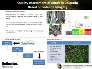
Quality Assessment of Roads in Colorado Based on Satellite Imagery. Road condition surveillance is a tedious task which requires manual inspection of thousands of miles of road length

delta
Télécharger la présentation

Quality Assessment of Roads in Colorado Based on Satellite Imagery

An Image/Link below is provided (as is) to download presentation Download Policy: Content on the Website is provided to you AS IS for your information and personal use and may not be sold / licensed / shared on other websites without getting consent from its author. Content is provided to you AS IS for your information and personal use only. Download presentation by click this link. While downloading, if for some reason you are not able to download a presentation, the publisher may have deleted the file from their server. During download, if you can't get a presentation, the file might be deleted by the publisher.

E N D

Presentation Transcript


  1. Quality Assessment of Roads in Colorado Based on Satellite Imagery Road condition surveillance is a tedious task which requires manual inspection of thousands of miles of road length Our study has determined that an automated satellite remote sensing based method can be established for this task We are now working towards designing and developing such a solution Satellite Imagery Road Identification We’re here Image Analysis Road Condition Assessment 21B 115A 24A

More Related