Download
1 / 1
10 likes | 184 Vues
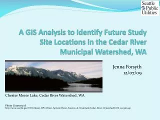
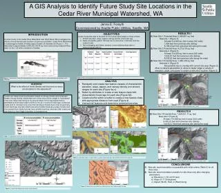
A GIS Analysis to Identify Future Study Site Locations in the Cedar River Municipal Watershed, WA. Jenna E. Forsyth Commissioned by Seattle Public Utilities, Seattle, WA. RESULTS I (1) New Site 1 Potential Area: 5,368,861 sq. feet New site 1 (Figure 5)

E N D
A GIS Analysis to Identify Future Study Site Locations in the Cedar River Municipal Watershed, WA Jenna E. Forsyth Commissioned by Seattle Public Utilities, Seattle, WA • RESULTS I • (1) New Site 1 Potential Area: 5,368,861 sq. feet • New site 1 (Figure 5) • At least 114,528 sq. feet in area (5x5 cells) • 1,854 feet from previous site (skiing) • 8,158.4 feet from previous site (along the road). • (2) New Site 2 Potential Area: 4,273,018 sq. feet • New site 2 (Figure 5) • At least 114,528 sq. feet in area (5x5 cells) • 7,532.67 feet from previous site (skiing) • 8,035.22 feet from previous site (along the road) • (3) New Site 3 Potential Area: 1,458,128 sq. feet • New site 3 (Figure 5) • Not possible due to overlap with current site area (Figure 5). • Must re-classify parameters to allow for larger range of values of elevation, slope, and aspect to obtain a new site 3 location (Figure 6). • OBJECTIVES • Locate 3 potential sites to be pairs for the current sites based on these criteria: • Similar elevation, slope, aspect, canopy density, and forest age • Easily accessible (within 100 feet, but no more than 1,000 feet from the nearest road) • Not overlapping with lakes, streams, or pre-existing study sites or meteorological stations INTRODUCTION A current study in the Cedar River Watershed near North Bend, WA investigates the effects of forest density and structure on snow accumulation. Cedar River Watershed is located approximately 34 miles east of Seattle off Interstate-90 (Figure 1). The watershed is approximately 3,946,330,736.44 sq. feet in area and provides drinking water for the 1.45 million residents of Seattle. Table 2. Forest and topographic characteristics of current study sites. Figure 1. Location of the Cedar River Municipal Watershed with current study sites, and meteorologic and hydrologic station information. • ANALYSIS • Reclassify and create new feature classes of characteristic • elevation, slope, aspect, and canopy density (not shown) ranges for each site (Figure 3a-c). • Select by attributes to create a new feature class with characteristic forest age for each site (Figure 3d). • Create a buffer within a buffer to create a new feature class with appropriate distance from road (Figure 4) • Intersect all features and determine potential new sites. QUESTION What is the effect of forest density and structure on snow accumulation in the watershed? Forests can impact snow accumulation based on canopy density and forest type. Greater canopy density means that more of the snow will be caught or “intercepted” in the trees rather than falling to the ground. Much of this intercepted snow is sublimated and the water vapor returns to the air. In terms of forest type, coniferous forests tend to intercept more snow than deciduous forests due to branch geometry. Forest stand age may also affect snow accumulation because younger forests tend to be packed more tightly but may have smaller branches, whereas older forests are less dense but have bigger branches to intercept snow. Figure 5. Potential areas and new site locations fitting all criteria for sites 1 and 2. • RESULTS II • (3) New Site 3 Potential Area: 7,528,051.11 sq. feet • New site 3 (Figure 6) • At least 114,528 sq. feet in area (5x5 cells) • 6,433.21 feet from previous site (skiing) • 14,415.37 feet from previous site (along the road) a) b) Table 1. Canopy density, forest age, and forest type positively or negatively affect snow accumulation. d) c) Figure 3. a) Elevation ranges, b) slope ranges, c) aspect, and d) forest ages representative of the current study sites. Figure 6. Potential areas and new site locations fitting all criteria for sites 1,2 (no change), and 3. • CONCLUSIONS • 1) New site recommendation not possible with initial criteria (Table 2) for all three sites. • 2) New site recommendation possible for site three only after changing parameters: • Elevation (1,731-2,676 feet) • Slope (0-17.09 degrees) • Aspect (North, East, or West facing) Figure 4. Potential site area greater than 100 feet but less than 1,000 feet from the road. Figure 2. Cedar River Watershed current study locations.