Download
1 / 44
440 likes | 463 Vues
Join Dr. Theresa Diehl in this informative webinar exploring the GRAV-D program and the pivotal role of NGS in redefining the American Vertical Datum. Gain insights into the history, challenges, and future plans of this crucial geodetic initiative.

E N D
The Gravity for the Redefinition of the American Vertical Datum (GRAV-D) Project Dr. Theresa Diehl Research Geodesist Webinar Given on May 9, 2011
PART I Overview of the need for and inception of the GRAV-D program Program goals and plans to achieve them Current status of program Near-term plans over the next few fiscal years Now In Part II
NGS’s Role and Authority on Vertical Datums OMB Circular A-16 (revised)*: • Names DOC and NOAA as “lead agency” for Geodetic Control, and says: • “All NSDI [National Spatial Data Infrastructure] framework data and users' applications data require geodetic control to accurately register spatial data.” • “The National Spatial Reference System is the fundamental geodetic control for the United States.” *[originally issued in 1953, revised in 1967 and again in 1990]
NGS’s Role and Authority on Vertical Datums OMB Circular A-16 (revised): • Hence, the NSRS responsibility falls to NGS • NGS Mission: “To define, maintain, and provide access to the National Spatial Reference System (NSRS) to meet our nation’s economic, social, and environmental needs” • NSRS includes the horizontal and vertical datums, the national shoreline, and a variety of other components. • www.whitehouse.gov/omb/Circulars/a016/a016_rev.html
NGS’s Role and Authority on Vertical Datums Federal Geodetic Control Subcommittee (FGCS) Federal Register Notice (Vol. 58, No. 120) • Affirms “NAVD 88 as the official civilian vertical datum for surveying and mapping activities in the United States performed or financed by the Federal Government. • “To the extent practicable, legally allowable, and feasible, require that all Federal agencies using or producing vertical height information undertake an orderly transition to NAVD 88.” • http://www.ngs.noaa.gov/PUBS_LIB/FedRegister/FRdoc93-14922.pdf
NGS’s Role and Authority on Vertical Datums • Summary: • OMB A-16 establishes DOC/NOAA (implying NGS) as lead agency for NSDI geodetic control (the NSRS) • NAVD 88 is the vertical datum of the NSRS • FGCS requires that NAVD 88 heights be used in all civilian federal surveying and mapping • These regulations do not apply to DoD nor to state and local surveying, but these groups often do adopt NAVD 88
"topographic map." Online Art. Britannica Student Encyclopædia. 17 Dec. 2008 <http://student.britannica.com/ebi/art-53199> What is a Vertical Datum? • Strictly speaking, a vertical datum is a surface representing zero elevation • Traditionally, a vertical datum is a system for the determination of heights above a zero elevation surface • Vertical datum comprised of: • Its definition: Parameters and other descriptors • Its realization: Its physical method of accessibility
History of Vertical Datums in the USA • NAVD 88: North American Vertical Datum of 1988 • Definition: The surface of equal gravity potential to which orthometric heights shall refer in North America*, and which is 6.271 meters (along the plumb line) below the geodetic mark at “Father Point/Rimouski” (NGSIDB PID TY5255). • Realization: Over 500,000 geodetic marks across North America with published Helmertorthometric heights, most of which were originally computed from a minimally constrained adjustment of leveling and gravity data, holding the geopotential value at “Father Point/Rimouski” fixed. Father Point Lighthouse, Quebec *Not adopted in Canada
History of Vertical Datums in the USA • NAVD 88 (continued) • Defined only on the conterminous North American continent • Does not (and cannot) exist for any place you can’t level to from Father Point, such as: • Guam, American Samoa, Hawaii, Puerto Rico, American Virgin Islands, Commonwealth of the Northern Marianas, Aleutian Islands • Height chosen was to minimize 1929/1988 differences in USGS maps • “Zero height surface” of NAVD 88 wasn’t chosen for its closeness to the geoid (but it was close…few decimeters)
History of Vertical Datums in the USA • NAVD 88 (continued) • Use of one fixed height removed local sea level variation problem of NGVD 29 • Use of one fixed height did open the possibility of unconstrained cross-continent error build up • The H=0 surface of NAVD 88 was supposed to be parallel to the geoid…(close again)
Problems with NAVD 88 • NAVD 88 relies upon bench marks that: • Disappear by the thousands every year • Are not funded for replacement • Are almost never re-checked for movement • Are not necessarily in convenient places • Don’t exist in most of Alaska • Weren’t adopted in Canada • Cross-country error build up
Problems with NAVD 88 NAVD 88 suffers from azero height surface that: • Has been proven to be ~50 cm biased from the latest, best geoid models (GRACE satellite) • Has been proven to be ~ 1 meter tilted across CONUS (again, based on the independently computed geoid from the GRACE satellite)
Problems with NAVD 88 Earth’s Surface H (NAVD 88) H NAVD 88 reference level The Geoid Errors in NAVD 88 : ~50 cm average, 100 cm CONUS tilt, 1-2 meters average in Alaska NO tracking of temporal changes
Problems with NAVD 88 Approximate level of geoid mismatch known to exist in the NAVD 88 zero surface
Can NAVD 88 be fixed? Short term fix: Height Modernization GPS surveys • Quick way to propagate NAVD 88 bench mark heights to new marks through the use of GPS and a constrained least squares adjustment • NOAA TM NOS NGS 58 and 59 guidelines • Keeps NAVD 88 useful and accessible, but does not address the majority of problems of NAVD 88 itself Lack of roads prevents Height Modernization surveys from propagating heights to western AK
Can NAVD 88 be fixed? • Long term fix: Re-level some/all of NAVD 88 • 81,500 km of 1st order leveling at least • 625,000 km of mixed 1st and 2nd order leveling • Re-leveling NAVD 88 estimated to cost between $200 Million and $2 Billion • Still have problems related to passive control
Can NAVD 88 be fixed? Long term fix: Replace NAVD 88 • GRAV-D: Gravity for the Redefinition of the American Vertical Datum • GRAV-D will: • define the datum as a given geoid model • realize it through GNSS technology • spanat least the United States and its territories
What is GRAV-D? • Official NGS policy as of Nov 14, 2007 as part of 10 yr plan 2008-18 • Estimated $38.5M over 10 years • Three thrusts of project: • Airborne survey “snapshot” • Long-term monitoring of geoid change • Partnership surveys • Re-define the Vertical Datum of the USA by 2022 (given funding levels)
GRAV-D • Target: orthometricheights from GNSS and a geoidmodel; accurate to 2 cm • GRAV-D would mean fast, accurate, consistent orthometric heights everywhere in the USA
GRAV-D • One consistent vertical datum for the entire US: Continental US, Alaska, Hawaii and Pacific Islands, and Puerto Rico and the US Virgin Islands • Long-term objective: North American datum from equator to Arctic • Already in talks to coordinate our datum with Canada, Mexico, Caribbean, Central America
A good-enough geoid? • Target 2 cm accuracy in orthometric heights assumes: • 1 cm accuracy in GNSS positioning • 1 cm accuracy in Geoid • An accurate geoid requires: • A sufficiently good gravity field • Good geoid theory • Under revision by Y. Wang (IAG study group)
Gravity Field Before GRAV-D • Blend of various gravity data: • GRACE satellite gravity (wavelengths ≥ 350 km) And • NGS gravity holdings: land surface and marine measurements
Problems with Gravity Holdings 20-100 km gravity gaps along coast Terrestrial gravity • Field is not sampled uniformly • Data range in age and quality, some w/o metadata • Some surveys have systematic errors • Data gaps in littoral areas Ship gravity New Orleans
Gravity Field Recovery for Geoid Airborne gravity “snapshot”: survey entire region • Cover the country quickly and consistently with 20 km resolution • Fill in littoral data gaps • Connect terrestrial to: • Near-shore marine gravity data • Deep-water satellite altimetric gravity fields
Building a Gravity Field Long Wavelengths (≥ 250 km) GRACE/GOCE/Satellite Altimetry + Intermediate Wavelengths (500 km to 20 km) Airborne Measurement + Short Wavelengths (< 100 km) Surface Measurement and Predicted Gravity from Topography
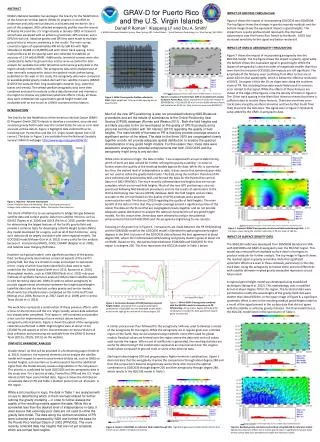
GRAV-D Coverage Puerto Rico US Virgin Is.
GRAV-D Coverage Hawaii Guam Am. Samoa
Airborne Gravity Objectives • Survey the entire US and its holdings by 2022 • Line spacing of 10 km • Extend flight lines out beyond shelf break • Complete the survey according to the following metric: • 8% per year to be completed, FY12 – FY22
Survey Priority Order • Alabama test region • Puerto Rico/US Virgin Islands • Gulf of Mexico (except Florida) • Alaska • Eastern US Seaboard (& FL)/Great Lakes • Western US Seaboard • Hawaii, Guam/CNMI, American Samoa • Interior CONUS • Aleutian Islands
GRAV-D Airborne Surveys • Gulf of Mexico 2008-09 (AL08, LA08, LA09, TX09) • Puerto Rico/US Virgin Islands 2009 (PV09) • Alaska 2008-10 (AK08, AK09, AK10-01, AK10-02, AK10-03) • California 2011 (CA11-01) • Alaska 2011 (AK11-01 underway, AK11-02 planned) 12 surveys, Over 12% of total area flown
Status of Completion Metric • Tracked monthly • Much more completed in early FY11 compared to FY08/09/10 due to long-range aircraft available (PC-12 from BLM and P-3 from NOAA) and an experienced field team
Basic Airborne Operations • Aircraft • Instrumentation • Relative gravity meter aboard aircraft • Inertial measurement unit • GNSS receivers included in both instruments • GPS base stations (three for redundancy) • Gravity tie • New absolute measurement • Relative tie to meter height in plane Impact of Airborne Gravity Surveys on Geoid Modeling in Alaska Thursday, 0800-1200
Airborne Instruments IMU TAGS
Terrestrial Gravity Tie • Absolute gravity sites not usually near airport and occupations often not recent. • Set new gravity marks where necessary and at each airport of operations, for future use. • Do all new absolute gravity readings and ties/gradients. • 2008-2010, FG-5 + G-meter relative instruments • 2011, A-10 + upgraded relative
GRAV-D Team • Vicki Childers • Theresa Diehl • Sandy Preaux • Justin Dahlberg • Greg Watson • Tim Wilkins • Carly Weil (not pictured) • Also pictured NOAA pilots Scott Price and Mark Sweeney • Plus, data processors 2010 NGS Convocation
Field Capability • Developing the project from scratch • Instrumentation • Acquisition, engineering, installation, troubleshoot • Operating procedures • Data Handling • QC: equipment working, data quality sufficient • Metadata creation, data archival, shipment to HQ • More info: “GRAV-D on the Airfield” presentation http://www.ngs.noaa.gov/GRAV-D/materials.shtml
Field Capacity: Challenges • Field team depth • Need a dedicated aircraft • Present NOAA capacity is limited • Need both a long- and a shorter-range aircraft • Modifications for USGS magnetometer • Needed instrumentation • Inertial measurement unit • Electronics racks
Break Back in 10 minutes