NCAR Command Language
ESMF Regridding Software in NCL ESMF Executive Board Interagency Working Group Meeting June 12, 2014 Mary Haley NCAR/CISL/VETS Special thanks to NOAA/CIRES team Robert Oehmke, Cecelia DeLuca, Peggy Li. NCAR Command Language.

NCAR Command Language
E N D
Presentation Transcript
ESMF Regridding Software in NCLESMF Executive BoardInteragency Working Group MeetingJune 12, 2014Mary Haley NCAR/CISL/VETSSpecial thanks to NOAA/CIRES teamRobert Oehmke, Cecelia DeLuca, Peggy Li
NCAR Command Language An open source scripting language developed and supported at NCAR, tailored for the analysis and visualization of geoscientific data http://www.ncl.ucar.edu
NCL’s main features • Simple, robust file input and output • Hundreds of analysis (computational) functions • Visualizations are publication quality and highly customizable • Free and well-supported • Training available
Types of research reported by NCL userss ecosystem model electric power extreme weather events fire weather forecasting fish climate flight experiments fluid dynamics fog forecast forest productivity fusion plasma geophysics support glacial climate studies greenhouse modeling heat balance heavy rainfall historical weather maps humidity projections hurricanes hydrology modeling improvement of dairy cattle insect research ionospheric studies lake effect snow storms larval transport lightning research magnetic resonance imaging magnetohydrodynamics mapping epidemiological datamarine studiesmartian climatematerial stress and strainmercury depositsmeso-gamma simulationsmicrobiologymicroburst outflows modeling of stem cells molecular physics monsoon studies morphodynamics, long term neuron model noble gas sampling ocean biology ocean eddy research oceanography optical data, display of ozone paleoclimate studies particle orbit physics planetary exploration data plasma simulation polar research radiation risk research radiowave propagation real-time ocean forecasting remote sensing renewable energy rice production road weather research satellite image processing scattometer studies sea breeze simulation sea ice studies sediment transport research ships in waves simulations snake bites in Brazil snow data assimilation soaring conditions for gliders social sciences soil moisture solar irrigation changespace geodesyspace weather spread of farming & milk drinking star modeling station data plots storm surge analysis storms, forecasting of surf charts teaching tokamak modeling tornado climatology transport of aerosols from oil facilities tropopsheric air pollution turbulent particle-laden flow typhoon research urban flood demonstration urban meteorology volcanic signals in ice cores water resources and irrigation water vapor feedback weather display weather forecasting for sailboats weather modification wildfire simulation wildlife conservation and restoration program wind energy wind erosion wind forecasting for wind surfers wind resources DTV propagation analysis IPCC research MARS cam NASA precipitation missions air quality research air science air ventilation assessment air-sea interaction aircraft icing research animal disease modeling applied insurance astronomy atmospheric research atmospheric teleconnections atomic energy aviation forecasting battlespace environment modeling bauxite refinery beam physics biofuels modeling biogeochemistry bird migration black hole bluetongue transmission risk borehole temperatures bushfire mitigation carbon cycle modelling cell motility climates of extrasolar planets cloud parameterization dimethylsulphoniopropionate disaster prevention drought predicting dust earth magnetic field
NCL users are worldwide • Graduate students in climate sciences • Scientists at research centers and labs • Some commercial usage
NCL metrics • 19,500 registered users in over 100 countries since 2010 • 1,500 monthly downloads • 2,019 email list subscribers • 270 monthly emails (includes responses) • 70 workshops since 2000 (1,030 students)
Joint student project at NCAR/CISL with NOAA/CIRES Develop a suite of functions to incorporate the ESMF regridding capabilities in NCL. Mohammad AboualiSIParCS Intern at CISL/NCAR, 2011Computational Science Ph.D. Studentat Joint Program between SDSU & CGU Very successful project!Released in NCL beta version in May 2012, and officially in October 2012
Why ESMF regridding? • One interface to handle different grid types (rectilinear, curvilinear, unstructured) • Easy to switch interpolation methods • Works on global or regional grids • Can use weights for faster regridding • Can run in parallel • Know the team members
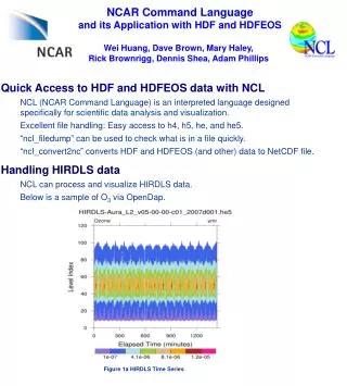
Uses for ESMF regridding • CMIP5 regridding suite • WRF (weather and research forecast) model data to other grids • Spatially merging Daymet NetCDF files • ECMWF Operational Model Analysis grid • Ocean models (ROMS, POP, ORCA) • Unstructured grids (MPAS, HOMME, ICON) (hexagonal, cubed) • CLM (land surface model) • HDF satellite (swath) data • CCSM grid to EASE grid • GPCP (Global Precipitation Climatology Project) • CCSM ice to CCSM atmospheric • HIRLAM (hydrostatic grid-point model, can be rotated) • MOZART emissions
NCL/ESMF Regridding http://www.ncl.ucar.edu/Applications/ESMF.shtml
Questions? Mary Haley haley@ucar.edu