Download
1 / 1
20 likes | 150 Vues
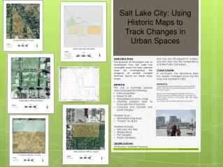
Salt Lake City: Using Historic Maps to Track Changes in Urban Spaces. INTRODUCTION: The purpose of this project was to investigate how Salt Lake has changed since the early pioneer days by investigating the longevity of several notable features found on these early maps. METHOD:

E N D
Salt Lake City: Using Historic Maps to Track Changes in Urban Spaces • INTRODUCTION: • The purpose of this project was to investigate how Salt Lake has changed since the early pioneer days by investigating the longevity of several notable features found on these early maps. • METHOD: • This was a multi-step process which included the following: • Data acquisition • Import to GIS • Georeference historic maps • Creating polygon layer to trace prominent features • Compare and contrast with aerial imagery • Notable issues: • Georeferencing issues • “Collars” on GLOs • Notable features: • Salt Lake City Wall • Temple Block • Fort Douglas • Public Cemetery • OBSERVATIONS: • Of the four “notable” features only two are still present in modern day Salt Lake City (The Temple Block and the Public Cemetery). CONCLUSION: In conclusion, the downtown area has greatly changed since the first map was created in 1855. REFERENCES: Automated Geographic Reference Center (AGRC). (2013). Salt Lake County Aerial Imagery. Retrieved from gis.utah.gov Bureau of Land Management (BLM) Public Room. (2013). General Land Office Maps for Townships T1N R1W, T1N R1E, T1S R1W, T1S R1E (1855, 1856, 1869, 1885). Retrieved from www.ut.blm.gov/LandRecords/search_plats.cfm Please note the “City Wall” Example of 1855 GLO (T1N R1W) Syanna T. Madsen April 28, 2013