Download
1 / 20
200 likes | 313 Vues
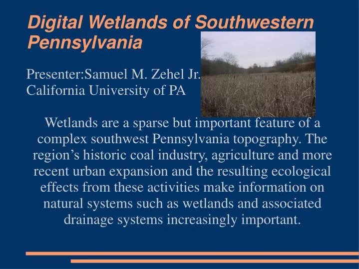
Digital Wetlands of Southwestern Pennsylvania. Presenter:Samuel M. Zehel Jr. California University of PA

E N D
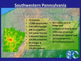
Digital Wetlands of Southwestern Pennsylvania Presenter:Samuel M. Zehel Jr. California University of PA Wetlands are a sparse but important feature of a complex southwest Pennsylvania topography. The region’s historic coal industry, agriculture and more recent urban expansion and the resulting ecological effects from these activities make information on natural systems such as wetlands and associated drainage systems increasingly important.
Long-term Goal • Provide a unique, interactive digital database and web-mapping service within a geographic information system for public utilization of mapping data for wetland status, function, and associated resource vulnerability assessment.
User Wishes • Searchable • Readable • Accessible • Reliable • Expandable • Informative
Equipment Design & Implementation • Dell Poweredge 2950 • Intel Xeon E5320 @ 1.8 GHz • 4 Gigabytes RAM • 600 GB Drive space • Microsoft • Windows Server 2003, Standard Edition • SQL Server 2005 • IIS 6.0(Internet Information Server) • Microsoft Office 2003 format • Text Editor – HTML design • ESRI(Environmental Systems • Research Institute) • ArcGIS Server 9.2 • ArcGIS Desktop 9.2
Geographical Information System Design • Datum:North American 1983 • Projection:US State Plane 83 (Pennsylvania South) • External Maps • USGS - Digital Raster Graphics quadrangles(DRG) & National Hydrography Dataset(NHD) : http://www.usgs.gov • Fish and Wildlife Service(FWS) - National Wetlands Inventory(NWI) : http://www.fws.gov/nwi • PennsylvaniA Spatial Data Access(PASDA) - Aerial Photography of Westmoreland County : http://www.pasda.psu.edu
GIS Design (cont.) • External Maps (cont.) • United States Department of Agriculture(USDA) National Resources Conservation Service(NRCS)- Soil Survey Map : http://soils.usda.gov • Unidata & the University Corporation for Atmospheric Research (UCAR) – Real-time Satellite cloud cover of Eastern Continental U.S.: http://www.unidata.ucar.edu • Internal Map (gathered field data) • 160 + points surveyed using GPS, photography, and Wetlands Assessment tools. • Name, location, assessment data and images linked together in a searchable web interface.
Field Survey Data Collection Design Wetland Assessment Level 1 REMOTE SENSING DATA NO SITE VISIT Level 2 RAPID ASSESSMENT SITE VISIT WITH HABITAT, FUNCTION, & STRESSOR CHECKLISTS Level 3 FUNCTIONAL OR BIOLOGICAL ASSESSMENTS DETAILED QUANTITATIVE CHEMICAL, AND/OR PHYSICAL, AND/OR BIOLOGICAL DATA COLLECTION
Purpose & Function • Assessment tool primarily developed as a tool for performing regulatory categorization of wetlands by Ohio EPA • For our study: modified from Ohio Rapid Assessment Method (ORAM) • Focus is on overall wetland condition and ecological integrity; indirectly function
Parts of RAM • 5 main parts of RAM: • BACKGROUND INFORMATION SECTION • SCORING BOUNDARY SECTION • NARRATIVE RATING QUESTIONS • QUANTITATIVE RATING QUESTIONS • CATEGORIZATION WORKSHEET
Wetland Assessment Metrics • Disturbancemetrics • buffer width, intensity of surrounding land use, hydrologic, substrate, and habitat intactness • Othermetrics • Size, water source, hydroperiod, connectivity, habitat development, special wetland communities (e.g., bog, old growth), plant community quality, microtopography, habitat heterogeneity, amphibian habitat
Field Data to Database Translation • Sample hand-written page • (background information)
Field Data to Database Translation(cont) • Sample Word doc. • (background information)
Fulfilling User Needs • By combining public data with field survey data, we hope to provide the user community with a tool that can be used to compare/contrast wetlands conditions from the past, and into the future.
Time/Cost Analysis Public data VS. Private data Advantages Price/Availability Timely Established Specific Disadvantages Mundane Costly General Niche data
Strengths and Advantages • Recent & accurate field data using rapid assessment site visit with habitat, function, & stressor checklists • More detailed information on habitats than other surveys of the area • Several layers available to compare • Ease & availability of use.
Next Steps of Action • Provide wetland metrics in descriptive as well as numeric representation • Improve/update field survey metadata • Include map search by city & street address as well as name (currently only wetland available) • Improve speed & reliability of mapping app. • Increase & improve data content (more surveys) • Represent wetland by polygon instead of point.
Next Steps(cont.) Show where plant communities are located in polygon form (not points)
Thanks to: • California University of Pennsylvania Faculty, Staff and Students (www.cup.edu) • Government Agencies: • Environmental Protection Agency for Primary Funding(www.epa.gov) • USGS, FWS, and USDA for map data (www.usgs.gov, www.fws.gov&www.usda.gov) • ESRI Technical Support (support.esri.com) • Unidata real-time satellite cloud cover imagery(www.unidata.ucar.edu)