Tsunami Forecasting
West Coast/Alaska Tsunami Warning Center Operations National Weather Services, National Oceanic and Atmospheric Administration Tsunami detection, forecast and warning to protect lives and properties. Tsunami Forecasting. Products. Seismic Data Acquisition and Processing. Tsunami Travel Times

Tsunami Forecasting
E N D
Presentation Transcript
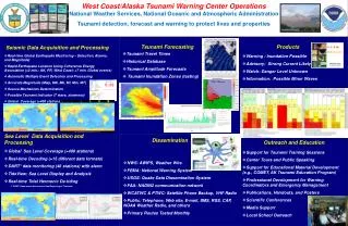
West Coast/Alaska Tsunami Warning Center OperationsNational Weather Services,National Oceanic and Atmospheric Administration Tsunami detection, forecast and warning to protect lives and properties Tsunami Forecasting Products Seismic Data Acquisition and Processing • Tsunami Travel Times • Historical Database • Tsunami Amplitude Forecasts • Tsunami Inundation Zones (testing) • Real-time Global Earthquake Monitoring – Detection, Alarms, and Magnitude) • Rapid Earthquake Location Using Coherence Energy Association (<2 min.: AK, PR, West Coast; <7 min. Global events) • Automatic Multiple Event Detection and Processing • Accurate Magnitude (Mwp, MS, Mb, Ml, Mm, MT) • Source Mechanism Determination • Possible Tsunami Indicator (T wave, slowness) • Global Coverage (>400 stations) • Warning : Inundation Possible • Advisory: Strong Current Likely • Watch: Danger Level Unknown • Information: Possible Minor Waves Sea Level Data Acquisition and Processing Dissemination Outreach and Education • Global Sea Level Coverage (>400 stations) • Real-time Decoding (>15 different data formats) • DART* data monitoring (46 stations) with alarm • TideView: Sea Level Display and Analysis • Real-time Tidal Harmonic De-tiding • *DART: Deep-ocean Assessment and Reporting of Tsunamis • Support for Tsunami Training Sessions • Center Tours and Public Speaking • Support for Educational Material Development (e.g., COMET, AK Tsunami Education Program) • Professional Development for Warning Coordinators and Emergency Management • Publications, Handouts, and Posters • Scientific Conferences • Media Support • Local School Outreach • NWS: AWIPS, Weather Wire • FEMA: National Warning System • USGS: Quake Data Dissemination System • FAA: NADIN2 communication network • WCATWC & PTWC: Satellite Phone Backup, VHF Radio • Public: Telephone, Web site, E-mail, SMS, RSS, CAP, NOAA Weather Radio, and others • Primary Routes Tested Monthly